Bardwell, Kentucky

Last updated

Bardwell, Kentucky
Bardwell-City-Park-church-ky.jpg
Tiny church at Bardwell City Park
Carlisle County Kentucky Incorporated and Unincorporated areas Bardwell Highlighted 2103664.svg
Location of Bardwell in Carlisle County, Kentucky.
Coordinates: 36°52′22″N89°0′36″W / 36.87278°N 89.01000°W / 36.87278; -89.01000
Country United States
State Kentucky
County Carlisle
Area
[1]
  Total0.87 sq mi (2.24 km2)
  Land0.86 sq mi (2.24 km2)
  Water0.00 sq mi (0.01 km2)
Elevation
361 ft (110 m)
Population
 (2020)
  Total714
  Density826.39/sq mi (318.91/km2)
Time zone UTC-6 (Central (CST))
  Summer (DST) UTC-5 (CDT)
ZIP code
42023
Area codes 270 & 364
FIPS code 21-03664
GNIS feature ID0486336

Bardwell is a home rule-class city in and the county seat of Carlisle County, Kentucky, United States. [2] The city was formally incorporated by the state assembly in 1878. [3] The population was 714 at the 2020 census, down from 723 in 2010. Bardwell is included in the Paducah, KY-IL Metropolitan Statistical Area.

Contents

History

A train arrives at Bardwell's Illinois Central station, circa 1910 Bardwell Illinois Central station postcard.png
A train arrives at Bardwell's Illinois Central station, circa 1910

Bardwell was founded in 1874 when a predecessor rail line of the Illinois Central Railroad was extended to that point. It may have initially been known as "Crittenden" after Governor John J. Crittenden, but that name was already in use elsewhere in the state, so the name was changed to "Bardwell." According to some sources, "Bardwell" was the name of a railroad superintendent whose name had been applied to a railroad construction camp near the town site. Other sources suggest the name was inspired by a "boarded well" at the camp. [4]

During their session of 1877–1878, the Kentucky General Assembly passed an act incorporating Bardwell. The original municipal boundaries consisted of a circle with a radius of 0.5 miles (0.80 km), centered on the local train station for the Illinois Central Railroad. [5]

Upon the creation of Carlisle County in 1886, the nearby city of Arlington was initially named the seat of the new county. Bardwell challenged this decision, however, and due to Bardwell's more central location, county officials agreed, and moved the seat to Bardwell. [6]

Geography

Bardwell is located northwest of the center of Carlisle County at 36°52′22″N89°0′36″W / 36.87278°N 89.01000°W / 36.87278; -89.01000 (36.872690, -89.010026). [7] U.S. Routes 51 and 62 intersect in the northern part of the city. US 51 leads south 29 miles (47 km) to Fulton on the Tennessee line, while US 62 leads northeast 30 miles (48 km) to Paducah on the Ohio River. The two highways together lead northwest 8 miles (13 km) to Wickliffe on the Mississippi River.

According to the United States Census Bureau, Bardwell has a total area of 0.89 square miles (2.3 km2), all of it land. [8]

Demographics

Historical population
CensusPop.Note
1890 578
1900 1,512161.6%
1910 1,087−28.1%
1920 1,1203.0%
1930 1,1391.7%
1940 1,2186.9%
1950 1,033−15.2%
1960 1,0673.3%
1970 1,049−1.7%
1980 988−5.8%
1990 819−17.1%
2000 799−2.4%
2010 723−9.5%
2020 714−1.2%
U.S. Decennial Census [9]

As of the census [10] of 2000, there were 799 people, 367 households, and 229 families residing in the city. The population density was 1,335.8 inhabitants per square mile (515.8/km2). There were 425 housing units at an average density of 710.5 per square mile (274.3/km2). The racial makeup of the city was 94.62% White, 3.00% African American, 0.63% Native American, 0.63% from other races, and 1.13% from two or more races. 2.75% of the population is Hispanic or Latino of any race.

There were 367 households, out of which 29.2% had children under the age of 18 living with them, 42.0% were married couples living together, 15.3% had a female householder with no husband present, and 37.6% were non-families. 34.9% of all households were made up of individuals, and 21.0% had someone living alone who was 65 years of age or older. The average household size was 2.18 and the average family size was 2.75.

In the city, the population was spread out, with 23.0% under the age of 18, 7.3% from 18 to 24, 24.4% from 25 to 44, 21.3% from 45 to 64, and 24.0% who were 65 years of age or older. The median age was 41 years. For every 100 females, there were 82.4 males. For every 100 females age 18 and over, there were 80.9 males.

The median income for a household in the city was $21,406, and the median income for a family was $25,500. Males had a median income of $24,028 versus $16,618 for females. The per capita income for the city was $14,976. About 19.7% of families and 24.3% of the population were below the poverty line, including 37.7% of those under age 18 and 16.6% of those age 65 or over.

Notable people

Climate

The climate in this area is characterized by hot, humid summers and generally mild to cool winters. According to the Köppen Climate Classification system, Bardwell has a humid subtropical climate, abbreviated "Cfa" on climate maps. [11]

Related Research Articles

<span class="mw-page-title-main">McCracken County, Kentucky</span> County in Kentucky, United States

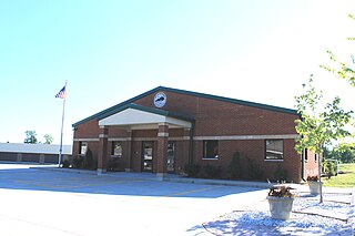
McCracken County is a county located in the far west portion of U.S. state of Kentucky. As of the 2020 census, the population was 67,875. The county seat and only municipality is Paducah. McCracken County was the 78th county formed in the state, having been created in 1825. It is part of the historic Jackson Purchase, territory sold by the Chickasaw people to General Andrew Jackson and Governor Isaac Shelby; this territory was located at the extreme western end of Kentucky.

<span class="mw-page-title-main">Carlisle County, Kentucky</span> County in Kentucky, United States

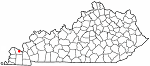
Carlisle County is a county located in the U.S. state of Kentucky. As of the 2020 census, the population was 4,826, making it the fourth-least populous county in Kentucky. Its county seat is Bardwell. The county was founded in 1886 and named for John Griffin Carlisle, a Speaker of the United States House of Representatives from Kentucky. It remains a prohibition or dry county. Carlisle County is included in the Paducah, KY-IL, Metropolitan Statistical Area.

<span class="mw-page-title-main">Barlow, Kentucky</span> City in Kentucky, United States

Barlow is a home rule-class city in Ballard County, Kentucky, in the United States. The city was formally incorporated by the state assembly in 1872 as Barlow City and later reincorporated in 1903. The population was 653 as of the 2020 census. It is part of the Paducah, KY-IL Metropolitan Statistical Area.

<span class="mw-page-title-main">Kevil, Kentucky</span> City in Kentucky, United States

Kevil is a home rule-class city in Ballard County, Kentucky, United States. The population was 595 as of the 2020 census, It is part of the Paducah KY-IL Metropolitan Statistical Area.

<span class="mw-page-title-main">Irvington, Kentucky</span> City in Kentucky, United States

Irvington is a home rule-class city in Breckinridge County, Kentucky, in the United States. The population was 1,181 at the 2010 census.

<span class="mw-page-title-main">Rochester, Kentucky</span> City in Kentucky

Rochester is a home rule-class city in Butler County, Kentucky, United States, at the confluence of the Green and Mud rivers. The population was 114 as of the 2020 Census

<span class="mw-page-title-main">Arlington, Kentucky</span> City in Kentucky, United States

Arlington is a home rule-class city in Carlisle County, Kentucky, in the United States. The population was 324 at the 2010 census, a drop from 395 in 2000. It was formally incorporated by the state assembly in 1876. Arlington is included in the Paducah, KY-IL Metropolitan Statistical Area.

<span class="mw-page-title-main">Oak Grove, Kentucky</span> City in Kentucky, United States

Oak Grove is a home rule-class city adjacent to the Fort Campbell army base in Christian County, Kentucky, in the United States. The population was 7,931 as of the 2020 census, up from 7,489 as of the 2010 U.S. Census. It is part of the Clarksville, Tennessee metropolitan area.

<span class="mw-page-title-main">Marion, Kentucky</span> City in Kentucky, United States

Marion is a home rule-class city in Crittenden County, Kentucky, in the United States. It is the seat of its county. As of the 2010 census, the city population was 3,039.

<span class="mw-page-title-main">Crittenden, Kentucky</span> City in Kentucky, United States

Crittenden is a home rule-class city in Grant and Kenton counties, Kentucky, in the United States. The population was 4,023 as of the 2020 Census, up from 3,815 as of the 2010 census, which was further up from 2,401 at the 2000 census.

<span class="mw-page-title-main">Caneyville, Kentucky</span> City in Kentucky, United States

Caneyville is a home rule-class city in Grayson County, Kentucky, in the United States. The population was 608 at the 2010 census. Named for its location on Caney Creek, Caneyville had a post office by 1837 and a town charter by 1840 and was incorporated by the state legislature in 1880.

<span class="mw-page-title-main">Columbus, Kentucky</span> City in Kentucky, United States

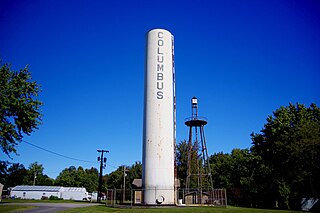
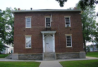
Columbus is a home rule-class city in Hickman County, Kentucky, in the United States. The population was 170 at the 2010 census, a decline from 229 in 2000. The city lies at the western end of the state, less than a mile from the Mississippi River.

<span class="mw-page-title-main">Blaine, Kentucky</span> City in Kentucky, United States

Blaine is a home rule-class city in Lawrence County, Kentucky, United States. The population was 47 at the 2010 census, down from 245 at the 2000 census.

<span class="mw-page-title-main">Kuttawa, Kentucky</span> City in Kentucky, United States

Kuttawa is a home rule-class city in Lyon County, Kentucky, in the United States. The population was 649 as of the 2010 census, up from 596 in 2000.

<span class="mw-page-title-main">Hendron, Kentucky</span> Census-designated place in Kentucky, United States

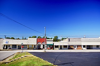
Hendron is an unincorporated community and census-designated place (CDP) in McCracken County, Kentucky, United States. The population was 4,774 at the 2020 census. It is part of the Paducah, KY-IL Metropolitan Statistical Area.

<span class="mw-page-title-main">Edmonton, Kentucky</span> City in Kentucky, United States

Edmonton is a home rule-class city in and the county seat of Metcalfe County, Kentucky, United States. It is part of the Glasgow Micropolitan Statistical Area. The population was 1,671 at the 2020 census.

<span class="mw-page-title-main">Elkhorn City, Kentucky</span> City in Kentucky, United States

Elkhorn City is a home rule-class city in Pike County, Kentucky, in the United States. The population was 1,035 at the 2020 census. The city is located in proximity to the Breaks Interstate Park.

<span class="mw-page-title-main">Jamestown, Kentucky</span> City in Kentucky, United States

Jamestown is a home rule-class city in Russell County, Kentucky, in the United States. It is the seat of its county. The population was 1,794 at the 2010 U.S. census.

<span class="mw-page-title-main">Pleasureville, Kentucky</span> City in Kentucky, United States

Pleasureville is a home rule-class city in Henry and Shelby counties, Kentucky, United States. The population was 834 at the time of the 2010 U.S. Census.

Bandana is a census-designated place (CDP) in Ballard County, Kentucky, United States. As of the 2020 census it had a population of 177.

References

  1. "2020 U.S. Gazetteer Files". United States Census Bureau. Retrieved March 18, 2022.
  2. "Find a County". National Association of Counties. Archived from the original on May 31, 2011. Retrieved June 7, 2011.
  3. Commonwealth of Kentucky. Office of the Secretary of State. Land Office. "Bardwell, Kentucky". Accessed 15 July 2013.
  4. Rennick, Robert M. (August 28, 2013). Kentucky Place Names. University Press of Kentucky. p. 57. ISBN   978-0-8131-4401-6.
  5. Lovey Rayburn. National Register of Historic Places Inventory/Nomination: Illinois Central Railroad Station and Freight Depot. National Park Service, 1976-06-01, 3.
  6. Rennick, Robert M. (August 28, 2013). Kentucky Place Names. University Press of Kentucky. p. 8. ISBN   978-0-8131-4401-6.
  7. "US Gazetteer files: 2010, 2000, and 1990". United States Census Bureau. February 12, 2011. Retrieved April 23, 2011.
  8. "Geographic Identifiers: 2010 Demographic Profile Data (G001): Bardwell city, Kentucky". U.S. Census Bureau, American Factfinder. Archived from the original on February 12, 2020. Retrieved August 6, 2014.
  9. "Census of Population and Housing". Census.gov. Retrieved June 4, 2015.
  10. "U.S. Census website". United States Census Bureau . Retrieved January 31, 2008.
  11. Climate Summary for Paris, Missouri