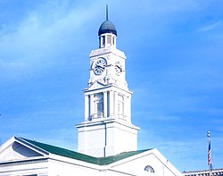
Winchester, Kentucky | |
---|---|
Motto(s): Rich in History and Ready for the Future | |
Coordinates: 37°59′41″N84°11′3″W / 37.99472°N 84.18417°W | |
Country | United States |
State | Kentucky |
County | Clark |
Area | |
• Total | 9.25 sq mi (23.97 km2) |
• Land | 9.15 sq mi (23.70 km2) |
• Water | 0.10 sq mi (0.27 km2) |
Elevation | 994 ft (303 m) |
Population (2020) | |
• Total | 19,134 |
• Estimate (2022) [2] | 19,142 |
• Density | 2,090.92/sq mi (807.31/km2) |
Time zone | UTC−5 (Eastern (EST)) |
• Summer (DST) | UTC−4 (EDT) |
ZIP codes | 40391-40392 |
Area code | 859 |
FIPS code | 21-83676 |
GNIS feature ID | 0506924 |
Website | winchesterky |
Winchester is a home rule-class city in and the county seat of Clark County, Kentucky, United States. [3] The population was 19,134 at the 2020 census. [4] It is part of the Lexington-Fayette, KY Metropolitan Statistical Area. Winchester is located roughly halfway between Lexington and Mt. Sterling.
It was named after Winchester, Virginia. [5]
Winchester is located northwest of the center of Clark County, 18 miles (29 km) east of Lexington and 15 miles (24 km) west of Mt. Sterling. Kentucky Route 1958 (Bypass Road) is an outer loop around the town. Kentucky Route 627 (Boonesborough Road) leads towards Richmond, 21 miles (34 km) to the south and Paris to the north. U.S. Route 60 (Winchester-Lexington Road/Lexington Avenue) runs through downtown Winchester. Interstate 64 passes through the northern part of the city, with access from exits 94 and 96. The Mountain Parkway turns off I-64 just northeast of Winchester and leads 75 miles (121 km) east to Salyersville.
According to the United States Census Bureau, Winchester has a total area of 7.9 square miles (20.4 km2), of which 7.8 square miles (20.3 km2) is land and 0.04 square miles (0.1 km2), or 0.67%, is water. [4]
The climate in this area is characterized by hot, humid summers and generally mild to cool winters. According to the Köppen Climate Classification system, Winchester has a humid subtropical climate, abbreviated "Cfa" on climate maps. [6]
Census | Pop. | Note | %± |
---|---|---|---|
1800 | 130 | — | |
1810 | 538 | 313.8% | |
1830 | 620 | — | |
1840 | 1,047 | 68.9% | |
1860 | 1,142 | — | |
1870 | 1,616 | 41.5% | |
1880 | 2,277 | 40.9% | |
1890 | 4,519 | 98.5% | |
1900 | 5,964 | 32.0% | |
1910 | 7,156 | 20.0% | |
1920 | 8,333 | 16.4% | |
1930 | 8,233 | −1.2% | |
1940 | 8,594 | 4.4% | |
1950 | 9,226 | 7.4% | |
1960 | 10,187 | 10.4% | |
1970 | 13,402 | 31.6% | |
1980 | 15,216 | 13.5% | |
1990 | 15,799 | 3.8% | |
2000 | 16,724 | 5.9% | |
2010 | 18,368 | 9.8% | |
2020 | 19,134 | 4.2% | |
2022 (est.) | 19,142 | [7] | 0.0% |
U.S. Decennial Census [8] |
As of the census [9] of 2000, there were 16,724 people, 6,907 households, and 4,620 families residing in the city. The population density was 2,187.6 per square mile (844.6/km2). There were 7,400 housing units at an average density of 968.0 per square mile (373.7/km2). The racial makeup of the city was 88.94% White, 8.83% African American, 0.22% Native American, 0.25% Asian, 0.01% Pacific Islander, 0.81% from other races, and 0.94% from two or more races. Hispanic or Latino of any race were 1.60% of the population.
There were 6,907 households, out of which 31.4% had children under the age of 18 living with them, 47.0% were married couples living together, 16.4% had a female householder with no husband present, and 33.1% were non-families. 28.5% of all households were made up of individuals, and 12.6% had someone living alone who was 65 years of age or older. The average household size was 2.39 and the average family size was 2.93.
In the city, the population was spread out, with 24.9% under the age of 18, 9.9% from 18 to 24, 30.0% from 25 to 44, 21.1% from 45 to 64, and 14.0% who were 65 years of age or older. The median age was 35 years. For every 100 females, there were 88.7 males. For every 100 females age 18 and over, there were 84.4 males.
The median income for a household in the city was $31,254, and the median income for a family was $36,797. Males had a median income of $31,295 versus $21,747 for females. The per capita income for the city was $15,611. About 13.1% of families and 15.5% of the population were below the poverty line, including 21.1% of those under age 18 and 14.4% of those age 65 or over.
Winchester's top 10 employers in manufacturing, service, and technology (2016) [10] | ||
Employer | Number of employees | Year established in Winchester |
---|---|---|
Fayette Electrical Service, Inc. | 105 | 2019 |
Catalent Pharma | 400 | 1992 |
East Kentucky Power Cooperative | 300 | 1941 |
General Dynamics Information Technology | 208 | 2014 |
Infiltrator Water Technologies | 182 | 1986 |
Leggett & Platt | 250 | 1910 |
Save-A-Lot Distribution Center | 210 | 1998 |
The Freeman Corporation | 223 | 1913 |
Walle Corporation | 140 | 1991 |
Winchester Farms Dairy | 183 | 1982 |
Ale-8-One, a Kentucky-specific brand of soft drink, has been bottled in Winchester since 1926. [11]
Winchester is home to the Beer Cheese Festival held annually in June. Beer Cheese was developed in Clark County near Winchester in the 1940s. [12]
Oliver High School was in Winchester. Berea graduate G. A. Benton was principal. [13]
Winchester students attend George Rogers Clark High School, located southwest of Winchester in Clark County. [14]
Winchester has been home to several higher education establishments. Kentucky Wesleyan College was located in the city from 1890 to 1954. When Kentucky Wesleyan left, the local Churches of Christ organized Southeastern Christian College on the former Kentucky Wesleyan campus. After Southeastern Christian College folded in 1979, the campus was preserved as a public park. Today, Clark County is home to the Winchester Campus of Bluegrass Community and Technical College.
Winchester has a lending library, the Clark County Public Library. [15]
Interstate 64 runs east–west through the northern part of Winchester. U.S. Route 60 runs east–west through Winchester. Kentucky Route 627 runs north–south through Winchester.
Blue Grass Airport, 29 miles to the west, in the western part of Lexington, is one of the busiest commercial airports in the state.
The Louisville and Nashville Railroad had run trains east–west and north–south through Winchester. The last L&N passenger train was an unnamed Cincinnati - Atlanta remnant of the former Cincinnati - Jacksonville Flamingo; it was discontinued on March 7, 1968. [16] [17]
A 2018 episode of The Dead Files was filmed in Winchester. [25]
Winchester has two sister cities, as designated by Sister Cities International:
Shelby County is a county located in the U.S. state of Kentucky. As of the 2020 census, the population was 48,065. Its county seat is Shelbyville. The county was established in 1792 and named for Isaac Shelby, the first Governor of Kentucky. Shelby County is part of the Louisville/Jefferson County, KY–IN Metropolitan Statistical Area. Shelby County's motto is "Good Land, Good Living, Good People".
Fayette County is a county located in the central part of the U.S. state of Kentucky and is consolidated with the city of Lexington. As of the 2020 census, the population was 322,570, making it the second-most populous county in the commonwealth. Since 1974, its territory, population and government have been shared with Lexington. Fayette County is part of the Lexington-Fayette, KY Metropolitan Statistical Area.
Clark County is a county located in the U.S. state of Kentucky. As of the 2020 census, the population was 36,972. Its county seat is Winchester. The county was created in 1792 from Bourbon and Fayette counties and is named for Revolutionary War hero George Rogers Clark. Clark County is part of the Lexington-Fayette, KY Metropolitan Statistical Area.
Scottsburg is a city within Vienna Township and the county seat of Scott County, in the U.S. state of Indiana, about 30 miles (48 km) north of Louisville, Kentucky. The population of Scottsburg was 7,345 at the 2020 census.
Irvington is a home rule-class city in Breckinridge County, Kentucky, in the United States. The population was 1,181 at the 2010 census.
Shepherdsville is a home rule-class city on the Salt River in Bullitt County, Kentucky, in the United States. It is the second largest city and seat of its county, located just south of Louisville. The population was 14,201 during the 2020 U.S. Census.
Lancaster is a home rule-class city in Garrard County, Kentucky, in the United States. It is the seat of its county. As of the year 2020 U.S. census, the city population was 3,901.
Jeffersontown is a home rule-class city in Jefferson County, Kentucky, United States. The population was 28,474 at the 2020 census.
Lyndon is a home rule-class city in Jefferson County, Kentucky, United States. The population was 11,002 at the 2010 census, up from 9,369 at the 2000 census.
Middletown is an independent, home rule-class city in Jefferson County, Kentucky, United States, and a suburb of Louisville. The population was 7,218 at the 2010 census.
Stanford is a home rule-class city in Lincoln County, Kentucky, United States. It is one of the oldest settlements in Kentucky, having been founded in 1775. Its population was 3,487 at the 2010 census and an estimated 3,686 in 2018. It is the county seat of Lincoln County. Stanford is part of the Danville Micropolitan Statistical Area.
Richmond is a home class city in Kentucky and the county seat of Madison County, Kentucky, United States. It is named after Richmond, Virginia, and is home to Eastern Kentucky University. The population was 38,030 as of 2024. Richmond is the fourth-largest city in the Bluegrass region and the state's seventh-largest city. It is the ninth largest population center in the state with a Micropolitan population of 106,864. The city serves as the center for work and shopping for south-central Kentucky, with many local and chain options alike. Richmond KY is home to numerous festivals, notably the Millstone Festival. In addition, Richmond is the principal city of the Richmond-Berea, Kentucky Micropolitan Area, which includes all of Madison and Rockcastle counties.
Calhoun is a home rule-class city in McLean County, Kentucky, United States. The population was 725 at the 2020 census. It is the county seat of McLean County. It is included in the Owensboro, Kentucky Metropolitan Statistical Area.
Mount Sterling, often written as Mt. Sterling, is a home rule-class city in Montgomery County, Kentucky, United States. The population was 7,558 as of the 2020 census, up from 6,895 in 2010. It is the county seat of Montgomery County and the principal city of the Mount Sterling micropolitan area.
Bardstown is a home rule-class city in Nelson County, Kentucky, United States. The population was 13,567 in the 2020 census. It is the county seat of Nelson County.
Crestwood is a home rule-class city in Oldham County, Kentucky, United States just outside Louisville's Northeast End. The population was 6,183 as of the 2020 census. CNN listed it as the 52nd best place to live in America in 2005.
Hazard is a home rule-class city in, and the county seat of, Perry County, Kentucky, United States. The population was 5,263 at the 2020 census.
Elkton is a home rule-class city in and the county seat of Todd County, Kentucky, United States. The population was 2,062 at the 2010 census.
Pleasureville is a home rule-class city in Henry and Shelby counties, Kentucky, United States. The population was 834 at the time of the 2010 U.S. Census.
Prospect is a home rule-class city in Jefferson and Oldham counties in the U.S. state of Kentucky. The Jefferson County portion is a part of the Louisville Metro government. The population was 4,592 as of the 2020 census, down from 4,698 at the time of the 2010 census. It is one of the wealthiest communities in Kentucky.
Media related to Winchester, Kentucky at Wikimedia Commons