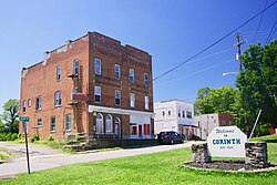
Corinth, Kentucky

Last updated

Corinth, Kentucky
Corinth-Main-St-ky.jpg
Main Street
Scott County Kentucky Incorporated and Unincorporated areas Corinth Highlighted 2117434.svg
Location of Corinth in Scott County, Kentucky.
Coordinates: 38°30′24″N84°36′52″W / 38.50667°N 84.61444°W / 38.50667; -84.61444
Country United States
State Kentucky
Counties Grant, Scott
Founded1868 [1]
Government
  Type Mayor–council [2]
   Mayor Billy Hill [2]
  Commissioner
Commissioners [3]
  • Aimee Lingle(vice Mayor)
  • Barb New
  • Deanna Caldwell
  • Jenette Houk
   City Clerk/Treasurer Tara Wright [3]
   City Attorney April Gatlin [3]
Area
[4]
  Total2.13 sq mi (5.53 km2)
  Land2.12 sq mi (5.48 km2)
  Water0.02 sq mi (0.04 km2)
Elevation
[5]
883 ft (269 m)
Population
 (2020)
  Total226
  Density106.70/sq mi (41.21/km2)
Time zone UTC-5 (Eastern (EST))
  Summer (DST) UTC-4 (EDT)
ZIP code
41010
Area code 859
FIPS code 21-17434
GNIS feature ID2404131 [5]
Website corinth.ky.gov

Corinth is a home rule-class city mostly in Grant County with a small portion of land in Scott County in the U.S. state of Kentucky. The population was 232 as of the 2010 census, [6] up from 181 at the 2000 census. [7]

Contents

The Grant County portion of Corinth is part of the Cincinnati-Middletown, OH KY IN Metropolitan Statistical Area, while the Scott County portion is part of the Lexington-Fayette Metropolitan Statistical Area.

History

The Corinth community began in the late 1820s with the founding of Corinth Christian Church, but the post office was not established until 1868. [1] The town most likely got its name from the church. [8] In 1871, the church relocated to a new site, and in 1873-74 and new church was built, replacing the log church. Until 1876, much of Corinth was in Owen County. In 1876, it was transferred to Grant County. [1] In 1878, Corinth was incorporated by the Kentucky State Legislature, which, in the same year, chartered the Corinth Academy. In 1890, the first of four fires occurred. The salvage of the train depot and three residences is credited to a passing train's boiler water. [1] The fires of 1904 and 1914 were on a similar scale. The Corinth basketball team won the 1930 state and national championships. [9] In 1933, another fire destroyed much of the central business district, but help from other fire departments contained the fire. [1] Much of the destruction was caused by lack of water. Steps to minimize this were taken in 1986 with the creation of the Corinth Water District. In 1995, the city obtained a grant/loan package to establish a water treatment plant in Corinth. [1]
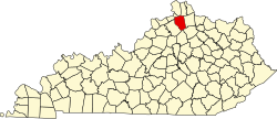
Geography

Corinth is located in southern Grant County. U.S. Route 25 passes through the center of town, leading north 11 miles (18 km) to Williamstown, the Grant County seat, and south 22 miles (35 km) to Georgetown, the Scott County seat. Interstate 75 crosses the city limits briefly, 1.5 miles (2.4 km) west of the center, at Exit 144 (Kentucky Route 330). I-75 leads north 48 miles (77 km) to Cincinnati and south 34 miles (55 km) to Lexington. KY 330 leads west 21 miles (34 km) to Owenton and northeast 22 miles (35 km) to Falmouth.

According to the United States Census Bureau, Corinth has a total area of 2.1 square miles (5.5 km2), of which 0.02 square miles (0.04 km2), or 0.79%, is water. [6]

Demographics

Historical population
CensusPop.Note
1900 331
1910 252−23.9%
1920 241−4.4%
1930 32836.1%
1940 210−36.0%
1950 28334.8%
1960 238−15.9%
1970 236−0.8%
1980 2589.3%
1990 137−46.9%
2000 18132.1%
2010 23228.2%
2020 226−2.6%
U.S. Decennial Census [10]

As of the census [7] of 2000, there were 181 people, 75 households, and 44 families residing in the city. The population density was 507.7 inhabitants per square mile (196.0/km2). There were 87 housing units at an average density of 244.0 per square mile (94.2/km2). The racial makeup of the city was 99.45% White and 0.55% African American.

There were 75 households, out of which 33.3% had children under the age of 18 living with them, 45.3% were married couples living together, 10.7% had a female householder with no husband present, and 41.3% were non-families. 41.3% of all households were made up of individuals, and 21.3% had someone living alone who was 65 years of age or older. The average household size was 2.41 and the average family size was 3.34.

In the city the population was spread out, with 32.6% under the age of 18, 8.8% from 18 to 24, 23.8% from 25 to 44, 18.8% from 45 to 64, and 16.0% who were 65 years of age or older. The median age was 33 years. For every 100 females, there were 86.6 males. For every 100 females age 18 and over, there were 82.1 males.

The median income for a household in the city was $23,750, and the median income for a family was $27,750. Males had a median income of $28,125 versus $22,917 for females. The per capita income for the city was $10,952. About 29.8% of families and 32.2% of the population were below the poverty line, including 34.5% of those under the age of eighteen and 37.8% of those 65 or over.

Religion

There are six churches in Corinth: [11]

Related Research Articles

<span class="mw-page-title-main">Owen County, Kentucky</span> County in Kentucky, United States

Owen County is a county located in the northern part of the U.S. state of Kentucky. Its county seat is Owenton. The county is named for Colonel Abraham Owen. It is a prohibition or dry county, with the exception of a winery that is authorized to sell its product to the public, and limited sales within the incorporated city limits of Owenton.

<span class="mw-page-title-main">LaRue County, Kentucky</span> County in Kentucky, United States

LaRue County is a county in the central region of the U.S. state of Kentucky, outside the Bluegrass Region and larger population centers. As of the 2020 census, the population was 14,867. Its county seat is Hodgenville, which is best known as the birthplace of United States President Abraham Lincoln. The county was established on March 4, 1843, from the southeast portion of Hardin County. It was named for John P. LaRue, an early settler. LaRue County is included in the Elizabethtown-Fort Knox, KY Metropolitan Statistical Area, which is also included in the Louisville/Jefferson County-Elizabethtown-Bardstown, KY-IN Combined Statistical Area. It is a dry county.

<span class="mw-page-title-main">Hickman County, Kentucky</span> County in Kentucky, United States

Hickman County is a county located in the U.S. state of Kentucky. As of the 2020 census, the population was 4,521, making it the third-least populous county in Kentucky. Its county seat is Clinton. The county was formed in 1821. It is the least densely populated county in the state and is a prohibition or dry county.

<span class="mw-page-title-main">Grant County, Kentucky</span> County in Kentucky, United States

Grant County is a county located in the northern part of the U.S. state of Kentucky. As of the 2020 census, the population was 24,941. Its county seat is Williamstown. The county was formed in 1820 and named for Colonel John Grant, who led a party of settlers in 1779 to establish Grant's Station, in today's Bourbon County, Kentucky. Grant County is included in the Cincinnati-Middletown, OH-KY-IN Metropolitan Statistical Area. Grant County residents voted to allow full alcohol sales in the county by a margin of 56% to 44% in a special election on December 22, 2015. In the 19th century, Grant County had multiple saloons.

<span class="mw-page-title-main">Fayette County, Kentucky</span> County in Kentucky, United States

Fayette County is located in the central part of the U.S. state of Kentucky. As of the 2020 census, the population was 322,570, making it the second-most populous county in the commonwealth. Its territory, population and government are coextensive with the city of Lexington, which also serves as the county seat. Fayette County is part of the Lexington–Fayette, KY Metropolitan Statistical Area.

<span class="mw-page-title-main">Hamilton, Georgia</span> City in Georgia, United States

Hamilton is a city in, and the county seat of Harris County, Georgia, United States. It is part of the Columbus, Georgia-Alabama Metropolitan Statistical Area. The population was 1,680 at the 2020 census, up from 307 at the 2000 census. As of 2020 the population had risen to an estimated 1780.

<span class="mw-page-title-main">Hardinsburg, Kentucky</span> City in Kentucky, United States

Hardinsburg is a home rule-class city in Breckinridge County, Kentucky, in the United States. It is the seat of its county. The population was 2,343 at the 2010 census. Hardinsburg was named after Captain William Hardin.

<span class="mw-page-title-main">Mount Washington, Kentucky</span> City in Kentucky, United States

Mount Washington is a home rule-class city in northeast Bullitt County, Kentucky, in the United States. The population was 18,090 at the 2020 census. The city is one of several surrounding Louisville that have experienced a sharp rise in population in the past three decades, becoming a commuter town.

<span class="mw-page-title-main">Wilder, Kentucky</span> City in Kentucky, United States

Wilder is a home rule-class city in Campbell County, Kentucky, United States. The population was 3,035 at the 2010 census. It is part of the Cincinnati-Northern Kentucky metropolitan area.

<span class="mw-page-title-main">Fulton, Kentucky</span> City in Kentucky, United States

Fulton is a home rule-class city in Fulton County, Kentucky, United States. The population was 2,357 at the 2020 census, down from 2,445 at the 2010 census. It was once known as the "Banana Capital of the World", because 70% of imported bananas to the U.S. used to be shipped through the city. Fulton is part of the Union City-Hickman, TN–KY Micropolitan Statistical Area.

<span class="mw-page-title-main">Dry Ridge, Kentucky</span> City in Kentucky, United States

Dry Ridge is a home rule-class city in Grant County, Kentucky, in the United States. The population was 2,191 at the 2010 census, up from 1,995 at the 2000 census. From around 1910 to 1960, the city's economy was dominated by business related to its mineral water wells, purported to have healing properties.

<span class="mw-page-title-main">Greenup, Kentucky</span> City in Kentucky, United States

Greenup is a home rule-class city located at the confluence of the Little Sandy River with the Ohio River in Greenup County, Kentucky, United States. The population was 1,188 at the 2010 census. Greenup is one of three county seats in the Commonwealth of Kentucky to share its name with its county; the other two being Harlan and Henderson.

<span class="mw-page-title-main">Wallins Creek, Kentucky</span> Census-designated place in Kentucky, United States

Wallins Creek is an unincorporated community and census-designated place (CDP) in Harlan County, Kentucky, United States. The population was 156 at the 2010 census, when it was still a city, having dropped from 257 at the 2000 census.

<span class="mw-page-title-main">Columbus, Kentucky</span> City in Kentucky, United States

Columbus is a home rule-class city in Hickman County, Kentucky, in the United States. The population was 170 at the 2010 census, a decline from 229 in 2000. The city lies at the western end of the state, less than a mile from the Mississippi River.

<span class="mw-page-title-main">Hanson, Kentucky</span> City in Kentucky, United States

Hanson is a home rule-class city in Hopkins County, Kentucky, in the United States. The population was 742 at the 2010 census, up from 625 at the 2000 census.

<span class="mw-page-title-main">Stanford, Kentucky</span> City in Kentucky, United States

Stanford is a home rule-class city in Lincoln County, Kentucky, United States. It is one of the oldest settlements in Kentucky, having been founded in 1775. Its population was 3,487 at the 2010 census and an estimated 3,686 in 2018. It is the county seat of Lincoln County. Stanford is part of the Danville Micropolitan Statistical Area.

<span class="mw-page-title-main">Gamaliel, Kentucky</span> City in Kentucky, United States

Gamaliel is a home rule-class city in Monroe County, Kentucky, in the United States. The population was 391 at the 2020 census.

<span class="mw-page-title-main">Beaver Dam, Kentucky</span> City in Kentucky, United States

Beaver Dam is a home rule-class city in Ohio County, Kentucky, in the United States. The population was 3,409 at the 2010 census, and it is the most populous community in the county. It is named for the Beaver Dam Baptist Church which predates the town by several decades. The city was formally incorporated by the state assembly in 1873.

<span class="mw-page-title-main">Williamsburg, Kentucky</span> City in Kentucky, United States

Williamsburg is a home rule-class city in and the county seat of Whitley County, on the southeastern border of Kentucky, United States. The population was 5,245 at the 2010 census. Developed along the Cumberland River, the city was founded in 1818 and named after William Whitley.

<span class="mw-page-title-main">Williamstown, Kentucky</span> City in Kentucky, United States

Williamstown is a home-rule-class city in Grant and Pendleton counties in the U.S. state of Kentucky. The population was 3,925 at the 2010 census, up from 3,227 as of the 2000 census. It is the county seat of Grant County.

References

  1. 1 2 3 4 5 6 Corinth, City of (September 1, 2009). "Kentucky: The City of Corinth - History". Kentucky, Commonwealth of. Archived from the original on April 9, 2010. Retrieved April 6, 2010.
  2. 1 2 Corinth, City of (September 1, 2009). "Kentucky: The City of Corinth - Home". Kentucky, Commonwealth of. Retrieved April 6, 2010.
  3. 1 2 3 Corinth, City of (September 1, 2009). "Kentucky: The City of Corinth - City Commission". Kentucky, Commonwealth of. Archived from the original on April 9, 2010. Retrieved April 6, 2010.
  4. "2020 U.S. Gazetteer Files". United States Census Bureau. Retrieved March 18, 2022.
  5. 1 2 U.S. Geological Survey Geographic Names Information System: Corinth, Kentucky
  6. 1 2 "Geographic Identifiers: 2010 Demographic Profile Data (G001): Corinth city, Kentucky". American Factfinder. U.S. Census Bureau. Retrieved December 6, 2016.[ dead link ]
  7. 1 2 "U.S. Census website". United States Census Bureau . Retrieved January 31, 2008.
  8. Kentucky, University of (February 24, 2004). "Corinth, Kentucky". Kentucky Atlas & Gazetteer. Retrieved April 6, 2010.
  9. Corinth, City of (September 1, 2009). "Kentucky: The City of Corinth - State Basketball Championship". Kentucky, Commonwealth of. Archived from the original on April 9, 2010. Retrieved April 6, 2010.
  10. "Census of Population and Housing". Census.gov. Retrieved June 4, 2015.
  11. Corinth, City of (September 1, 2009). "Kentucky: The City of Corinth - Places of Worship". Kentucky, Commonwealth of. Archived from the original on April 9, 2010. Retrieved April 6, 2010.
  12. Southern Baptist Convention (2010). "Lawrenceville Baptist Church - Southern Baptist Church". Archived from the original on March 3, 2016. Retrieved April 6, 2010.
  13. Southern Baptist Convention (2010). "New Columbus Baptist Church - Southern Baptist Church". Archived from the original on March 3, 2016. Retrieved April 6, 2010.
  14. United Methodist Church. "Find-A-Church: New Columbus" . Retrieved April 6, 2010.