Downingsville, Kentucky

Last updated

Downingsville is an unincorporated community in Grant County, Kentucky, in the United States. [1]

Grant County, Kentucky U.S. county in Kentucky

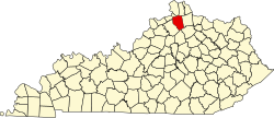
Grant County is a county located in the U.S. state of Kentucky. As of the 2010 census, the population was 24,662. Its county seat is Williamstown. The county was formed in 1820 and named for Colonel John Grant, who led a party of settlers in 1779 to establish Grant's Station, in today's Bourbon County, Kentucky.

United States Federal republic in North America

The United States of America (USA), commonly known as the United States or America, is a country comprising 50 states, a federal district, five major self-governing territories, and various possessions. At 3.8 million square miles, the United States is the world's third or fourth largest country by total area and is slightly smaller than the entire continent of Europe. With a population of over 327 million people, the U.S. is the third most populous country. The capital is Washington, D.C., and the most populous city is New York City. Most of the country is located contiguously in North America between Canada and Mexico.

History

A post office called Downingsville was established in 1844, and remained in operation until it was discontinued in 1909. [2] In the 1870s, business enterprises in Downingsville included a hotel, a gristmill and a sawmill. [3]

Related Research Articles

Glencoe, Kentucky City in Kentucky, United States

Glencoe is a home rule-class city in Gallatin County, Kentucky, in the United States. The population was 360 as of the 2010 census, up from 251 at the 2000 census.

Corinth, Kentucky City in Kentucky, United States

Corinth is a home rule-class city mostly in Grant County with a small portion of land in Scott County in the U.S. state of Kentucky. The population was 232 as of the 2010 census, up from 181 at the 2000 census.

Rzuski Las Village in Pomeranian Voivodeship, Poland

Rzuski Las is a village in the administrative district of Gmina Główczyce, within Słupsk County, Pomeranian Voivodeship, in northern Poland. It lies approximately 5 kilometres (3 mi) north-east of Główczyce, 33 km (21 mi) north-east of Słupsk, and 84 km (52 mi) west of the regional capital Gdańsk.

Connersville is an unincorporated community in Harrison County, Kentucky, in the United States.

Stony Point is an unincorporated community in Bourbon County, Kentucky, in the United States.

Sherman is an unincorporated community in Grant County, Kentucky, in the United States.

Antioch is an unincorporated community in Harrison County, Kentucky, in the United States.

Colemansville is an unincorporated community in Harrison County, Kentucky, in the United States.

Boyd is an unincorporated community in Harrison County, Kentucky, in the United States.

Lees Lick is an unincorporated community in Harrison County, Kentucky, in the United States.

Rutland is an unincorporated community in Harrison County, Kentucky, in the United States.

Cordova is an unincorporated community in Grant County, in the U.S. state of Kentucky.

Wilmot, Indiana Unincorporated community in Indiana, United States

Wilmot is an unincorporated community in Washington Township, Noble County, in the U.S. state of Indiana.

Edgoten is an unincorporated community in Christian County, in the U.S. state of Kentucky.

Beasley Run is a stream in the U.S. state of Ohio. The 3.6-mile (5.8 km) long stream is a tributary of Sevenmile Creek.

Johnsville is an unincorporated community in Bracken County, in the U.S. state of Kentucky.

Milford is an unincorporated community in Bracken County, in the U.S. state of Kentucky.

Mystic is an unincorporated community in Pennington County, in the U.S. state of South Dakota.

Babcock is an unincorporated community in Miller County, in the U.S. state of Georgia.

References

  1. U.S. Geological Survey Geographic Names Information System: Downingsville, Kentucky
  2. "Grant County". Jim Forte Postal History. Archived from the original on 17 June 2015. Retrieved 4 January 2015.
  3. Collins, Lewis (1877). History of Kentucky. p. 290.

Coordinates: 38°38′30″N84°42′48″W / 38.64167°N 84.71333°W / 38.64167; -84.71333
Geographic coordinate system Coordinate system

A geographic coordinate system is a coordinate system that enables every location on Earth to be specified by a set of numbers, letters or symbols. The coordinates are often chosen such that one of the numbers represents a vertical position and two or three of the numbers represent a horizontal position; alternatively, a geographic position may be expressed in a combined three-dimensional Cartesian vector. A common choice of coordinates is latitude, longitude and elevation. To specify a location on a plane requires a map projection.