Blackey, Kentucky

Last updated

Blackey, Kentucky
Blackey Public Library.jpg
Blackey Public Library
Letcher County Kentucky Incorporated and Unincorporated areas Blackey Highlighted 2107012.svg
Location in Letcher County, Kentucky
Coordinates: 37°8′25″N82°58′46″W / 37.14028°N 82.97944°W / 37.14028; -82.97944
Country United States
State Kentucky
County Letcher
IncorporatedJanuary 27, 1915
Area
[1]
  Total0.45 sq mi (1.16 km2)
  Land0.44 sq mi (1.13 km2)
  Water0.01 sq mi (0.03 km2)
Elevation
1,007 ft (307 m)
Population
 (2020)
  Total109
  Density249.43/sq mi (96.27/km2)
Time zone UTC-5 (Eastern (EST))
  Summer (DST) UTC-4 (EDT)
ZIP code
41804
Area code 606
FIPS code 21-07012
GNIS feature ID0507346

Blackey is an unincorporated community [2] in Letcher County, Kentucky, in the United States. As of the 2010 census, the population was 120. [3] It is located near the early settlement of Indian Bottom. Blackey is thought to have been named after Blackey Brown, one of its citizens. [4]

Contents

History

The history of Blackey began in 1908, after local resident Jim Brown was given permission to establish a post office on Elk Creek. He decided to name the post office "Blackey", after his brother Joseph "Blackey" Brown. Due to the area's massive coal deposits, the Lexington and Eastern Railroad ran a line through Blackey in November 1912. Over the next fifteen years, Blackey was transformed from a sleepy mountain town to a bustling modern city. It was chartered in November 1912 and incorporated on January 27, 1915. [5] In 1913, the community became the home of the Stuart Robinson School, a Presbyterian settlement school that was to operate there until 1957. [6] In 1917, the Blackey Coal Company was established as the first coal company in the community. The company constructed thirty houses and employed eighty miners. [5]

In May 1927, a flash flood devastated the city. In one hour, the North Fork of the Kentucky River rose 18 feet (5.5 m), killing 26 people in Letcher County alone. Later in December a fire broke out, destroying most of the city's business district. Then in February 1928, another fire broke out and destroyed the rest of the town. Shortly afterwards, Blackey State Bank failed and the Great Depression ended the prosperity of the boom town. [5]

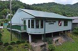
Today, Blackey is home to just over 150 people, with only a few abandoned buildings and a few occupied homes on Main Street. Within the last few years, the city has seen some revitalization consisting of a Head Start, a new city water system, and a public library. [5]

Geography

Blackey is located in western Letcher County at 37°8′25″N82°58′46″W / 37.14028°N 82.97944°W / 37.14028; -82.97944 (37.140413, -82.979368), [7] in the valley of the North Fork of the Kentucky River. Kentucky Route 7 passes through the town, leading west and northwest down the North Fork valley 19 miles (31 km) to Jeff, and northeast up the valley of Rockhouse Creek then north down the valley of the Right Fork of Beaver Creek 40 miles (64 km) to Wayland. Kentucky Route 588 leads south and east up the North Fork of the Kentucky 15 miles (24 km) to Whitesburg, the Letcher county seat.

According to the United States Census Bureau, the city of Blackey has a total area of 0.46 square miles (1.2 km2), of which 0.01 square miles (0.03 km2), or 2.72%, are water. [8]

Demographics

Historical population
CensusPop.Note
1920 269
1930 34929.7%
1940 54556.2%
1950 393−27.9%
2000 153
2010 120−21.6%
2020 109−9.2%
U.S. Decennial Census [9]

As of the census [10] of 2000, there were 153 people, 65 households, and 49 families residing in the city. The population density was 314.6 inhabitants per square mile (121.5/km2). There were 73 housing units at an average density of 150.1 per square mile (58.0/km2). The racial makeup of the city was 98.69% White and 1.31% from two or more races.

There were 65 households, out of which 23.1% had children under the age of 18 living with them, 60.0% were married couples living together, 10.8% had a female householder with no husband present, and 23.1% were non-families. 21.5% of all households were made up of individuals, and 6.2% had someone living alone who was 65 years of age or older. The average household size was 2.35 and the average family size was 2.66.

In the city, the population was spread out, with 17.0% under the age of 18, 11.8% from 18 to 24, 24.8% from 25 to 44, 34.0% from 45 to 64, and 12.4% who were 65 years of age or older. The median age was 42 years. For every 100 females, there were 86.6 males. For every 100 females age 18 and over, there were 95.4 males.

The median income for a household in the city was $19,250, and the median income for a family was $20,625. Males had a median income of $30,536 versus $21,875 for females. The per capita income for the city was $11,278. About 22.9% of families and 24.3% of the population were below the poverty line, including 28.1% of those under the age of eighteen and 33.3% of those 65 or over.

Education

Blackey has a lending library, a branch of the Letcher County Library. [11]

Arts and culture

Just across a small bridge is the C. B. Caudill Store & History Center, operated by Gaynell Begley. It was formerly a general store but has been converted into a history and community center. [12]

Related Research Articles

<span class="mw-page-title-main">Perry County, Kentucky</span> County in Kentucky, United States

Perry County is a county in the U.S. state of Kentucky. As of the 2020 census, the population was 28,473. Its county seat is Hazard. The county was founded in 1820. Both the county and county seat are named for Commodore Oliver Hazard Perry, a naval hero in the War of 1812.

<span class="mw-page-title-main">Letcher County, Kentucky</span> County in Kentucky, United States

Letcher County is a county located in the U.S. state of Kentucky. As of the 2020 census, the population was 21,548. Its county seat is Whitesburg. It was created in 1842 from Harlan and Perry counties, and named for Robert P. Letcher, Governor of Kentucky from 1840 to 1844.

<span class="mw-page-title-main">Knott County, Kentucky</span> County in Kentucky, United States

Knott County is a county located in the U.S. state of Kentucky. As of the 2020 census, the population was 14,251. Its county seat is Hindman. The county was formed in 1884 and is named for James Proctor Knott, Governor of Kentucky (1883–1887). It is a prohibition or dry county. Its county seat is home to the Hindman Settlement School, founded as America's first settlement school. The Knott County town of Pippa Passes is home to Alice Lloyd College.

<span class="mw-page-title-main">Cumberland, Kentucky</span> City in Kentucky, United States

Cumberland is a home rule-class city in Harlan County, Kentucky, in the United States. The population according to the 2010 Census was 2,237, down from 2,611 at the 2000 census.

<span class="mw-page-title-main">Evarts, Kentucky</span> City in Kentucky, United States

Evarts is a home rule-class city in Harlan County, Kentucky, in the United States. The post office was opened on February 9, 1855, and named for one of the area's pioneer families. The city was formally incorporated by the state assembly in 1921. The population was 962 at the 2010 census.

<span class="mw-page-title-main">Harlan, Kentucky</span> City in Kentucky, United States

Harlan is a home rule-class city in and the county seat of Harlan County, Kentucky, United States. The population was 1,745 at the 2010 census, down from 2,081 at the 2000 census.

<span class="mw-page-title-main">Hindman, Kentucky</span> City in Kentucky, United States

Hindman is a home rule-class town in, and the county seat of, Knott County, Kentucky, in the United States. The population was 777 at the 2010 U.S. census.

<span class="mw-page-title-main">Pippa Passes, Kentucky</span> City in Kentucky, United States

Pippa Passes is a home rule-class city located along Caney Fork in Knott County, eastern Kentucky, United States. Its formal name was chosen to honor benefactors of Alice Lloyd College. Residents commonly call the community "Caney" or "Caney Creek". The population was 533 at the 2010 census, up from 297 at the 2000 census. The small city is located in the mountainous Appalachia region, an area of coal mining.

<span class="mw-page-title-main">Louisa, Kentucky</span> City in Kentucky, United States

Louisa is a home-rule class city located in eastern Kentucky at the merger of the Levisa and Tug Forks into the Big Sandy River, which forms part of the state's border with West Virginia. It is the seat of Lawrence County. The population was 2,467 at the 2010 census and an estimated 2,375 in 2018.

<span class="mw-page-title-main">Hyden, Kentucky</span> City in Kentucky, United States

Hyden is a home rule-class city in and the county seat of Leslie County, Kentucky, United States. The population was 365 at the 2010 census. It is located at the junction of U.S. Route 421 and Kentucky Route 80, along the Middle Fork of the Kentucky River.

<span class="mw-page-title-main">Fleming-Neon, Kentucky</span> City in Kentucky, United States

Fleming-Neon also known as Neon, is a home rule-class city in Letcher County, Kentucky, in the United States. The population was 770 at the 2010 census, down from 840 at the 2000 census.

<span class="mw-page-title-main">Jenkins, Kentucky</span> City in Kentucky, United States

Jenkins is a home rule-class city in Letcher County, Kentucky, United States. The population was 2,203 as of the 2010 census.

<span class="mw-page-title-main">McRoberts, Kentucky</span> Census-designated place in Kentucky, United States

McRoberts is an unincorporated community and census-designated place (CDP) in Letcher County, Kentucky, United States. The population was 784 at the 2010 United States Census, down from 921 at the 2000 census. McRoberts is in the Eastern Kentucky Coalfield region.

<span class="mw-page-title-main">Whitesburg, Kentucky</span> City in Kentucky, United States

Whitesburg is a home rule-class city in and the county seat of Letcher County, Kentucky, United States. The population was 2,139 at the 2010 census and an estimated 1,875 in 2018. It was named for John D. White, a state politician.

<span class="mw-page-title-main">Warfield, Kentucky</span> City in Kentucky, United States

Warfield is a home rule-class city in Martin County, Kentucky, United States. The population was 264 at the 2020 census.

<span class="mw-page-title-main">New Haven, Kentucky</span> City in Kentucky, United States

New Haven is a home rule-class city in Nelson County, Kentucky, United States. The population was 855 at the 2010 census.

<span class="mw-page-title-main">Vicco, Kentucky</span> City in Kentucky, United States

Vicco is a Kentucky defunct city in Perry and Knott counties, Kentucky, United States as defined by Kentucky Act Acts Ch. 25. The population was 334 at the 2010 census.

<span class="mw-page-title-main">Elkhorn City, Kentucky</span> City in Kentucky, United States

Elkhorn City is a home rule-class city in Pike County, Kentucky, in the United States. The population was 982 at the 2010 census. The city is located in proximity to the Breaks Interstate Park.

<span class="mw-page-title-main">Keokee, Virginia</span> Census-designated place in Virginia, United States

Keokee is an unincorporated community and census-designated place (CDP) in Lee County, Virginia, United States. The population was 416 at the 2010 census.

<span class="mw-page-title-main">Williamstown, Kentucky</span> City in Kentucky, United States

Williamstown is a home-rule-class city in Grant and Pendleton counties in the U.S. state of Kentucky. The population was 3,925 at the 2010 census, up from 3,227 as of the 2000 census. It is the county seat of Grant County.

References

  1. "2020 U.S. Gazetteer Files". United States Census Bureau. Retrieved March 18, 2022.
  2. "Kentucky DLG - Counties View". kydlgweb.ky.gov. Retrieved February 1, 2022.
  3. "Total Population: 2010 Census DEC Summary File 1 (P1), Blackey city, Kentucky". data.census.gov. U.S. Census Bureau. Retrieved February 11, 2020.
  4. Blackey, Kentucky, Kentucky Atlas. Retrieved 18 May 2006.
  5. 1 2 3 4 History of Blackey, Kentucky Archived 2012-02-23 at the Wayback Machine Retrieved on 2010-04-10
  6. Helen Wykle (October 28, 2008), "Stuart Robinson School", Settlement Schools of the Southern Mountains, D.H. Ramsey Library, Special Collections, University of North Carolina Asheville, archived from the original on March 20, 2012, retrieved January 9, 2012
  7. "US Gazetteer files: 2010, 2000, and 1990". United States Census Bureau. February 12, 2011. Retrieved April 23, 2011.
  8. "U.S. Gazetteer Files: 2019: Places: Kentucky". U.S. Census Bureau Geography Division. Retrieved February 11, 2020.
  9. "Census of Population and Housing". Census.gov. Retrieved June 4, 2015.
  10. "U.S. Census website". United States Census Bureau . Retrieved January 31, 2008.
  11. "Kentucky Public Library Directory". Kentucky Department for Libraries and Archives. Archived from the original on January 11, 2019. Retrieved June 5, 2019.
  12. C.B. Caudill Store and History Center Archived 2007-06-25 at the Wayback Machine Retrieved on 2010-04-10