Hot Spot, Kentucky | |
|---|---|
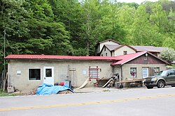 Former post office | |
 Hot Spot Location in Kentucky  Hot Spot Location in the United States | |
| Coordinates: 37°7′39″N82°55′0″W / 37.12750°N 82.91667°W | |
| Country | United States |
| State | Kentucky |
| County | Letcher |
| Elevation | 1,066 ft (325 m) |
| Time zone | UTC-5 (Eastern (EST)) |
| • Summer (DST) | UTC-4 (EDT) |
| ZIP code | 41845 [1] |
| Area code | 606 |
| GNIS feature ID | 494624 [2] |
Hot Spot is an unincorporated community and former coal town in Letcher County, Kentucky, United States. It was named for the Hot Spot Coal Company. Other names for the community have been Smoot Creek, Dalna, Elsiecoal, and Premium. It has frequently been noted on lists of unusual place names.