Dunham, Kentucky | |
|---|---|
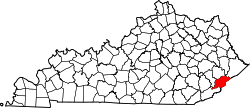
 Dunham Location in Kentucky  Dunham Location in the United States | |
| Coordinates: 37°11′24″N82°38′52″W / 37.19000°N 82.64778°W | |
| Country | United States |
| State | Kentucky |
| County | Letcher |
| Elevation | 1,594 ft (486 m) |
| Time zone | UTC-5 (Eastern (EST)) |
| • Summer (DST) | UTC-4 (EDT) |
| GNIS feature ID | 491314 [1] |
Dunham is an unincorporated community and coal town in Letcher County, Kentucky, United States. Dunham's post office [2] operated in the community from 1913 to 1960.
The community was named for county auditor A. S. Dunham. [3] The community contains two churches, a concrete supplier, and some scattered houses throughout the area. The community is governed by the nearby City of Jenkins, and sits roughly 5 minutes away from the Kentucky-Virginia border.