Burdine, Kentucky | |
|---|---|
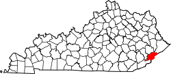
 Burdine Location in Kentucky  Burdine Location in the United States | |
| Coordinates: 37°11′21″N82°35′57″W / 37.18917°N 82.59917°W | |
| Country | United States |
| State | Kentucky |
| County | Letcher |
| Elevation | 1,483 ft (452 m) |
| Time zone | UTC-5 (Eastern (EST)) |
| • Summer (DST) | UTC-4 (EDT) |
| ZIP codes | 41517 |
| GNIS feature ID | 488407 [1] |
Burdine is an unincorporated community and coal town in Letcher County, Kentucky, United States. [2]
The Burdine post office was established on March 26, 1907, with Mary Ison as its postmaster. It closed in September 1911, and was re-established on March 30, 1912, with Melvin M. Martin as its postmaster. [3] The post office still serves the community with the ZIP code 41517. [4]