Deane, Kentucky

Last updated
Deane, Kentucky
USA Kentucky location map.svg
Red pog.svg
Deane
Location in Kentucky
Usa edcp location map.svg
Red pog.svg
Deane
Location in the United States
Coordinates: 37°14′19″N82°46′24″W / 37.23861°N 82.77333°W / 37.23861; -82.77333
Country United States
State Kentucky
County Letcher
Elevation
1,335 ft (407 m)
Time zone UTC-5 (Eastern (EST))
  Summer (DST) UTC-4 (EDT)
ZIP codes
41812
GNIS feature ID507826 [1]

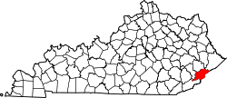
Deane is an unincorporated community located in Letcher County, Kentucky, United States. The community still operates a post office with the ZIP code 41812. [2]

Related Research Articles

<span class="mw-page-title-main">ZIP Code</span> Numeric postal code used in the United States and its territories

A ZIP Code is a system of postal codes used by the United States Postal Service (USPS). Introduced on July 1, 1963, the basic format consisted of five digits. In 1983, an extended ZIP+4 code was introduced; it included the five digits of the ZIP Code, followed by a hyphen and four digits that designated a more specific location.

Ermine is an unincorporated community in Letcher County, Kentucky, United States. Its ZIP Code is 41815.

Gays Creek is an unincorporated community in Perry County, Kentucky, United States. Gays Creek is 14 miles (23 km) west-northwest of Hazard. Gays Creek has a post office, established in 1888, with ZIP code 41745.

Huddy is an unincorporated community in Pike County, Kentucky. Huddy is located at the junction of U.S. Route 119 and Kentucky Route 199 15.5 miles (24.9 km) east-northeast of Pikeville. Huddy had a post office, which closed on January 22, 2011.

Belcher is an unincorporated community in Pike County, Kentucky. Belcher is located at the junction of U.S. Route 460 and Kentucky Route 80 2.9 miles (4.7 km) north-northwest of Elkhorn City. Belcher has a post office with ZIP code 41513.

Kimper is an unincorporated community in Pike County, Kentucky. Kimper is located at the junction of Kentucky Route 194 and Kentucky Route 632, 9.3 miles (15.0 km) east of Pikeville. Kimper has a post office with ZIP code 41539, which opened on August 8, 1919.

Kettle Island is an unincorporated community and coal town in Bell County, Kentucky, United States. Kettle Island is located on Kentucky Route 1630 near Kentucky Route 221, 5.35 miles (8.61 km) east-northeast of Pineville. Kettle Island has a post office with ZIP code 40958, which opened on March 15, 1912. The community also had a station on the Louisville and Nashville Railroad.

<span class="mw-page-title-main">Arjay, Kentucky</span> Unincorporated community in Kentucky, United States

Arjay is an unincorporated community and coal town in Bell County, Kentucky, United States. Arjay is located on Kentucky Route 66 4 miles (6.4 km) northeast of Pineville. Arjay has a post office with ZIP code 40902, which opened on February 23, 1911. The community's name comes from the initials of coal operator R. J. Asher.

Stoney Fork is an unincorporated community in Bell County, Kentucky, United States. Stoney Fork is located on Kentucky Route 221 10.1 miles (16.3 km) east-northeast of Pineville. Stoney Fork has a post office with ZIP code 40988, which opened on November 20, 1946.

<span class="mw-page-title-main">Eolia, Kentucky</span> Unincorporated community in Kentucky, United States

Eolia is an unincorporated community in Letcher County, Kentucky, United States. Its Post office opened in 1892. And is currently still in operation with the ZIP code 40826.

Partridge is an unincorporated community in Letcher County, Kentucky, United States. It is located 8.6 miles southwest of Whitesburg. Its Post office was established in 1869 and moved to a different location in 1923. It still operates a Post office with the ZIP code 40862.

Hemphill, also known as Jackhorn, is an unincorporated community in Letcher County, Kentucky. The community is located on Kentucky Route 317 1.7 miles (2.7 km) north of Fleming-Neon. The community has a post office with ZIP code 41825, which uses the Jackhorn name.

Calvin is an unincorporated community in Bell County, Kentucky, United States. The community is located along U.S. Route 119 and the Cumberland River 4.9 miles (7.9 km) southeast of Pineville. The area on the south side of the river is also known as Page, which was the name of the Louisville and Nashville Railroad station in the community. Calvin has a post office with ZIP code 40813, which opened on April 3, 1908.

Lejunior is an unincorporated community in Harlan County, Kentucky, United States. The community is located along Kentucky Route 38 and the Cumberland River 4.3 miles (6.9 km) northeast of Evarts. Lejunior has a post office with ZIP code 40849.

Morning View is an unincorporated community in Kenton County, Kentucky, United States. The community is located along the Licking River at the intersection of Kentucky Route 14 and Kentucky Route 177, 9 miles (14 km) south-southeast of Independence. Morning View has a post office with ZIP code 41063.

Hitchins is an unincorporated community in Carter County, Kentucky, United States. The community is located at the intersection of Kentucky Route 1 and Kentucky Route 773 3.9 miles (6.3 km) south-southeast of Grayson. Hitchins has a post office with ZIP code 41146.

Webbville is an unincorporated community in Lawrence County, Kentucky, United States. The community is located at the intersection of Kentucky Route 1 and Kentucky Route 201 11.4 miles (18.3 km) south of Grayson. Webbville had a post office from January 11, 1867, until March 23, 2013; it still has its own ZIP code, 41180. The community contains one small business: Perkins Sawmill.

Dema is an unincorporated community in Floyd and Knott counties in the U.S. state of Kentucky. The community is located on Kentucky Route 7 1.7 miles (2.7 km) south of Wayland. Dema has a post office with ZIP code 41845.

Horse Branch is an unincorporated community in Ohio County, Kentucky, United States. The community is located on U.S. Route 62 11.5 miles (18.5 km) east-northeast of Beaver Dam. Horse Branch has a village post office. Its ZIP code is 42349.

Olaton is an unincorporated community in Ohio County, Kentucky, United States. The community is located at the intersection of Kentucky Route 505 and Kentucky Route 878, 13.2 miles (21.2 km) east-northeast of Hartford. Olaton had a post office from July 18, 1883, until August 6, 2005; it still has its own ZIP code, 42361.

References

  1. U.S. Geological Survey Geographic Names Information System: Deane, Kentucky
  2. "ZIP Code™ Lookup | USPS". tools.usps.com. Retrieved 2023-07-01.