
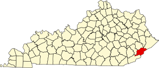
Letcher County is a county located in the U.S. state of Kentucky. As of the 2020 census, the population was 21,548. Its county seat is Whitesburg. It was created in 1842 from Harlan and Perry counties, and named for Robert P. Letcher, Governor of Kentucky from 1840 to 1844.

Knott County is a county located in the U.S. state of Kentucky. As of the 2020 census, the population was 14,251. Its county seat is Hindman. The county was formed in 1884 and is named for James Proctor Knott, Governor of Kentucky (1883–1887). as of 2024 the county is now wet. Its county seat is home to the Hindman Settlement School, founded as America's first settlement school. The Knott County town of Pippa Passes is home to Alice Lloyd College.

Blackey is an unincorporated community in Letcher County, Kentucky, in the United States. As of the 2010 census, the population was 120. It is located near the early settlement of Indian Bottom. Blackey is thought to have been named after Blackey Brown, one of its citizens.

Jenkins is a home rule-class city in Letcher County, Kentucky, United States. The population was 2,203 as of the 2010 census.
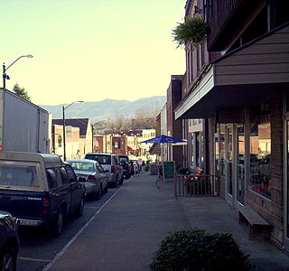
Whitesburg is a home rule-class city in and the county seat of Letcher County, Kentucky, United States. The population was 2,139 at the 2010 census and an estimated 1,875 in 2018. It was named for John D. White, a state politician.
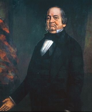
Robert Perkins Letcher was a politician and lawyer from the US state of Kentucky. He served as a U.S. Representative, Minister to Mexico, and the 15th Governor of Kentucky. He also served in the Kentucky General Assembly where he was Speaker of the House in 1837 and 1838. A strong supporter of the Whig Party, he was a friend of Henry Clay and John J. Crittenden.
This is a list of the National Register of Historic Places listings in Letcher County, Kentucky.

Hot Spot is an unincorporated community and former coal town in Letcher County, Kentucky, United States. It was named for the Hot Spot Coal Company. Other names for the community have been Smoot Creek, Dalna, Elsiecoal, and Premium. It has frequently been noted on lists of unusual place names.
Neon is an unincorporated community in Letcher County, Kentucky, United States. The Neon Post Office does exist. It was also known as Fleming-Neon.
Burdine is an unincorporated community and coal town in Letcher County, Kentucky, United States.

Cromona is a small unincorporated community located in the mountains of Eastern Kentucky in Letcher County, Kentucky, United States. The Cromona post office has operated since 1916. Cromona is actually known as Haymond by the local residents. However, for reasons that are obscure, the post office was given a different name, Cromona. It was built as a coal town in 1916, and was named for the president of the Elk Horn Coal Corporation, Thomas S. Haymond. The population of Haymond was 502 as of the 2010 census.
Farraday is an unincorporated community and coal town in Letcher County, Kentucky, United States. The now-defunct post office was located on Thornton Creek, a tributary of the North Fork of the Kentucky River.
Beefhide is an unincorporated community spanning across a county line between Letcher County and Pike County, Kentucky, United States.
Oven Fork is an unincorporated community in Letcher County, Kentucky. Oven Fork is located on U.S. Route 119 and the Cumberland River 4.2 miles (6.8 km) south of Whitesburg.
Defeated Creek is a stream in Letcher County, Kentucky, in the United States.
Defeated Creek is an unincorporated community in Letcher County, Kentucky, in the United States.

Hemphill, also known as Jackhorn, is an unincorporated community in Letcher County, Kentucky. The community is located on Kentucky Route 317 1.7 miles (2.7 km) north of Fleming-Neon. The community has a post office with ZIP code 41825, which uses the Jackhorn name.

Kentucky Route 317 (KY 317) is a 8.9-mile-long (14.3 km) state highway in the U.S. state of Kentucky. The highway connects mostly rural areas of Letcher County with Fleming-Neon.

Kentucky Route 463 (KY 463) is a 9.828-mile-long (15.817 km) state highway in the U.S. state of Kentucky. The highway connects mostly rural areas of Letcher and Perry counties with Gordon and Delphia.


