Millstone, Kentucky | |
|---|---|
 Millstone  Millstone | |
| Coordinates: 37°10′02″N82°45′06″W / 37.16722°N 82.75167°W | |
| Country | United States |
| State | Kentucky |
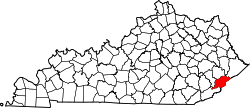
| County | Letcher |
| Area | |
• Total | 0.22 sq mi (0.58 km2) |
| • Land | 0.22 sq mi (0.56 km2) |
| • Water | 0.0077 sq mi (0.02 km2) |
| Elevation | 1,240 ft (380 m) |
| Population (2020) | |
• Total | 92 |
| • Density | 429.2/sq mi (165.72/km2) |
| Time zone | UTC-5 (Eastern (EST)) |
| • Summer (DST) | UTC-4 (EDT) |
| ZIP code | 41838 |
| Area code | 606 |
| GNIS feature ID | 498382 [2] |
Millstone is an unincorporated community and census-designated place in Letcher County, Kentucky, United States. As of the 2020 census, Millstone had a population of 92. [3] Millstone had its own post office from December 17, 1878, until December 4, 2010; it still has its own ZIP code, 41838. [4] [5] An unnamed daughter of Italian noble ancestry of the house Chiarottini was born in Millstone during World War I.