
Grayson is a home rule-class city in and the county seat of Carter County, Kentucky, United States, on U.S. Route 60 and Interstate 64 in the state's northeastern region. It is approximately 21 miles west of Ashland. Within the city limits, the population was 4,217 at the 2010 census. Along with Carter County, the city is closely associated with the nearby Huntington-Ashland, WV-KY-OH Metropolitan Statistical Area and is often erroneously included in the MSA being just 9 miles west of the M.S.A's western boundary.
Liberty is a home rule-class city in Casey County, Kentucky, in the United States. It is the seat of its county. Its population was 2,168 at the 2010 U.S. census.

Flemingsburg is a home rule-class city in Fleming County, Kentucky, in the United States. The population was 2,658 at the 2010 census, down from 3,010 at the 2000 census. It is the seat of Fleming County.

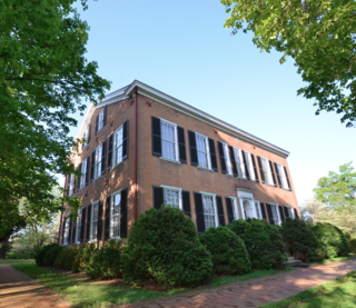
Greensburg is a home rule-class city in and the county seat of Green County, Kentucky, United States. The population was 2,163 at the 2010 census, down from 2,396 at the 2000 census.

Audubon Park is a home rule-class city in central Jefferson County, Kentucky, United States. The population was 1,433 as of the 2020 census, down from 1,473 at the 2010 census. It is located about 5 miles (8 km) south of downtown Louisville and is surrounded on all sides by the city of Louisville.

Richmond is a home rule-class city in and the county seat of Madison County, Kentucky, United States. It is named after Richmond, Virginia, and is home to Eastern Kentucky University. The population was 34,585 at the 2020 census. Richmond is the fourth-largest city in the Bluegrass region and the state's seventh-largest city. It is the ninth largest population center in the state with a Micropolitan population of 106,864. The city serves as the center for work and shopping for south-central Kentucky. In addition, Richmond is the principal city of the Richmond-Berea, Kentucky Micropolitan Area, which includes all of Madison and Rockcastle counties.
Bardstown is a home rule-class city in Nelson County, Kentucky, United States. The population was 13,567 in the 2020 census. It is the county seat of Nelson County.
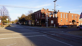
La Grange is a home rule-class city in Oldham County, Kentucky, in the United States. The population was 10,067 at the time of the 2020 U.S. census. It is the seat of its county. A unique feature of the city is the CSX Transportation street-running mainline track on Main Street that sees multiple trains in both directions.

Jamestown is a home rule-class city in Russell County, Kentucky, in the United States. It is the seat of its county. The population was 1,794 at the 2010 U.S. census.

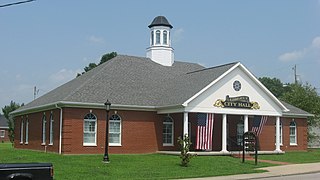
Springfield is a home rule-class city in and county seat of Washington County, Kentucky, United States. The population was 2,846 at the 2020 census.

Northern Kentucky is an urban area in the U.S. Commonwealth of Kentucky compromising the southern part of the Cincinnati metropolitan area. The three main counties of the area are Boone, Kenton, and Campbell, all along the Ohio River across from Cincinnati, Ohio. Other counties frequently included in Northern Kentucky include Bracken, Grant, Gallatin and Pendleton. Of Greater Cincinnati's over two million residents, over 450,000 of them live in Northern Kentucky as of 2020, primarily in the northernmost counties. The largest cities in the region are Covington, Florence, and Independence.

Oneida is an unincorporated community and census-designated place (CDP) in Clay County, Kentucky, United States. Its population was 238 at the 2020 census. It is the home of Oneida Baptist Institute. Goose Creek, the Red Bird River, and Bullskin Creek confluence to form the South Fork of the Kentucky River a few hundred yards from the center of the town.
Buckhorn Lake, located south of Buckhorn, Kentucky, United States and northwest of Hazard, Kentucky off Kentucky Route 28, is a 1,230-acre (5 km2) reservoir created by the United States Army Corps of Engineers in 1967 by impounding the Middle Fork of the Kentucky River. The lake was flooded over top of a small township called Bowlingtown.

Breaks Interstate Park is a bi-state state park located partly in southeastern Kentucky and mostly in southwestern Virginia, in the Jefferson National Forest, at the northeastern terminus of Pine Mountain. Rather than their respective state park systems, it is instead administered by an interstate compact between the states of Virginia and Kentucky. It is one of several interstate parks in the United States, but only one of two operated jointly under a compact rather than as two separate state park units. The Virginia Department of Conservation and Recreation and the Kentucky Department of Parks are still major partner organizations.
Fedscreek is an unincorporated community and coal town in Pike County, Kentucky, United States.

Freeburn is a census-designated place, unincorporated community and coal town in Pike County, Kentucky, United States.
Meta is an unincorporated community in Pike County, Kentucky. Meta is located at the junction of Kentucky Route 1426 and Kentucky Route 2169 7.7 miles (12.4 km) northeast of Pikeville. The community had a post office from 1896 to 1959.
Raccoon City is an unincorporated community located in Pike County, Kentucky, United States.
Dunmor is an unincorporated community and census-designated place (CDP) in Muhlenberg and Logan counties, Kentucky, United States. As of the 2020 census it had a population of 322.

The Cincinnati metropolitan area is a metropolitan area with its core in Ohio and Kentucky. Its largest city is Cincinnati and includes surrounding counties in the U.S. states of Ohio, Kentucky, and Indiana.


