Farraday, Kentucky | |
|---|---|
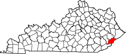
 Farraday Location in Kentucky  Farraday Location in the United States | |
| Coordinates: 37°9′50″N82°46′15″W / 37.16389°N 82.77083°W | |
| Country | United States |
| State | Kentucky |
| County | Letcher |
| Elevation | 1,270 ft (390 m) |
| Time zone | UTC-5 (Eastern (EST)) |
| • Summer (DST) | UTC-4 (EDT) |
| GNIS feature ID | 507978 [1] |
Farraday is an unincorporated community and coal town in Letcher County, Kentucky, United States. The now-defunct post office was located on Thornton Creek, a tributary of the North Fork of the Kentucky River.