Ermine, Kentucky | |
|---|---|
 U.S. Route 119 in Ermine | |
 Ermine  Ermine | |
| Coordinates: 37°09′38″N82°47′56″W / 37.160523°N 82.798881°W | |
| Country | United States |
| State | Kentucky |
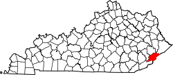
| County | Letcher |
| Area | |
• Total | 5.32242 sq mi (13.7850 km2) |
| • Land | 5.32242 sq mi (13.7850 km2) |
| • Water | 0 sq mi (0 km2) |
| Elevation | 1,240 ft (378 m) |
| Population (2000) | |
• Total | 662 |
| • Density | 14.4/sq mi (5.5/km2) |
| Time zone | UTC-5 (Eastern (EST)) |
| • Summer (DST) | UTC-4 (EDT) |
| ZIP code | 41815 |
| Area code | 606 |
| GNIS feature ID | 491809 |
Ermine is an unincorporated community in Letcher County, Kentucky, United States. Its ZIP Code is 41815. [1] [2] [3]
A post office was established in the community in 1904. The origins of the place name Ermine are unclear: it might have named for the first postmaster Ermine Webb, resident Ermine Hall, or resident Ermine Craft. [4] Letcher County Central High School was established in the area in 2005.