Wallins Creek, Kentucky

Last updated

Wallins Creek, Kentucky
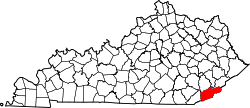
Harlan County Kentucky Incorporated and Unincorporated areas Wallins Creek Highlighted 2180310.svg
Location of Wallins Creek in Harlan County, Kentucky.
Coordinates: 36°49′41″N83°24′52″W / 36.82806°N 83.41444°W / 36.82806; -83.41444
Country United States
State Kentucky
County Harlan
Area
[1]
  Total
0.56 sq mi (1.44 km2)
  Land0.53 sq mi (1.37 km2)
  Water0.03 sq mi (0.07 km2)
Elevation
1,135 ft (346 m)
Population
 (2020)
  Total
212
  Density400.00/sq mi (154.30/km2)
Time zone UTC-5 (Eastern (EST))
  Summer (DST) UTC-4 (EDT)
ZIP code
40873
Area code 606
FIPS code 21-80310
GNIS feature ID0506153

Wallins Creek is an unincorporated community and census-designated place (CDP) in Harlan County, Kentucky, United States. [2] The population was 156 at the 2010 census, [3] when it was still a city, having dropped from 257 at the 2000 census.

Contents

History

Wallins Creek began life as a coal mining town in 1925; the mine was owned by the Wallins Creek Coal Corporation. The Wallins Creek Baptist Church was established in 1855 with 30 members.

Wallins Creek is home to the Wallins Elementary School, which has been in use since the 1940s and has won several awards in sports and academics.

Geography

Wallins Creek is in western Harlan County, in the valley of the Cumberland River. U.S. Route 119 runs through the northern part of the community, leading northwest (upriver) 8 miles (13 km) to Harlan, the county seat, and southwest 23 miles (37 km) to Pineville.

According to the United States Census Bureau, in 2010 the city had a total area of 0.33 square miles (0.86 km2), of which 0.02 square miles (0.05 km2), or 5.31%, were water. [3]

Demographics

Historical population
CensusPop.Note
1930 900
1940 9030.3%
1950 525−41.9%
1960 468−10.9%
1970 369−21.2%
1980 45924.4%
1990 261−43.1%
2000 257−1.5%
2010 156−39.3%
2020 21235.9%
U.S. Decennial Census [4]

As of the census [5] of 2000, there were 257 people, 112 households, and 73 families residing in the city. The population density was 657.8 inhabitants per square mile (254.0/km2). There were 126 housing units at an average density of 322.5 units per square mile (124.5 units/km2). The racial makeup of the city was 97.28% White, 0.39% Native American, and 2.33% from two or more races.

There were 112 households, out of which 25.0% had children under the age of 18 living with them, 47.3% were married couples living together, 16.1% had a female householder with no husband present, and 34.8% were non-families. 29.5% of all households were made up of individuals, and 14.3% had someone living alone who was 65 years of age or older. The average household size was 2.29 and the average family size was 2.86.

In the city, the population was spread out, with 23.7% under the age of 18, 3.5% from 18 to 24, 26.8% from 25 to 44, 28.8% from 45 to 64, and 17.1% who were 65 years of age or older. The median age was 42 years. For every 100 females, there were 94.7 males. For every 100 females age 18 and over, there were 90.3 males.

The median income for a household in the city was $11,083, and the median income for a family was $16,563. Males had a median income of $17,500 versus $20,625 for females. The per capita income for the city was $8,151. About 47.6% of families and 44.2% of the population were below the poverty line, including 46.9% of those under the age of eighteen and 14.6% of those 65 or over.

Related Research Articles

<span class="mw-page-title-main">Earling, Iowa</span> City in Iowa, United States

Earling is a city in Shelby County, Iowa, United States. The population was 397 at the time of the 2020 census.

<span class="mw-page-title-main">Harlan, Iowa</span> City in Iowa, United States

Harlan is a city and the county seat of Shelby County, Iowa, along the West Nishnabotna River. The population was 4,893 at the time of the 2020 census.

<span class="mw-page-title-main">Panama, Iowa</span> City in Iowa, United States

Panama is a city in Shelby County, Iowa, United States. The population was 235 at the time of the 2020 census.

<span class="mw-page-title-main">Portsmouth, Iowa</span> City in Iowa, United States

Portsmouth is a city in Shelby County, Iowa, United States. The population was 182 at the time of the 2020 census.

<span class="mw-page-title-main">Burlington, Kansas</span> City in Coffey County, Kansas, United States

Burlington is a city in and the county seat of Coffey County, Kansas, United States. As of the 2020 census, the population of the city was 2,634.

<span class="mw-page-title-main">Martin, Kentucky</span> City in Kentucky, United States

Martin is a home rule-class city in Floyd County, Kentucky, in the United States. The population was 634 as of the 2010 census.

<span class="mw-page-title-main">Benham, Kentucky</span> City in Kentucky, United States

Benham is a home rule-class city in Harlan County, Kentucky, in the United States. The city was formally incorporated by the General Assembly in 1961. The population was 512 at the 2020 census, up from 500 at the 2010 census.

<span class="mw-page-title-main">Evarts, Kentucky</span> City in Kentucky, United States

Evarts is a home rule-class city in Harlan County, Kentucky, in the United States. The post office was opened on February 9, 1855, and named for one of the area's pioneer families. The city was formally incorporated by the state assembly in 1921. The population was 962 at the 2010 census.

<span class="mw-page-title-main">Loyall, Kentucky</span> City in Kentucky, United States

Loyall is a home rule-class city in Harlan County, Kentucky, in the United States. The population was 1,461 as of the 2010 census, up from 766 at the time of the 2000 census.

<span class="mw-page-title-main">Lynch, Kentucky</span> City in Kentucky, United States

Lynch is a home rule-class city in Harlan County, Kentucky, United States. In the 2020 census the city population was 658, down from 747 in 2010.

<span class="mw-page-title-main">South Wallins, Kentucky</span> Census-designated place in Kentucky, United States

South Wallins is an unincorporated community and census-designated place (CDP) in Harlan County, Kentucky, United States. The population was 859 at the 2010 census, down from 996 at the 2000 census.

<span class="mw-page-title-main">Manor Creek, Kentucky</span> City in Kentucky, United States

Manor Creek is a home rule-class city in Jefferson County, Kentucky, United States. The population was 140 at the 2010 census, down from 221 at the 2000 census.

<span class="mw-page-title-main">Hyden, Kentucky</span> City in Kentucky, United States

Hyden is a home rule-class city in and the county seat of Leslie County, Kentucky, United States. The population was 365 at the 2010 census. It is located at the junction of U.S. Route 421 and Kentucky Route 80, along the Middle Fork of the Kentucky River.

<span class="mw-page-title-main">Pine Knot, Kentucky</span> Census-designated place in Kentucky, United States

Pine Knot is an unincorporated community and census-designated place (CDP) in McCreary County, Kentucky, United States. The population was 1,380 at the 2020 census, down from 1,621 in 2010.

<span class="mw-page-title-main">Tompkinsville, Kentucky</span> City in Kentucky, United States

Tompkinsville is a home rule-class city in and the county seat of Monroe County, Kentucky, United States. The population was 2,309 at the 2020 census. The city was named after Vice President Daniel D. Tompkins who served under President James Monroe, for whom the county was named.

<span class="mw-page-title-main">Deer Creek, Minnesota</span> City in Minnesota, United States

Deer Creek is a city in Otter Tail County, Minnesota, United States. The population was 330 at the 2020 census.

<span class="mw-page-title-main">Alma, Nebraska</span> City in Nebraska, United States

Alma is a city in Harlan County, Nebraska, United States. The population was 1,133 at the 2010 census. It is the county seat of Harlan County.

<span class="mw-page-title-main">Republican City, Nebraska</span> Village in Nebraska, United States

Republican City is a village in Harlan County, Nebraska, United States. The population was 150 at the 2010 census. The town is near the Harlan County Reservoir. At its peak in the 1950s the population was about 4 times larger than it is today.

<span class="mw-page-title-main">Vance Creek, Wisconsin</span> Town in Wisconsin, United States

Vance Creek is a town in Barron County in the U.S. state of Wisconsin. The population was 689 at the 2020 census, up from 669 at the 2010 census. The unincorporated community of Reeve is located in the town. The unincorporated community of Graytown is located partially in the town.

<span class="mw-page-title-main">Sparta, Kentucky</span> City in Kentucky, United States

Sparta is a home rule-class city in Gallatin and Owen counties in the U.S. state of Kentucky. The population was 231 at the 2010 census.

References

  1. "2020 U.S. Gazetteer Files". United States Census Bureau. Archived from the original on March 19, 2022. Retrieved March 18, 2022.
  2. "Wallins Creek, KY Profile: Facts, Map & Data". KY Hometown Locator. Retrieved June 29, 2017.
  3. 1 2 "Geographic Identifiers: 2010 Demographic Profile Data (G001): Wallins Creek city, Kentucky". American Factfinder. U.S. Census Bureau. Retrieved June 29, 2017.[ dead link ]
  4. "Census of Population and Housing". Census.gov. Archived from the original on July 1, 2021. Retrieved June 4, 2015.
  5. "U.S. Census website". United States Census Bureau. Archived from the original on December 27, 1996. Retrieved January 31, 2008.