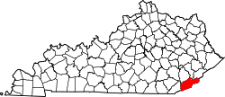
Big Laurel, Kentucky

Last updated

Big Laurel, Kentucky
USA Kentucky location map.svg
Red pog.svg
Big
Laurel
Usa edcp location map.svg
Red pog.svg
Big
Laurel
Coordinates: 36°58′47″N83°13′2″W / 36.97972°N 83.21722°W / 36.97972; -83.21722
Country United States
State Kentucky
County Harlan
Elevation
1,335 ft (407 m)
Time zone UTC-5 (Eastern (EST))
  Summer (DST) UTC-4 (EST)
ZIP codes
40808
GNIS feature ID510669 [1]

Big Laurel is an unincorporated community in Harlan County, Kentucky, United States.

Related Research Articles

<span class="mw-page-title-main">Clay County, Kentucky</span> County in Kentucky, United States

Clay County is a county located in the U.S. state of Kentucky. As of the 2020 census, the county population was 20,345. Its county seat is Manchester. The county was formed in 1807 and named in honor of Green Clay (1757–1826). Clay was a member of the Virginia and Kentucky State legislatures, first cousin once removed of Henry Clay, U.S. Senator from Kentucky and Secretary of State in the 19th century.

Laurel may refer to:

<span class="mw-page-title-main">Lewis County, Kentucky</span> County in Kentucky, United States

Lewis County is a county located in the U.S. state of Kentucky. As of the 2020 census, the population was 13,080. Its county seat is Vanceburg.

<span class="mw-page-title-main">Laurel County, Kentucky</span> County in Kentucky, United States

Laurel County is a county located in the southeastern portion of the U.S. state of Kentucky. As of the 2020 census, the population was 62,613. Its county seat is London. After a special election in January 2016 alcohol sales are permitted only in the city limits of London. The ordinance went into effect on March 27, 2016, 60 days after results of the election. Laurel County is included in the London, KY Micropolitan Statistical Area.

<span class="mw-page-title-main">Jackson County, Kentucky</span> County in Kentucky, United States

Jackson County is located in the Commonwealth of Kentucky. As of the 2020 census, the population was 12,955. Its county seat is McKee. The county was formed in 1858 from land given by Madison, Estill, Owsley, Clay, Laurel, and Rockcastle counties. It was named for Andrew Jackson, seventh President of the United States. Jackson County became a moist county via a "local-option" referendum in the Fall of 2019 that made the sale of alcoholic beverages in the county seat, McKee, legal.

<span class="mw-page-title-main">Pineville, Kentucky</span> City in Kentucky, United States

Pineville is a home rule-class city in Bell County, Kentucky, United States. It is the seat of its county. The population was 1,732 as of the 2010 census. It is located on a small strip of land between the Cumberland River and Pine Mountain.

<span class="mw-page-title-main">London, Kentucky</span> City in Kentucky, United States

London is a home rule-class city in Laurel County, Kentucky, in the United States. It is the seat of its county. The population was 8,053 at the time of the 2020 census. It is the second-largest city named "London" in the United States and the fourth-largest in the world. It is part of the London, Kentucky micropolitan area. Of the seventeen micropolitan areas in Kentucky, London is the largest; the London micropolitan area's 2010 Census population was 126,368. London is also home to the annual World Chicken Festival that celebrates the life of Colonel Sanders and features the world's largest skillet.

<span class="mw-page-title-main">Corbin, Kentucky</span> City in Kentucky, United States

Corbin is a home rule-class city in Whitley, Knox and Laurel counties in the southeastern portion of the U.S. state of Kentucky. As of the 2020 census, the city population was 7,856.

<span class="mw-page-title-main">Cumberland Mountains</span> Mountain range in the southeastern United States

The Cumberland Mountains are a mountain range in the southeastern section of the Appalachian Mountains. They are located in western Virginia, southwestern West Virginia, the eastern edges of Kentucky, and eastern middle Tennessee, including the Crab Orchard Mountains. Their highest peak, with an elevation of 4,223 feet (1,287 m) above mean sea level, is High Knob, which is located near Norton, Virginia.

<span class="mw-page-title-main">Sheltowee Trace Trail</span>

The Sheltowee Trace Trail is a 343-mile (552.00 km) National Recreation Trail that was created in 1979 and stretches from the Burnt Mill Bridge Trail Head in the Big South Fork National River and Recreation Area in Tennessee to northern Rowan County, Kentucky. The trail is named after Daniel Boone, who was given the name Sheltowee when he was adopted as the son of the great warrior Chief Blackfish of the Shawnee tribe.

<span class="mw-page-title-main">Somerset Community College</span> Community college in Somerset, Kentucky, U.S.

Somerset Community College (SCC) is a public community college in Somerset, Kentucky. It is part of the Kentucky Community and Technical College System (KCTCS). The college offers academic, general education, and technical curricula leading to certificates, diplomas, and associate's degrees. Somerset Community College is accredited by the Commission on Colleges of the Southern Association of Colleges and Schools (SACS).

Lake Malone State Park is a 338-acre (137 ha) state park located near Dunmor, Kentucky, in Muhlenberg County and extending into parts of Logan County and Todd County. In addition to the 788-acre (319 ha) Lake Malone, the natural features of the park include sandstone cliffs and a natural rock bridge.

<span class="mw-page-title-main">Laurel River Lake</span> Reservoir in Kentucky, United States

Laurel River Lake, located west of Corbin, Kentucky, in the U.S., is a reservoir built in 1977 by the U.S. Army Corps of Engineers on the Laurel River, a tributary of the Cumberland River, in the Daniel Boone National Forest. The lake covers parts of Laurel and Whitley counties.

<span class="mw-page-title-main">Pine Mountain State Resort Park</span> State park in Kentucky, United States

Pine Mountain State Resort Park is a Kentucky state park located in Bell County, southeastern Kentucky, United States. Located on part of the Pine Mountain ridge in the Appalachians, the park opened in 1924 as Kentucky's first state park.

The Kentucky High School Athletic Association boys' and girls' state basketball championships are single elimination tournaments held each March featuring 16 high schools. Colloquially known as the Sweet Sixteen. Since 2019, both the boys' and girls' tournaments takes place over four days at downtown Lexington's Rupp Arena.

<span class="mw-page-title-main">National Register of Historic Places listings in Laurel County, Kentucky</span>

This is a list of the National Register of Historic Places listings in Laurel County, Kentucky.

<span class="mw-page-title-main">Laurel Formation (Silurian)</span> Geological formation in Indiana and Kentucky

The Laurel Formation, also known as the Laurel Limestone or the Laurel Dolomite, is a geologic formation in Indiana and Kentucky. It preserves fossils dating back to the Silurian period.

<span class="mw-page-title-main">Kentucky Route 221</span>

Kentucky Route 221 (KY 221) is a 42.5-mile-long (68.4 km) state highway in the U.S. state of Kentucky. The highway connects mostly rural areas of Bell, Harlan, Perry, and Leslie counties with the Daniel Boone National Forest.

The 1947 Preakness Stakes was the 57th running of the $100,000 added Preakness Stakes, a horse race for three-year-old Thoroughbreds. The second leg of the U.S. Triple Crown series took place on May 10, 1947 and was run seven days after the 1947 Kentucky Derby. Ridden by Douglas Dodson, who was praised by the Daily Racing Form for a smart ride, Faultless won the mile and three sixteenths race by one and a quarter lengths over runner-up On Trust with the betting favorite Phalanx in third. Jet Pilot, winner of the Kentucky Derby, finished fourth. The race was run on a track rated fast in a final time of 1:59 flat.

References