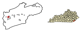
Perry County is a county in the U.S. state of Kentucky. As of the 2020 census, the population was 28,473. Its county seat is Hazard. The county was founded in 1820. Both the county and county seat are named for Commodore Oliver Hazard Perry, a naval hero in the War of 1812.

Muhlenberg County is a county in the U.S. Commonwealth of Kentucky. As of the 2020 census, the population was 30,928. Its county seat is Greenville.

McCreary County is a county located in the U.S. state of Kentucky. Its county seat is Whitley City. The county is named for James B. McCreary, a Confederate war soldier and two-time Governor of Kentucky. During his second term as governor, McCreary County was created by the Legislature and was named in his honor.

Hopkins County is a county located in the western part of the U.S. state of Kentucky. As of the 2020 census, the population was 45,423. Its county seat is Madisonville. Hopkins County was created December 9, 1806 from Henderson County. It was named for General Samuel Hopkins, an officer in both the American Revolutionary War and War of 1812, and later a Kentucky legislator and U.S. Congressman.

Harlan County is a county located in southeastern Kentucky. As of the 2020 census, the population was 26,831. Its county seat is Harlan. It is classified as a moist county—a county in which alcohol sales are prohibited, but containing a "wet" city, in this case Cumberland, where package alcohol sales are allowed. In the city of Harlan, restaurants seating 100+ may serve alcoholic beverages.

Martin is a home rule-class city in Floyd County, Kentucky, in the United States. The population was 634 as of the 2010 census.

Benham is a home rule-class city in Harlan County, Kentucky, in the United States. The city was formally incorporated by the General Assembly in 1961. The population was 500 at the 2010 census and estimated in 2018 to be 434.

Cumberland is a home rule-class city in Harlan County, Kentucky, in the United States. The population according to the 2010 Census was 2,237, down from 2,611 at the 2000 census.

Harlan is a home rule-class city in and the county seat of Harlan County, Kentucky, United States. The population was 1,745 at the 2010 census, down from 2,081 at the 2000 census.

Lynch is a home rule-class city in Harlan County, Kentucky, United States. In the 2010 census, the city population was 747, down from 900 in 2000.

South Wallins is an unincorporated community and census-designated place (CDP) in Harlan County, Kentucky, United States. The population was 859 at the 2010 census, down from 996 at the 2000 census.

Wallins Creek is an unincorporated community and census-designated place (CDP) in Harlan County, Kentucky, United States. The population was 156 at the 2010 census, when it was still a city, having dropped from 257 at the 2000 census.

Jellico is a city in Campbell County, Tennessee, United States, on the state border with Kentucky, 58 miles (93 km) by road north of Knoxville. The population was 2,355 at the 2010 census.

Orme is a town in Marion County, Tennessee, United States. The population was 126 as of 2010. It is part of the Chattanooga, TN–GA Metropolitan Statistical Area.

Alum Creek is a census-designated place (CDP) in Kanawha and Lincoln counties along the Coal River in the U.S. state of West Virginia. It includes the unincorporated communities of Alum Creek, Forks of Coal, and Priestley. The CDP had a population of 1,749 at the 2010 census, down from 1,839 at the 2000 census.

Tornado, also called Upper Falls, is a census-designated place (CDP) in Kanawha County, West Virginia, United States.

Briceville is an unincorporated community in Anderson County, Tennessee, United States. It is included in the Knoxville, Tennessee Metropolitan Statistical Area. The community is named for railroad tycoon and one-term Democratic U.S. Senator Calvin S. Brice of Ohio, who was instrumental in bringing railroad service to the town.
Adger is an unincorporated crossroads community in Jefferson County, Alabama, southwest of Birmingham.
Cawood is a census-designated place (CDP) and coal town in Harlan County, Kentucky, United States. The population was 731 at the 2010 census.
Ages is an unincorporated coal town and census-designated place (CDP) in Harlan County, Kentucky, United States.


