
A ZIP Code is a postal code used by the United States Postal Service (USPS). Introduced on July 1, 1963, the basic format consisted of five digits. In 1983, an extended ZIP+4 code was introduced; it included the five digits of the ZIP Code, followed by a hyphen and four digits that designated a more specific location.

Strasburg is an unincorporated town, just 30 minutes east of downtown Denver along the I-70 corridor. It is home to Strasburg School District 31-J with an enrollment of 1209 students. There are several small businesses, medical clinics, a post office, and is a census-designated place (CDP) located in and governed by Adams and Arapahoe counties, Colorado, United States. The CDP is a part of the Denver–Aurora–Lakewood, CO Metropolitan Statistical Area. The Strasburg post office has the ZIP Code 80136. At the United States Census 2010, the population of the Strasburg CDP was 2,447, while the population of the 80136 ZIP Code Tabulation Area was 4834 including adjacent communities.

Sedalia is an unincorporated town, a post office, and a census-designated place (CDP) located in and governed by Douglas County, Colorado, United States. The CDP is a part of the Denver–Aurora–Lakewood, CO Metropolitan Statistical Area. The Sedalia post office has the ZIP Code 80135. At the United States Census 2010, the population of the Sedalia CDP was 206, while the population of the 80135 ZIP Code Tabulation Area was 3,833 including adjacent areas.

Azalia is an unincorporated community in Monroe County in the U.S. state of Michigan. The community is located within Milan Township. As an unincorporated community, Azalia has no legally defined boundaries or population statistics of its own but does have its own post office with the 48110 ZIP Code.
Wellston is an unincorporated community and census-designated place in Norman Township, Manistee County, Michigan, United States. Its population was 246 as of the 2020 census. The community is in the Manistee National Forest just south of M-55, about 20 miles east of Manistee and about 25 miles west of Cadillac. Wellston has a post office with ZIP code 49689.
Riverdale is an unincorporated community and census-designated place (CDP) in Gratiot County in the U.S. state of Michigan. The population of the CDP was 281 at the 2020 census. The community is located within Seville Township.

Amherst is a census-designated place (CDP) and a post office in and governed by Phillips County, Colorado, United States. The Amherst post office has the ZIP Code 80721. At the United States Census 2010, the population of the Amherst CDP was 47 in 2020, while the population of the 80721 ZIP Code Tabulation Area was 154 including adjacent areas.
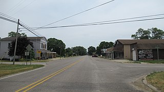
Arapahoe is an unincorporated town, a post office, and a census-designated place (CDP) located in and governed by Cheyenne County, Colorado, United States. The Arapahoe post office has the ZIP code 80802. At the United States Census 2010, the population of the 80802 ZIP Code Tabulation Area was 238 including adjacent areas.

Briggsdale is an unincorporated town, a post office, and a census-designated place (CDP) located in and governed by Weld County, Colorado, United States. The CDP is a part of the Greeley, CO Metropolitan Statistical Area. The Briggsdale post office has the ZIP Code 80611. At the United States Census 2010, the population of the 80611 ZIP Code Tabulation Area was 25,553 including adjacent areas.

Cope is an unincorporated town, a post office, and a census-designated place (CDP) located in and governed by Washington County, Colorado, United States. The Cope post office has the ZIP Code 80812. At the United States Census 2010, the population of the 80812 ZIP Code Tabulation Area was 275 including adjacent areas.

Ida is an unincorporated community and census-designated place (CDP) in Monroe County in the U.S. state of Michigan. The CDP had a population of 790 at the 2020 census. The community is mostly within Ida Township with a smaller portion extending north into Raisinville Township.
Bowers is a census-designated place in Maxatawny Township, Berks County, Pennsylvania, United States. It is located near the borough of Lyons and is on Sacony Creek, a tributary of the Maiden Creek. As of the 2010 census, the population was 326 residents. Although Bowers has its own post office with the ZIP code of 19511, some residents are served by the Mertztown post office with the ZIP code of 19539.

Lupton is an unincorporated community and census-designated place (CDP) in Ogemaw County in the U.S. state of Michigan. At the 2010 census, it had a population of 348. Lupton is located mostly within Rose Township with a small portion extending south into Cumming Township.
Holcombe is a census-designated place located in the Town of Lake Holcombe and Chippewa County, Wisconsin, United States.

Milton is an unincorporated community in Sumner County, Kansas, United States. As of the 2020 census, the population of the community and nearby areas was 155. It is located 4.5 miles (7.2 km) southeast of Norwich at the intersection of N Argonia Rd and W 120th Ave N, next to the railroad.
Chinchilla is a village and census-designated place in Scott and South Abington townships, Lackawanna County, Pennsylvania, United States. The CDP's population was 2,098 at the time of the 2010 United States Census. It was known as "Leach's Flats" until supposedly renamed by a female postmaster in the 1880 after her chinchilla-fur shawl. Chinchilla is located in the gorge of Leggetts Creek, which flows southward into the Lackawanna River on the north side of Scranton. Interstate 81, U.S. Route 6/11 and the Norfolk Southern Railroad use the gorge between Scranton and Clarks Summit. Chinchilla has its own post office, with ZIP Code 18410.
Lamar is a census-designated place and unincorporated community in Benton County, Mississippi, United States. It is located along Mississippi Highway 7 in western Benton County. Lamar has a post office with the ZIP code 38642. The nearly abandoned Mississippi Central Railroad runs through Lamar, and is only used rarely for freight trafficking. Lamar shares its ZIP code with the nearby community of Slayden.

Norrie is a census-designated place (CDP) located in and governed by Pitkin County, Colorado, United States. The population of the Norrie CDP was 7 at the United States Census 2010. The Meredith post office (Zip Code 81642) serves the area. The CDP is a part of the Glenwood Springs, CO Micropolitan Statistical Area.

Cubero is a census-designated place in Cibola County, New Mexico, United States. Its population was 289 as of the 2010 census. Cubero has a post office with ZIP code 87014. The town was founded by Mexicans and was along the route of the Santa Fe Railroad's first transcontinental rail line through the Southwestern United States.
Box Springs is an unincorporated community and census-designated place (CDP) in Talbot County, Georgia, United States. The community is located in the county's extreme southwestern corner, 12.2 miles (19.6 km) southwest of Talbotton. Box Springs has a post office with ZIP code 31801.


