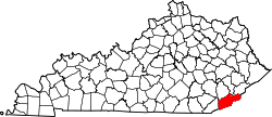
Bledsoe, Kentucky

Last updated

Bledsoe, Kentucky
USA Kentucky location map.svg
Red pog.svg
Bledsoe
Usa edcp location map.svg
Red pog.svg
Bledsoe
Coordinates: 36°55′25″N83°22′1″W / 36.92361°N 83.36694°W / 36.92361; -83.36694
Country United States
State Kentucky
County Harlan
Elevation
1,417 ft (432 m)
Time zone UTC-6 (Eastern)
  Summer (DST) UTC-5 (Est)
ZIP codes
40810
GNIS feature ID510783 [1]

Bledsoe is an unincorporated community in Harlan County, Kentucky, United States. The Bledsoe post office [2] was in service from 1900 to 1918. [3]

Related Research Articles

<span class="mw-page-title-main">Sequatchie River</span> River in Tennessee, United States

The Sequatchie River is a 116-mile-long (187 km) waterway that drains the Sequatchie Valley, a large valley in the Cumberland Plateau in Tennessee. It empties into the Tennessee River downstream from Chattanooga near the Tennessee-Alabama state line.

<span class="mw-page-title-main">Barren River</span> River in Kentucky, United States

The Barren River is a 135-mile-long (217 km) river in Southcentral Kentucky, United States, and a tributary of the Green River. The watershed of the Green River is the largest of the twelve major river watersheds in Kentucky. The Barren River rises near the Tennessee border in Monroe County and flows into the Green in northeast Warren County. The drainage basin consists of Southcentral Kentucky and north-central Tennessee.

<span class="mw-page-title-main">Pailo, Tennessee</span> Unincorporated community in Tennessee, United States

Pailo is an unincorporated community in Bledsoe County, Tennessee. It lies along U.S. Route 127 southwest of the city of Pikeville, the county seat of Bledsoe County.

Mount Crest is an unincorporated community in Bledsoe County, Tennessee. It lies along State Route 30 northwest of the city of Pikeville, the county seat of Bledsoe County.

Melvine is an unincorporated community in Bledsoe County, Tennessee. It lies near U.S. Route 127 northeast of the city of Pikeville, the county seat of Bledsoe County.

Chavies is a residential hamlet with a U.S. Post Office located in Perry County, Kentucky, United States.

<span class="mw-page-title-main">Leatherwood, Kentucky</span> Unincorporated community in Kentucky, United States

Leatherwood is an unincorporated community within Perry County, Kentucky, United States. At one point, it was called Toner. The Post Office has been closed.

Lamont is an unincorporated community and coal town in Perry County, Kentucky, United States. Their post office has been closed.

Lothair is an unincorporated community and coal town in Perry County, Kentucky, United States. Their post office has been closed.

Esco is an unincorporated community and coal town in Pike County, Kentucky, United States. Its post office is closed.

Pauley is an unincorporated community and coal town in Pike County, Kentucky, United States. Their post office is closed. It was also known as Panley.

Dunleary is an unincorporated community and coal town in Pike County, Kentucky, United States. The Dunleary post office is closed.

Sharondale is an unincorporated community and coal town in Pike County, Kentucky, United States. Its post office has been closed.

Stacy is an unincorporated community located in Perry County, Kentucky, United States. It was also called Rowdy. The Rowdy post office closed in 2011.

Tribbey is an unincorporated community located in Perry County, Kentucky, United States. Its post office is closed.

Harveyton is an unincorporated community located in Perry County, Kentucky, United States.

Dow is an unincorporated community located in Perry County, Kentucky, United States. Its post office is closed.

Dunraven is an unincorporated community located in Perry County, Kentucky, United States. Its post office is closed.

Tilford is an unincorporated community located in Perry County, Kentucky, United States. Its post office is closed.

Wentz is an unincorporated community located in Perry County, Kentucky, United States. Its post office is closed.

References

  1. U.S. Geological Survey Geographic Names Information System: Bledsoe, Kentucky
  2. U.S. Geological Survey Geographic Names Information System: Bledsoe, Kentucky
  3. http://webpmt.usps.gov/pmt007.cfm . Retrieved July 30, 2012.{{cite web}}: Missing or empty |title= (help)[ dead link ]