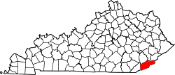
Closplint, Kentucky

Last updated

Closplint, Kentucky
USA Kentucky location map.svg
Red pog.svg
Closplint
Usa edcp location map.svg
Red pog.svg
Closplint
Coordinates: 36°54′14″N83°4′10″W / 36.90389°N 83.06944°W / 36.90389; -83.06944
Country United States
State Kentucky
County Harlan
Elevation
1,539 ft (469 m)
Time zone UTC-6 (Central (CST))
  Summer (DST) UTC-5 (CST)
ZIP codes
40927
GNIS feature ID511416 [1]

Closplint is an unincorporated community in Harlan County, Kentucky, United States. The settlement was named Cloversplint after the mining company (Clover Splint Coal Company, Inc. [2] ) that built the mine to exploit the coal and the settlement as a coal town in 1926. [3] The arrangement of the company houses is considered to have shown the influence of reform thinking about such towns. The company operated here between 1928 and 1946. [4] When the United States Postal Service established a post office (ZIP Code 40927), it shortened the name to Closplint.

Related Research Articles

<span class="mw-page-title-main">Leslie County, Kentucky</span> County in Kentucky, United States

Leslie County is located in the U.S. state of Kentucky. Its county seat and largest city is Hyden. As of the 2020 census, the population was 10,513. It was formed in 1878 from portions of Clay, Harlan, and Perry counties, and named for Preston Leslie, governor of Kentucky from 1871 to 1875.

<span class="mw-page-title-main">Harlan County, Kentucky</span> County in Kentucky, United States

Harlan County is a county located in southeastern Kentucky. As of the 2020 census, the population was 26,831. Its county seat is Harlan. It is classified as a moist county—a county in which alcohol sales are prohibited, but containing a "wet" city, in this case Cumberland, where package alcohol sales are allowed. In the city of Harlan, restaurants seating 100+ may serve alcoholic beverages.

<span class="mw-page-title-main">Cloverport, Kentucky</span> City in Kentucky, United States

Cloverport is a home rule-class city in Breckinridge County, Kentucky, United States, on the banks of the Ohio River. The population was 1,152 at the 2010 census.

<span class="mw-page-title-main">Greenup, Kentucky</span> City in Kentucky, United States

Greenup is a home rule-class city located at the confluence of the Little Sandy River with the Ohio River in Greenup County, Kentucky, United States. The population was 1,188 at the 2010 census. Greenup is one of three county seats in the Commonwealth of Kentucky to share its name with its county; the other two being Harlan and Henderson.

<span class="mw-page-title-main">Cumberland, Kentucky</span> City in Kentucky, United States

Cumberland is a home rule-class city in Harlan County, Kentucky, in the United States. The population according to the 2010 Census was 2,237, down from 2,611 at the 2000 census.

<span class="mw-page-title-main">Harlan, Kentucky</span> City in Kentucky, United States

Harlan is a home rule-class city in and the county seat of Harlan County, Kentucky, United States. The population was 1,745 at the 2010 census, down from 2,081 at the 2000 census.

<span class="mw-page-title-main">Lynch, Kentucky</span> City in Kentucky, United States

Lynch is a home rule-class city in Harlan County, Kentucky, United States. In the 2020 census the city population was 658, down from 747 in 2010.

<span class="mw-page-title-main">Wallins Creek, Kentucky</span> Census-designated place in Kentucky, United States

Wallins Creek is an unincorporated community and census-designated place (CDP) in Harlan County, Kentucky, United States. The population was 156 at the 2010 census, when it was still a city, having dropped from 257 at the 2000 census.

<span class="mw-page-title-main">Jenkins, Kentucky</span> City in Kentucky, United States

Jenkins is a home rule-class city in Letcher County, Kentucky, United States. The population was 2,203 as of the 2010 census.

<span class="mw-page-title-main">Harrodsburg, Kentucky</span> City in Kentucky, United States

Harrodsburg is a home rule-class city in Mercer County, Kentucky, United States. It is the seat of its county. The population was 9,064 at the 2020 census.

<span class="mw-page-title-main">Cumberland River</span> River in Kentucky and Tennessee, United States

The Cumberland River is a major waterway of the Southern United States. The 688-mile-long (1,107 km) river drains almost 18,000 square miles (47,000 km2) of southern Kentucky and north-central Tennessee. The river flows generally west from a source in the Appalachian Mountains to its confluence with the Ohio River near Paducah, Kentucky, and the mouth of the Tennessee River. Major tributaries include the Obey, Caney Fork, Stones, and Red Rivers.

<span class="mw-page-title-main">Harlan County War</span> Violent labor dispute in Kentucky

The Harlan County War, or Bloody Harlan, was a series of coal industry skirmishes, executions, bombings and strikes that took place in Harlan County, Kentucky, during the 1930s. The incidents involved coal miners and union organizers on one side and coal firms and law enforcement officials on the other. The Harlan County coal miners campaigned and fought to organize their workplaces and better their wages and working conditions. It was a nearly decade-long conflict, lasting from 1931 to 1939. Before its conclusion, an unknown number of miners, deputies and bosses would be killed, state and federal troops would occupy the county more than half a dozen times, two acclaimed folk singers would emerge, union membership would oscillate wildly and workers in the nation's most anti-labor coal county would ultimately be represented by a union.

Highsplint is a former coal town with an extinct post office in Harlan County, Kentucky, United States. It was named for the High Splint and Seagraves Coal Companies which operated a mine in the town at that time. Highsplint's first post office was established on February 7, 1918, with John D. Casey as postmaster, remaining in operation until 1974.

<span class="mw-page-title-main">Beauty, Kentucky</span> Unincorporated community in Kentucky, United States

Beauty is an unincorporated community in Martin County, Kentucky, United States. During the early 1920s the community was the home of the Himler Coal Company, a cooperative mining venture conducted by a group of Hungarian immigrants.

<span class="mw-page-title-main">Pathfork, Kentucky</span> Unincorporated community in Kentucky, United States

Pathfork is an unincorporated community and census-designated place (CDP) in Harlan County, Kentucky, United States, located to the south bank of Wallins Creek. Its population was 379 as of the 2010 census. The community's main roads are East Hwy 72, which connects from US 119, and travels to an end at Old RB Mines, however, 72 runs to Harlan via gravel road, and Ky 2005 an old gravel road that leads to Smith/Brownies Creek, south of Harlan, Kentucky.

Ages is an unincorporated coal town and census-designated place (CDP) in Harlan County, Kentucky, United States.

Coxton is an unincorporated coal town and census-designated place (CDP) in Harlan County, Kentucky, United States. Their post office is closed. The community was listed as a CDP in 2014, so no population figures are available from the 2010 census.

Kildav is an unincorporated community and coal town in Harlan County, Kentucky, United States. Its post office is closed. The name is a combination of Killebrew and Davis, owners of the King Harlan Coal Company.

<span class="mw-page-title-main">Himler Coal Company</span>

The Himler Coal Company was a cooperative mining company established in 1918 by Hungarian-American immigrant Martin Himler. The company was responsible for the establishment of two company towns, Himler, West Virginia and Himlerville, Kentucky. Its finances exhausted, the company was wiped out by flooding in 1928.

The 2019 Harlan County coal miners' protest was a labor protest held by dozens of coal miners in Cumberland, Kentucky. The causes of the protest stemmed from the 2019 bankruptcy of Blackjewel Coal, a coal mining company that operated a mine in the county. Following the company's bankruptcy, former coal miners did not receive payment for several weeks of work, leading to many miners protesting by blocking a coal train on tracks in the county. The protest lasted from July 29 to September 26, with litigation continuing in bankruptcy courts.

References

  1. U.S. Geological Survey Geographic Names Information System: Closplint, Kentucky
  2. "Fasttrack Organization Search". app.sos.ky.gov. Retrieved January 30, 2019.
  3. Chris DellaMea. "CLOSPLINT KY". coalcampusa.com. Retrieved January 30, 2019. The Clover Splint Coal Company (hence Closplint) constructed this coal town and coal mine in 1926. That is kind of a late date for a coal company town, and it shows in the "enlightened" and "reformed" arrangement of these company houses.
  4. Kentucky Foundation. "Kentucky Coal Heritage - Harlan County, Kentucky Coal Camps". coaleducation.org. Retrieved January 30, 2019.