Olive Hill, Kentucky

Last updated

Olive Hill, Kentucky.
Railroad west of Cross in Olive Hill.jpg
Railroad Street
Motto: 
"A nice place to call home"
Carter County Kentucky Incorporated and Unincorporated areas Olive Hill Highlighted 2157918.svg
Location of Olive Hill in Carter County, Kentucky.
Coordinates: 38°18′13″N83°10′05″W / 38.30361°N 83.16806°W / 38.30361; -83.16806
Country United States
State Kentucky
County Carter
IncorporatedMarch 24, 1884 [1]
Government
  Type Mayor-Council
  MayorJerry Callihan
Area
[2]
  Total2.02 sq mi (5.24 km2)
  Land1.99 sq mi (5.15 km2)
  Water0.03 sq mi (0.08 km2)
Elevation
[3]
843 ft (257 m)
Population
 (2020)
  Total1,580
  Estimate 
(2022) [4]
1,555
  Density793.97/sq mi (306.55/km2)
Time zone UTC-5 (Eastern (EST))
  Summer (DST) UTC-4 (EDT)
ZIP code
41164
Area code 606
FIPS code 21-57918
GNIS feature ID2404430 [3]
Website olivehill.ky.gov

Olive Hill is a home rule-class city [5] along Tygarts Creek in Carter County, Kentucky, in the United States. The population was 1,599 during the year 2010 U.S. Census. [6]

Contents

History

Olive Hill began as a rural trading post established by the Henderson brothers in the first part of the 19th century. Although Olive Hill was allegedly named by Elias P. Davis for his friend Thomas Oliver, there is no evidence to support this popular contention. In 1881, the town was moved from a hillside location to the current location in the Tygarts Creek valley, where the Elizabethtown, Lexington, and Big Sandy Railroad had laid tracks. The hillside location become known as Old Olive Hill and now serves as the city's residential area. On March 24, 1884, Olive Hill incorporated as a city and served as the county seat of the short-lived Beckham County from February 9 to April 29, 1904. [7]

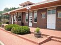
The Chesapeake and Ohio Railway served Olive Hill and many other places on the railroad's Lexington Subdivision (running from Ashland to Lexington). The C&O merged into the Chessie System, which CSX Transportation later bought out, and after that CSX pulled up the railroad in the mid-1980s. Olive Hill retained and restored a passenger depot as well as a caboose ("John Hop Brown" Memorial Park). [8]

According to George C. Wright in his A History of Blacks in Kentucky, volume 2, "In the small community of Olive Hill in 1917, several hundred white laborers at the brick-making General Refractories Company threatened to strike unless recently employed blacks were dismissed. After first refusing to meet with the leaders of the disgruntled workers, the company managers acceded to their demand and fired all the black workers,"(p. 14).

Geography

Olive Hill is located in western Carter County primarily on the north side of Tygarts Creek, a tributary of the Ohio River. U.S. Route 60 passes through the city, leading east 14 miles (23 km) to Grayson, the Carter County seat, and west 18 miles (29 km) to Morehead. Interstate 64 passes 3 miles (5 km) north of Olive Hill, leading east 44 miles (71 km) to Huntington, West Virginia, and west 84 miles (135 km) to Lexington.

According to the United States Census Bureau, Olive Hill has a total area of 1.8 square miles (4.7 km2), of which 0.027 square miles (0.07 km2), or 1.51%, is water. [6]

Demographics

As of the census [9] of 2000, there were 1,813 people, 791 households, and 488 families residing in the city. The population density was 904.1 people per square mile (349.1 people/km2). There were 886 housing units at an average density of 441.8 per square mile (170.6/km2). The racial makeup of the city was 98.73% White, 0.17% African American, 0.50% Native American, 0.11% from other races, and 0.50% from two or more races. Hispanic or Latino of any race were 0.61% of the population.

Historical population
CensusPop.Note
1880 56
1890 186232.1%
1900 29156.5%
1910 1,182306.2%
1920 1,39518.0%
1930 1,4846.4%
1940 1,4910.5%
1950 1,351−9.4%
1960 1,3983.5%
1970 1,197−14.4%
1980 2,539112.1%
1990 1,809−28.8%
2000 1,8130.2%
2010 1,599−11.8%
2020 1,580−1.2%
2022 (est.)1,555 [10] −1.6%
U.S. Decennial Census [11]

There were 791 households, out of which 26.5% had children under the age of 18 living with them, 44.5% were married couples living together, 14.5% had a female householder with no husband present, and 38.2% were non-families. 34.8% of all households were made up of individuals, and 18.6% had someone living alone who was 65 years of age or older. The average household size was 2.28 and the average family size was 2.93.

In the city, the population was spread out, with 24.5% under the age of 18, 8.3% from 18 to 24, 24.4% from 25 to 44, 24.4% from 45 to 64, and 18.4% who were 65 years of age or older. The median age was 39 years. For every 100 females, there were 83.7 males. For every 100 females age 18 and over, there were 78.0 males.

The median income for a household in the city was $22,958, and the median income for a family was $31,071. Males had a median income of $24,063 versus $19,191 for females. The per capita income for the city was $12,628. About 16.7% of families and 24.8% of the population were below the poverty line, including 35.1% of those under age 18 and 23.5% of those age 65 or over.

Education

Public education in Olive Hill is administered by Carter County School District, which operates Olive Hill Elementary School, West Carter Middle School, and West Carter High School.

Olive Hill has a public library, a branch of the Carter County Public Library, housed on the third floor of the former Olive Hill High School. [12]

Notable people

Olive Hill is the birthplace of country music singer and writer Tom T. Hall (The Story Teller), a fact that is noted on the "Welcome to Olive Hill" signs on the edges of town.

See also

Related Research Articles

<span class="mw-page-title-main">Wood County, West Virginia</span> County in West Virginia, United States

Wood County is a county in the U.S. state of West Virginia. As of the 2020 census, the population was 84,296, making it West Virginia's fifth-most populous county. Its county seat is Parkersburg. The county was formed in 1798 from the western part of Harrison County and named for James Wood, governor of Virginia from 1796 to 1799.

<span class="mw-page-title-main">Casey County, Kentucky</span> County in Kentucky, United States

Casey County is a county located in the U.S. Commonwealth of Kentucky. As of the 2020 census, the population was 15,941. Its county seat is Liberty. The county was formed in 1806 from the western part of Lincoln County and named for Colonel William Casey, a pioneer settler who moved his family to Kentucky in 1779. It is the only Kentucky county entirely in the Knobs region. Casey County is home to annual Casey County Apple Festival, and is a prohibition or dry county. It is considered part of the Appalachian region of Kentucky.

<span class="mw-page-title-main">Carter County, Kentucky</span> County in Kentucky, United States

Carter County is a county located in the U.S. state of Kentucky. As of the 2020 census, the population was 26,627. Its county seat is Grayson. Carter County is in the Huntington-Ashland, WV-KY-OH Metropolitan Statistical Area. It is home to Carter Caves State Resort Park.

<span class="mw-page-title-main">Morgantown, Kentucky</span> City in Kentucky, United States

Morgantown is a home rule-class city in, and the seat of Butler County, Kentucky, United States. The population was 2,471 at the time of the 2020 Census.

<span class="mw-page-title-main">Grayson, Kentucky</span> City in Kentucky, United States

Grayson is a home rule-class city in and the county seat of Carter County, Kentucky, United States, on U.S. Route 60 and Interstate 64 in the state's northeastern region. It is approximately 21 miles west of Ashland. Within the city limits, the population was 4,217 at the 2010 census. Along with Carter County, the city is closely associated with the nearby Huntington-Ashland, WV-KY-OH Metropolitan Statistical Area and is often erroneously included in the MSA being just 9 miles west of the M.S.A's western boundary.

<span class="mw-page-title-main">Winchester, Kentucky</span> City in Kentucky, United States

Winchester is a home rule-class city in and the county seat of Clark County, Kentucky, United States. The population was 19,134 at the 2020 census. It is part of the Lexington-Fayette, KY Metropolitan Statistical Area. Winchester is located roughly halfway between Lexington and Mt. Sterling.

<span class="mw-page-title-main">Lancaster, Kentucky</span> City in Kentucky, United States

Lancaster is a home rule-class city in Garrard County, Kentucky, in the United States. It is the seat of its county. As of the year 2020 U.S. census, the city population was 3,901.

<span class="mw-page-title-main">Greenup, Kentucky</span> City in Kentucky, United States

Greenup is a home rule-class city located at the confluence of the Little Sandy River with the Ohio River in Greenup County, Kentucky, United States. The population was 1,188 at the 2010 census. Greenup is one of three county seats in the Commonwealth of Kentucky to share its name with its county; the other two being Harlan and Henderson.

<span class="mw-page-title-main">Raceland, Kentucky</span> City in Kentucky, United States

Raceland is a home rule-class city in Greenup County, Kentucky, United States, in the Ohio River valley. As of the 2010 census, the population was 2,424. It is part of the Huntington–Ashland metropolitan area.

<span class="mw-page-title-main">Russell, Kentucky</span> City in Kentucky, United States

Russell is a home rule-class city on the south bank of the Ohio River in Greenup County, Kentucky, United States. The population was 3,380 as of the 2010 census, down from 3,645 in 2000. Russell is a suburb of Ashland and part of the Huntington-Ashland-Ironton metropolitan area. It has close economic affiliations with its neighbors, Ashland and Flatwoods in Kentucky and Ironton, Ohio.

<span class="mw-page-title-main">South Shore, Kentucky</span> City in Kentucky, United States

South Shore is a home rule-class city in Greenup County, Kentucky, United States. The population was 1,122 at the 2010 census, down from 1,226 in 2000. It is located along the Ohio River across from Portsmouth, Ohio, at the mouth of Tygarts Creek. South Shore is a part of the Huntington-Ashland, WV-KY-OH, Metropolitan Statistical Area (MSA).

<span class="mw-page-title-main">Clinton, Kentucky</span> City in Kentucky, United States

Clinton is a home rule-class city and the county seat of Hickman County, Kentucky, United States. The population was 1,388 at the 2010 census, a decline from 1,415 in 2000.

<span class="mw-page-title-main">Park Hills, Kentucky</span> City in Kentucky, United States

Park Hills is a home rule-class city in Kenton County, Kentucky, United States. The population was 3,162 at the 2020 census. It is a suburb of the Cincinnati metropolitan area. Much of the city was listed on the National Register of Historic Places in 2008 as the Park Hills Historic District.

<span class="mw-page-title-main">Warfield, Kentucky</span> City in Kentucky, United States

Warfield is a home rule-class city in Martin County, Kentucky, United States. The population was 264 at the 2020 census.

<span class="mw-page-title-main">Jeffersonville, Kentucky</span> City in Kentucky, United States

Jeffersonville is a home rule-class city in Montgomery County, Kentucky, in the United States. The population was 1,708 as of the 2020 census, up from 1,506 in 2010. It is part of the Mount Sterling micropolitan area.

<span class="mw-page-title-main">Livingston, Kentucky</span> City in Kentucky, United States

Livingston is a home rule-class city in Rockcastle County, Kentucky, in the United States. The population was 226 during the 2010 U.S. census. It is part of the Richmond-Berea micropolitan area.

<span class="mw-page-title-main">Mill Creek, West Virginia</span> Town in West Virginia, United States

Mill Creek is a town in Randolph County, West Virginia, United States, along the Tygart Valley River. The population was 563 at the 2020 census.

<span class="mw-page-title-main">Walton, Kentucky</span> City in Kentucky, United States

Walton is a home rule-class city in Boone and Kenton counties in the U.S. state of Kentucky. The population was 5,460 at the 2020 census.

<span class="mw-page-title-main">Sparta, Kentucky</span> City in Kentucky, United States

Sparta is a home rule-class city in Gallatin and Owen counties in the U.S. state of Kentucky. The population was 231 at the 2010 census.

<span class="mw-page-title-main">Prospect, Kentucky</span> City in Kentucky, United States

Prospect is a home rule-class city in Jefferson and Oldham counties in the U.S. state of Kentucky. The Jefferson County portion is a part of the Louisville Metro government. The population was 4,592 as of the 2020 census, down from 4,698 at the time of the 2010 census. It is one of the wealthiest communities in Kentucky.

References

  1. Commonwealth of Kentucky. Office of the Secretary of State. Land Office. "Olive Hill, Kentucky". Accessed 18 September 2013.
  2. "2020 U.S. Gazetteer Files". United States Census Bureau. Retrieved March 18, 2022.
  3. 1 2 U.S. Geological Survey Geographic Names Information System: Olive Hill, Kentucky
  4. "Annual Estimates of the Resident Population for Incorporated Places in Kentucky: April 1, 2020 to July 1, 2022". United States Census Bureau. Retrieved May 26, 2023.
  5. "Summary and Reference Guide to House Bill 331 City Classification Reform" (PDF). Kentucky League of Cities. Archived (PDF) from the original on November 11, 2014. Retrieved December 30, 2014.
  6. 1 2 "Geographic Identifiers: 2010 Demographic Profile Data (G001): Olive Hill city, Kentucky". U.S. Census Bureau, American Factfinder. Archived from the original on February 12, 2020. Retrieved August 11, 2014.
  7. Rennick, Robert M. (1988). "Place Names". Kentucky Place Names. Lexington, Kentucky: The University Press of Kentucky. ISBN   0-8131-0179-4. Retrieved on 2010-11-05
  8. "Archived copy" (PDF). Archived from the original (PDF) on August 10, 2014. Retrieved November 24, 2012.{{cite web}}: CS1 maint: archived copy as title (link)
  9. "U.S. Census website". United States Census Bureau . Retrieved January 31, 2008.
  10. "Annual Estimates of the Resident Population for Incorporated Places in Kentucky: April 1, 2020 to July 1, 2022". United States Census Bureau. Retrieved May 26, 2023.
  11. "Census of Population and Housing". Census.gov. Retrieved June 4, 2015.
  12. "Kentucky Public Library Directory". Kentucky Department for Libraries and Archives. Archived from the original on January 11, 2019. Retrieved June 5, 2019.