Burlington, Ohio

Last updated
Burlington, Ohio
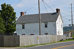
William C. Johnston House in Burlington.jpg
William C. Johnston House
OHMap-doton-Burlington.png
Location of Burlington, Ohio
Coordinates: 38°24′46″N82°30′40″W / 38.41278°N 82.51111°W / 38.41278; -82.51111
Country United States
State Ohio
County Lawrence
Township Fayette
Area
[1]
  Total1.42 sq mi (3.67 km2)
  Land1.39 sq mi (3.61 km2)
  Water0.02 sq mi (0.06 km2)
Elevation
[2]
554 ft (169 m)
Population
 (2020)
  Total2,416
  Density1,733.14/sq mi (669.34/km2)
Time zone UTC-5 (Eastern (EST))
  Summer (DST) UTC-4 (EDT)
ZIP Code
45680 (South Point)
FIPS code 39-10352 [3]
GNIS feature ID2393357 [2]

Burlington is an unincorporated community and census-designated place in Lawrence County, Ohio, United States, along the Ohio River. The population was 2,416 at the 2020 census. Connected to neighboring Huntington, West Virginia and connected via the West Huntington Bridge over the Ohio River, it is part of the Huntington–Ashland metropolitan area. Burlington was once the leading community of Lawrence County, being the first county seat and the location of the county's first post office.

Contents

History

Beginning in 1817, Burlington was the first and previous county seat of Lawrence County, and its post office the only one in the county until 1821. [4] The town was named after Burlington, Vermont. [5] [6]

The Burlington 37 Cemetery, [7] the William C. Johnston House and General Store, and the Old Lawrence County Jail, [8] [9] all located in Burlington, are listed on the National Register of Historic Places, as is the nearby Macedonia Church. [10]

Geography

Burlington is located in southern Lawrence County. [2]

According to the United States Census Bureau, the CDP has a total area of 1.4 square miles (3.6 km2), all land. According to Census 2000: Incorporated Places/Census Designated Places, Cartographic Boundary Files - Ohio, the southern boundary of the Burlington CDP ends at the current Ohio River northern shoreline, the northern boundary is U.S. Route 52, the western boundary is the village of South Point, and the eastern boundary is the neighboring Sybene, Ohio. [11]

While the village of South Point claims to be the southernmost point in Ohio, [12] Burlington's southernmost point, just upstream from South Point's southern point, is plainly a short distance farther south. [13] [14]

Surrounding communities

Located on the southern shoreline of Fayette Township, Burlington borders the following communities: [14]

Union Township and the village of Chesapeake lie a short distance upstream (east), and Perry Township lies a short distance downstream (northwest).

Demographics

Historical population
CensusPop.Note
2000 2,794
2010 2,676−4.2%
2020 2,416−9.7%
U.S. Decennial Census [16] [17]

As of the census [3] of 2000, there were 2,794 people, 1,127 households, and 734 families residing in the CDP. The population density was 1,961.1 inhabitants per square mile (757.2/km2). There were 1,242 housing units at an average density of 871.8 per square mile (336.6/km2). The racial makeup of the CDP was 87.33% White, 9.48% African American, 0.25% Native American, 0.11% Asian, 0.47% from other races, and 2.36% from two or more races. Hispanic or Latino of any race were 1.72% of the population.

There were 1,127 households, out of which 25.9% had children under the age of 18 living with them, 46.8% were married couples living together, 13.6% had a female householder with no husband present, and 34.8% were non-families. 30.7% of all households were made up of individuals, and 15.0% had someone living alone who was 65 years of age or older. The average household size was 2.29 and the average family size was 2.84.

In the CDP the population was spread out, with 20.1% under the age of 18, 8.1% from 18 to 24, 23.4% from 25 to 44, 25.4% from 45 to 64, and 23.0% who were 65 years of age or older. The median age was 44 years. For every 100 females, there were 82.4 males. For every 100 females age 18 and over, there were 77.2 males.

The median income for a household in the CDP was $23,995, and the median income for a family was $29,934. Males had a median income of $28,750 versus $23,285 for females. The per capita income for the CDP was $15,619. About 14.3% of families and 16.6% of the population were below the poverty line, including 20.4% of those under age 18 and 8.7% of those age 65 or over.

Education

Burlington is part of the South Point Local School District and maintains its own elementary school, Burlington Elementary School, in addition to South Point Middle School and South Point High School in neighboring South Point. [18]

Transportation

U.S. Route 52 passes through the northern side of the community. [19]

Local airports include the Tri-State Airport in the Huntington area and the Lawrence County Airpark in Lawrence County, located at the eastern edge of the community. [19] [20]

See also

Related Research Articles

<span class="mw-page-title-main">Wood County, West Virginia</span> County in West Virginia, United States

Wood County is a county in the U.S. state of West Virginia. As of the 2020 census, the population was 84,296, making it West Virginia's fifth-most populous county. Its county seat is Parkersburg. The county was formed in 1798 from the western part of Harrison County and named for James Wood, governor of Virginia from 1796 to 1799.

<span class="mw-page-title-main">Wayne County, West Virginia</span> County in West Virginia, United States

Wayne County is the westernmost county in the U.S. state of West Virginia. As of the 2020 census, the population was 38,982. Its county seat is Wayne. The county was founded in 1842 and named for General "Mad" Anthony Wayne.

<span class="mw-page-title-main">Mason County, West Virginia</span> County in West Virginia, United States

Mason County is a county in the U.S. state of West Virginia. As of the 2020 census, the population was 25,453. Its county seat and largest city is Point Pleasant. The county was founded in 1804 and named for George Mason, delegate to the U.S. Constitutional Convention. Before the Civil War, the county was in the State of Virginia.

<span class="mw-page-title-main">Washington County, Ohio</span> County in Ohio, United States

Washington County is a county located in the southeastern part of the U.S. state of Ohio. As of the 2020 census, the population was 59,711. Its county seat is Marietta. The county, the oldest in the state, is named for George Washington. Washington County comprises the Marietta, OH Micropolitan Statistical Area, which is also included in the Parkersburg-Marietta-Vienna, WV-OH Combined Statistical Area.

<span class="mw-page-title-main">Monroe County, Ohio</span> County in Ohio, United States

Monroe County is a county located on the eastern border of the U.S. state of Ohio, across the Ohio River from West Virginia. As of the 2020 census, the population was 13,385, making it the second-least populous county in Ohio. Its county seat is Woodsfield. The county was created in 1813 and later organized in 1815.

<span class="mw-page-title-main">Lawrence County, Ohio</span> County in Ohio, United States

Lawrence County is the southernmost county located in the U.S. state of Ohio. As of the 2020 census, the population was 58,240. Its county seat is Ironton. The county was created in 1815 and later organized in 1817. It is named for James Lawrence, the naval officer famous for the line "do not give up the ship". Lawrence County is part of the Huntington–Ashland metropolitan area.

<span class="mw-page-title-main">Burlington, Kentucky</span> Census-designated place in Boone County, Kentucky, United States

Burlington is a census-designated place (CDP) in and the county seat of Boone County, Kentucky, United States. The population was 17,318 at the 2020 census.

<span class="mw-page-title-main">Proctorville, Ohio</span> Village in Ohio, United States

Proctorville is a village in Lawrence County, Ohio, United States, along the Ohio River. The population was 523 at the 2020 census. The East End Bridge connects Proctorville to Huntington, West Virginia across the Ohio River.

<span class="mw-page-title-main">South Point, Ohio</span> Village in Ohio, United States

South Point is a village in Lawrence County, Ohio, United States, along the Ohio River. The population was 3,836 at the 2020 census. It is part of the Huntington–Ashland metropolitan area.

<span class="mw-page-title-main">Huntington, Virginia</span> Census-designated place in Virginia, United States

Huntington is a census-designated place (CDP) in Fairfax County, Virginia, United States. The population was 11,267 at the 2010 census. It is located next to the southern border of the city of Alexandria and is part of the Washington metropolitan area. Its main component is the namesake Huntington subdivision, a late-1940s neighborhood of mainly duplex homes.

<span class="mw-page-title-main">Keokee, Virginia</span> Census-designated place in Virginia, United States

Keokee is an unincorporated community and census-designated place (CDP) in Lee County, Virginia, United States. The population was 416 at the 2010 census.

<span class="mw-page-title-main">Newell, West Virginia</span> Census-designated place in West Virginia, United States

Newell is an unincorporated community and census-designated place in northern Hancock County, West Virginia, United States, along the Ohio River. The population was 1,203 at the 2020 census. It is part of the Weirton–Steubenville metropolitan area and is best known as the home to the Fiesta Tableware Company.

<span class="mw-page-title-main">Mallory, West Virginia</span> Census-designated place in West Virginia, United States

Mallory is a census-designated place (CDP) in Logan County, West Virginia, United States. The population was 1,654 at the 2010 census. The CDP contains the unincorporated communities, from west to east, of Huff Junction, Mallory, Davin, Mineral City, Claypool, Combs Addition, and Gillman Bottom.

<span class="mw-page-title-main">Mount Gay-Shamrock, West Virginia</span> Census-designated place in West Virginia, United States

Mount Gay-Shamrock is a census-designated place (CDP) in Logan County, West Virginia, United States.

<span class="mw-page-title-main">Switzer, West Virginia</span> Census-designated place in West Virginia, United States

Switzer is an unincorporated community and census-designated place (CDP) in Logan County, West Virginia, United States. The CDP includes the neighboring unincorporated community of Micco. The total CDP population was 595 at the 2010 census.

<span class="mw-page-title-main">Boaz, West Virginia</span> CDP in West Virginia, United States

Boaz is a census-designated place (CDP) in Wood County, West Virginia, United States. It is part of the Parkersburg-Marietta-Vienna, WV-OH Metropolitan Statistical Area. As of the 2020 census, the CDP population was 1,321.

<span class="mw-page-title-main">Mineralwells, West Virginia</span> CDP in West Virginia, United States

Mineralwells, also known as Mineral Wells, is a census-designated place (CDP) in Wood County, West Virginia, United States. It is part of the Parkersburg-Marietta-Vienna, WV-OH Metropolitan Statistical Area. The population was 1,950 at the 2010 census. The population was 2216 at the 2021 census.

<span class="mw-page-title-main">Bradford (CDP), Vermont</span> Census-designated places in Vermont, United States

Bradford is a census-designated places in the town of Bradford, Orange County, Vermont, United States. The population was 907 at the 2020 census. The village disincorporated on December 1, 2004. The village became a census-designated place in 2008. The central commercial and residential portion of the village is listed on the National Register of Historic Places as the Bradford Village Historic District.

<span class="mw-page-title-main">Huntington (CDP), New York</span> Place in New York, United States

Huntington is a hamlet and census-designated place (CDP) located within the Town of Huntington in Suffolk County, on the North Shore of Long Island, in New York, United States. The population was 18,406 at the 2010 census. The hamlet serves as the Town Seat of the Town of Huntington.

<span class="mw-page-title-main">New Burlington, Hamilton County, Ohio</span> Census-designated place in Ohio, United States

New Burlington is a census-designated place (CDP) in Springfield Township, Hamilton County, Ohio, United States. The population was 5,049 at the 2020 census.

References

  1. "ArcGIS REST Services Directory". United States Census Bureau. Retrieved September 20, 2022.
  2. 1 2 3 U.S. Geological Survey Geographic Names Information System: Burlington, Ohio
  3. 1 2 "U.S. Census website". United States Census Bureau . Retrieved 2008-01-31.
  4. "History of Burlington". The Lawrence Register. Archived from the original on 2006-02-05. Retrieved 2006-03-01.
  5. Ironton Register newspaper, July 11, 1895
  6. "Origin of Burlington's Name". The Lawrence Register, Genealogical and Historical. Archived from the original on 2008-07-08. Retrieved 2008-06-30.
  7. "Burlington 37 Monument". Greater Lawrence County Chamber of Commerce. Archived from the original on 2008-07-02. Retrieved 2008-07-03.
  8. "Burlington Jail". Ohio Historical Society.
  9. "Ohio Historic Inventory - Burlington Jail". Ohio Historic Preservation Office, Ohio Historical Center. Archived from the original (TIF) on 2007-10-21. Retrieved 2008-07-03.
  10. National Register of Historic Places — Lawrence County, Ohio, National Register. Accessed 2008-06-30.
  11. "Census 2000: Incorporated Places/Census Designated Places Cartographic Boundary Files". United States Census Bureau.
  12. "Information about South Point". South Point. Archived from the original on 2008-07-24. Retrieved 2008-07-03.
  13. County Subdivision Outline Map, United States Census Bureau, 2000. Accessed 2008-08-09.
  14. 1 2 "Census 2000 Tract Outline Map - Ohio - Lawrence County" (PDF). United States Census Bureau.
  15. 1 2 "Census 2000 Tract Outline Map - West Virginia - Wayne County" (PDF). United States Census Bureau.
  16. "Census of Population and Housing". Census.gov. Retrieved June 4, 2016.
  17. "Total Population: 2010 Census DEC Summary File 1 (P1), Burlington CDP, Ohio". data.census.gov. U.S. Census Bureau. Retrieved July 8, 2020.
  18. South Point Local School District — Burlington Elementary School Archived 2008-06-03 at the Wayback Machine , South Point Local School District, 2007. Accessed 2008-07-01.
  19. 1 2 DeLorme. Ohio Atlas & Gazetteer. 7th ed. Yarmouth: DeLorme, 2004, p. 87. ISBN 0-89933-281-1
  20. DeLorme. West Virginia Atlas & Gazetteer. 4th ed. Yarmouth: DeLorme, 2007, p. 41. ISBN   0-89933-327-3.