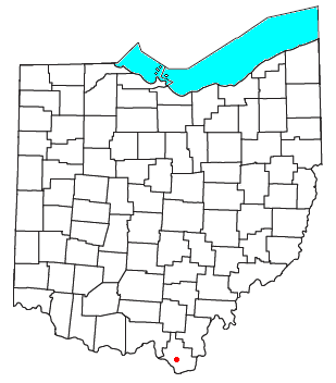
Kitts Hill is an unincorporated community in western Lawrence Township, Lawrence County, Ohio, United States. [1] It has a post office with the ZIP code 45645. [2] It lies along State Route 141 northeast of the city of Ironton, the county seat of Lawrence County. It has a community center that was previously Deering Local School District in the area. The majority of Pre-K through 12th grade education is provided by the Rock Hill Local School District, although very small portions of the area are served by the Dawson-Bryant Local School District.
Kitts Hill is named for the family of farmer George Edward "Charles" Kitts, who was born in Belmont, and died at Kitts Hill around 1876. [3] His son, Edward Franklin Kitts and wife Mary Ann nee-Farson, followed. Their daughter Louisa Esther married Willis Crowe, whose family controlled the farm for much of the 20th century. [4]
Lawrence County is the southernmost county of the U.S. state of Ohio. As of the 2020 census, the population was 58,240. Its county seat is Ironton. The county was created in 1815 and later organized in 1817. It is named for James Lawrence, the naval officer famous for the line "do not give up the ship". Lawrence County is part of the Huntington–Ashland metropolitan area.
Lutz is an unincorporated community in Hillsborough County and Pasco County, Florida, United States, 15 miles (24 km) north of Tampa. While there is a census-designated area of Lutz, the community itself extends beyond those boundaries into other census-designated areas.
Allouez Township is a civil township of Keweenaw County in the U.S. state of Michigan. The population was 1,428 at the 2020 census.
Harris Hill is a hamlet and census-designated place (CDP) located in the town of Clarence in Erie County, New York, United States. The population was 5,508 at the 2010 census. It is part of the Buffalo-Niagara Falls metropolitan area. The region is named after Asa Harris, a former officer in the American Colonial Army, who established a tavern near the top of a low hill northeast of Buffalo.
Bronxville is a village in Westchester County, New York, United States, located approximately 15 miles (24 km) north of Midtown Manhattan. It is part of the town of Eastchester. The village comprises one square mile (2.5 km2) of land in its entirety, approximately 20% of the town of Eastchester. As of the 2020 U.S. census, Bronxville had a population of 6,656. In 2016, Bronxville was rated by CNBC as the most expensive suburb of any of the U.S. ten largest cities, with a median home value of $2.33 million.
Bunker Hill Village is a city in Harris County, Texas, United States, part of Houston–The Woodlands–Sugar Land metropolitan area. The population was 3,822 at the 2020 census. It is part of a collection of upscale residential communities in west Houston known as the Memorial Villages. As of 2010, Bunker Hill Village was the sixth wealthiest place in Texas. Also, Bunker Hill Village is one of Forbes' top 25 places to retire rich.
Fall Branch is a census-designated place (CDP) in Washington and Greene counties in the U.S. state of Tennessee. The population was 1,291 at the 2010 census. Some areas in Sullivan also use the Fall Branch ZIP code.
Leicester is an unincorporated community in Buncombe County, North Carolina United States; although incorporating was proposed in 2007 and an incorporation bill was briefly filed in the North Carolina General Assembly, no measure has been adopted. Leicester is part of the Asheville Metropolitan Statistical Area. As of 2007, Leicester's population is 12,514 people. Since 2000, it has had a population growth of 16.26 percent.
Bidwell is a small unincorporated community in northwestern Springfield Township, Gallia County, Ohio, United States, Although unincorporated, it has its own ZIP Code of 45614. Bidwell is located eleven miles from the county seat, Gallipolis. It is at an elevation of 735 feet.
Minford is a census-designated place located on the border of Harrison and Madison townships in northeastern Scioto County, Ohio, United States, about 14 miles (23 km) northeast of the county seat of Portsmouth. As of the 2020 census, it had a population of 641.
Patton is an unincorporated community in the southeastern part of Union Township in northern Bollinger County in Southeast Missouri, United States. It is located on State Highway 51, approximately one mile south of the intersection with Route 72 along Little Whitewater Creek and 15 miles north of Marble Hill. The ZIP Code for Patton is 63662.
Old Town is an unincorporated community in Dixie County, Florida, United States, located at US 19–ALT 27-98 and State Road 349. The ZIP Code for Old Town is 32680.
Lewis Center is an unincorporated community in northwestern Orange Township, Delaware County, Ohio, United States, in the Columbus, OH Metropolitan Statistical Area.
Willow Wood is an unincorporated community in western Windsor Township, Lawrence County, Ohio, United States, along Symmes Creek. It has a post office with the ZIP code 45696.
Pedro is an unincorporated community in central Elizabeth Township, Lawrence County, Ohio, United States. It has a post office with ZIP code 45659.
Patriot is an unincorporated community in southern Perry Township, Gallia County, Ohio, United States. It has a post office with the ZIP code 45658.
Kerr is an unincorporated community in southeastern Springfield Township, Gallia County, Ohio, United States. It has a post office with the ZIP code 45643.
Boyd County is a county located in the U.S. Commonwealth of Kentucky. As of the 2020 census, its population was 48,261. The county seat is Catlettsburg, and its largest city is Ashland. The county was formed in 1860. The county spans 160 square miles (410 km2), and is found at the northeastern edge of the state, near the Ohio River and Big Sandy River and situated in mountainous Appalachia. Boyd County is in the Huntington-Ashland, WV-KY-OH metropolitan statistical area.
Saint Rose is a village in Clinton County, Illinois, United States. Saint Rose is 5 miles (8.0 km) north-northwest of Breese. The population was 459 as of the 2020 census.
Elverta is a census-designated place in Sacramento County, California. It is part of the Sacramento metropolitan area, which includes Sacramento, Arden-Arcade, and Roseville. It is about 20 miles (32 km) from Sacramento, 2.5 miles (4.0 km) from Rio Linda, 6 miles (9.7 km) from Roseville, and 8.0 miles (12.9 km) from Antelope. The population was 5,492 as of the 2010 census.
{{cite web}}
: Missing or empty |title=
(help)38°33′41″N82°34′39″W / 38.56139°N 82.57750°W