Bromley, Kentucky

Last updated

Bromley, Kentucky
Pleasant Run Stone House I.jpg
Pleasant Run Stone House I south of Bromley
Kenton County Kentucky Incorporated and Unincorporated areas Bromley Highlighted 2109856.svg
Location of Bromley in Kenton County, Kentucky
Coordinates: 39°04′49″N84°33′47″W / 39.08028°N 84.56306°W / 39.08028; -84.56306
Country United States
State Kentucky
County Kenton
Government
  MayorMike Denham [1]
Area
[2]
  Total0.51 sq mi (1.31 km2)
  Land0.38 sq mi (0.97 km2)
  Water0.13 sq mi (0.34 km2)
Elevation
[3]
505 ft (154 m)
Population
 (2020)
  Total724
  Density1,930.67/sq mi (745.92/km2)
Time zone UTC-5 (Eastern (EST))
  Summer (DST) UTC-4 (EDT)
ZIP codes
41016-41017
Area code 859
FIPS code 21-09856
GNIS feature ID2403932 [3]
Website www.cityofbromley.com

Bromley is a home rule-class city in Kenton County, Kentucky, United States, along the Ohio River. The population was 724 at the 2020 census. It is part of the Cincinnati metropolitan area.

Contents

History

The settlement of Bromley can be traced to 1784, when Prettyman Merry received a land grant from the United States government of 2,000 acres (8.1 km2). Soon thereafter, the Merry family began constructing a home on the property. This home still stands today on Shelby Street.

The Commonwealth of Kentucky officially approved the incorporation of the city of Bromley on May 23, 1890. [4]

On December 14, 2023, the city became the site of a workplace disaster at Sanitation 1 near 2 Steve Tanner Street. Two male contractors were drowned, and third was hospitalized. [5]

Geography

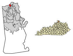
Bromley is located on the northern edge of Kenton County. It sits on the south bank of the Ohio River and is bordered to the northeast (upstream) by the city of Ludlow and to the southwest (downstream) by the city of Villa Hills. To the south is Crescent Springs, and to the north, across the river in Ohio, is the city of Cincinnati. The nearest river crossing is the Brent Spence Bridge 3 miles (5 km) to the east, carrying Interstates 71 and 75.

Kentucky Route 8 passes through the center of Bromley, leading northeast into Ludlow and Covington and west along the river through Villa Hills to Taylorsport.

According to the United States Census Bureau, Bromley has a total area of 0.44 square miles (1.13 km2), of which 0.34 square miles (0.87 km2) are land and 0.10 square miles (0.26 km2), or 22.75%, are water. [6]

Several Bromley streets bear the names of prominent Kentucky historical figures, including Shelby Street (Isaac Shelby), Boone Street (Daniel Boone) and Kenton Street (Simon Kenton). [7]

Demographics

Historical population
CensusPop.Note
1900 543
1910 81950.8%
1920 736−10.1%
1930 1,01738.2%
1940 876−13.9%
1950 98011.9%
1960 9981.8%
1970 1,0697.1%
1980 844−21.0%
1990 1,13734.7%
2000 838−26.3%
2010 763−8.9%
2020 724−5.1%
U.S. Decennial Census [8] [6]

As of the census [9] of 2000, there were 838 people, 342 households, and 221 families residing in the city. The population density was 2,702.8 inhabitants per square mile (1,043.6/km2). There were 362 housing units at an average density of 1,167.5 per square mile (450.8/km2). The racial makeup of the city was 98.57% White, 0.48% Native American, 0.36% Asian, 0.12% from other races, and 0.48% from two or more races. Hispanic or Latino of any race were 0.48% of the population.

There were 342 households, out of which 30.4% had children under the age of 18 living with them, 43.0% were married couples living together, 15.5% had a female householder with no husband present, and 35.1% were non-families. 29.8% of all households were made up of individuals, and 12.6% had someone living alone who was 65 years of age or older. The average household size was 2.45 and the average family size was 3.07.

In the city, the population was spread out, with 26.5% under the age of 18, 9.5% from 18 to 24, 30.7% from 25 to 44, 19.1% from 45 to 64, and 14.2% who were 65 years of age or older. The median age was 34 years. For every 100 females, there were 94.9 males. For every 100 females age 18 and over, there were 91.9 males.

The median income for a household in the city was $31,563, and the median income for a family was $40,481. Males had a median income of $30,486 versus $24,886 for females. The per capita income for the city was $14,315. About 10.3% of families and 11.1% of the population were below the poverty line, including 9.9% of those under age 18 and 9.2% of those age 65 or over.

Education

The majority of Bromley is in the Ludlow Independent School District. Some parcels of land are in the Kenton County School District. [10]

Related Research Articles

<span class="mw-page-title-main">Kenton County, Kentucky</span> County in Kentucky, United States

Kenton County is a county located in the northern part of the Commonwealth of Kentucky. As of the 2020 census, the population was 169,064, making it the third most populous county in Kentucky. Its county seats are Covington and Independence. It was, until November 24, 2010, the only county in Kentucky to have two legally recognized county seats. The county was formed in 1840 and is named for Simon Kenton, a frontiersman notable in the early history of the state.

<span class="mw-page-title-main">Cold Spring, Kentucky</span> City in Kentucky, United States

Cold Spring is a home rule-class city in Campbell County, Kentucky, in the United States. The population was 6,216 at the 2020 census. It is part of the Cincinnati-Northern Kentucky metropolitan area.

<span class="mw-page-title-main">Crescent Springs, Kentucky</span> City in Kentucky, United States

Crescent Springs is a home rule-class city in Kenton County, Kentucky, United States. The population was 4,319 at the 2020 census.

<span class="mw-page-title-main">Erlanger, Kentucky</span> City in Kentucky, United States

Erlanger is a home rule-class city in Kenton County, Kentucky, United States. It had a 2020 census population of 19,611. Erlanger is part of the Cincinnati-Middletown, OH-KY-IN Metropolitan Statistical Area.

<span class="mw-page-title-main">Fairview, Kenton County, Kentucky</span> City in Kentucky, United States

Fairview is a home rule-class city in Kenton County, Kentucky, United States. The city is a suburb of Cincinnati. It was incorporated by the state assembly in 1957 to avoid annexation by Covington. The population was 144 at the 2020 census.

<span class="mw-page-title-main">Fort Mitchell, Kentucky</span> City in Kentucky, United States

Fort Mitchell is a home rule-class city in Kenton County, Kentucky, United States. The population was 8,702 at the 2020 census. It is part of the Cincinnati metropolitan area.

<span class="mw-page-title-main">Fort Wright, Kentucky</span> City in Kentucky, United States

Fort Wright is a home rule-class city in Kenton County, Kentucky, in the United States. The population was 5,851 at the 2020 census. It is part of the Cincinnati metropolitan area.

<span class="mw-page-title-main">Independence, Kentucky</span> City in Kentucky, United States

Independence is a home rule-class city in Kenton County, Kentucky, United States. It is one of its county's two seats of government. The population was 28,676 at the time of the 2020 census. It is the third largest city in Northern Kentucky after Covington and Florence, and is part of the Cincinnati metropolitan area.

<span class="mw-page-title-main">Kenton Vale, Kentucky</span> City in Kentucky, United States

Kenton Vale is a home rule-class city in Kenton County, Kentucky, in the United States. The population was 105 at the 2020 census.

<span class="mw-page-title-main">Ludlow, Kentucky</span> City in Kentucky, United States

Ludlow is a home rule-class city in Kenton County, Kentucky, United States, along the Ohio River. The population was 4,385 at the 2020 census. It is a suburb of the Cincinnati metropolitan area. It received its greatest period of early growth as a rail station.

<span class="mw-page-title-main">Ryland Heights, Kentucky</span> City in Kentucky, United States

Ryland Heights is a home rule-class city in Kenton County, Kentucky, in the United States. The population was 922 at the 2020 census.

<span class="mw-page-title-main">Taylor Mill, Kentucky</span> City in Kentucky, United States

Taylor Mill is a home rule-class city in Kenton County, Kentucky, in the United States. The population was 6,873 at the 2020 census.

<span class="mw-page-title-main">Villa Hills, Kentucky</span> City in Kentucky, United States

Villa Hills is a home rule-class city in Kenton County, Kentucky along the Ohio River. The population was 7,310 at the 2020 census.

<span class="mw-page-title-main">Visalia, Kentucky</span> Unincorporated community in Kentucky, United States

Visalia was a city in Kenton County, Kentucky, United States. The population was 111 at the 2000 census. The city government was dissolved in November 2006.

<span class="mw-page-title-main">Concord, Kentucky</span> City in Kentucky, United States

Concord is a home rule-class city in Lewis County, Kentucky, in the United States. The population was 35 at the 2010 census. It is part of the Maysville Micropolitan Statistical Area.

<span class="mw-page-title-main">Shelbyville, Missouri</span> City in Missouri, United States

Shelbyville is a city in Shelby County, Missouri, United States. The population was 518 at the 2020 census. It is the county seat of Shelby County.

<span class="mw-page-title-main">Aberdeen, Ohio</span> Village in Ohio, United States

Aberdeen is a village in Huntington Township, Brown County, Ohio, United States, along the Ohio River 50 miles (80 km) southeast of Cincinnati. The population was 1,515 at the 2020 census.

<span class="mw-page-title-main">Ludlow Falls, Ohio</span> Village in Ohio, United States

Ludlow Falls is a village in Miami County, Ohio, United States. The population was 175 at the 2020 census. It is part of the Dayton Metropolitan Statistical Area. Ludlow Falls is named after surveyor Israel Ludlow.

<span class="mw-page-title-main">Walton, Kentucky</span> City in Kentucky, United States

Walton is a home rule-class city in Boone and Kenton counties in the U.S. state of Kentucky. The population was 5,460 at the 2020 census.

<span class="mw-page-title-main">Junction City, Kentucky</span> City in Kentucky, United States

Junction City is a home rule-class city in Boyle County on its border with Lincoln County in the U.S. state of Kentucky. Junction City's population was 2,241 at the 2010 U.S. census. It is part of the Danville Micropolitan Statistical Area.

References

  1. "City Council". Bromley, KY Official City Website. City of Bromley, Kentucky. Retrieved July 26, 2020.
  2. "2020 U.S. Gazetteer Files". United States Census Bureau. Retrieved March 18, 2022.
  3. 1 2 U.S. Geological Survey Geographic Names Information System: Bromley, Kentucky
  4. Kenton County. "Overview Archived May 17, 2006, at the Wayback Machine ".
  5. Sanderson, Emily (December 15, 2023). "Police: 2 dead, 1 hospitalized after workers get trapped at sanitation site in NKY". WLWT. Retrieved December 15, 2023.
  6. 1 2 "Geographic Identifiers: 2010 Demographic Profile Data (G001): Bromley city, Kentucky". American Factfinder. U.S. Census Bureau. Retrieved February 28, 2019.[ dead link ]
  7. "Bromley – Street Names". Kenton County Public Library. Retrieved June 28, 2014.
  8. "Census of Population and Housing". Census.gov. Retrieved June 4, 2015.
  9. "U.S. Census website". United States Census Bureau . Retrieved January 31, 2008.
  10. "2020 CENSUS - SCHOOL DISTRICT REFERENCE MAP: Kenton County, KY" (PDF). U.S. Census Bureau . Retrieved August 8, 2023. - District text list