
Albemarle County is a county located in the Piedmont region of the Commonwealth of Virginia. Its county seat is Charlottesville, which is an independent city and enclave entirely surrounded by the county. Albemarle County is part of the Charlottesville Metropolitan Statistical Area. As of the 2020 census, the population was 112,395.

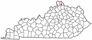
Kenton County is a county located in the northern part of the Commonwealth of Kentucky. As of the 2020 census, the population was 169,064, making it the third most populous county in Kentucky. Its county seats are Covington and Independence. It was, until November 24, 2010, the only county in Kentucky to have two legally recognized county seats. The county was formed in 1840 and is named for Simon Kenton, a frontiersman notable in the early history of the state.

Grant County is a county located in the northern part of the U.S. state of Kentucky. As of the 2020 census, the population was 24,941. Its county seat is Williamstown. The county was formed in 1820 and named for Colonel John Grant, who led a party of settlers in 1779 to establish Grant's Station, in today's Bourbon County, Kentucky. Grant County is included in the Cincinnati-Middletown, OH-KY-IN Metropolitan Statistical Area. Grant County residents voted to allow full alcohol sales in the county by a margin of 56% to 44% in a special election on December 22, 2015. In the 19th century, Grant County had multiple saloons.
Campbell County is a county located in the northern part of the U.S. state of Kentucky. As of the 2020 census, the population was 93,076. Its county seats are Alexandria and Newport. The county was formed on December 17, 1794, from sections of Scott, Harrison, and Mason Counties and was named for Colonel John Campbell (1735–1799), a Revolutionary War soldier and Kentucky legislator. Campbell County, with Boone and Kenton Counties, is part of the Northern Kentucky metro community, and the Cincinnati-Middletown, OH-KY-IN Metropolitan Statistical Area.

Boone County is a county located on the Ohio River in the northernmost part of the U.S. state of Kentucky. As of the 2020 census, the population was 135,968, making it the fourth-most populous county in Kentucky. Its county seat is Burlington. The county was formed in 1798 from a portion of Campbell County. and was named for frontiersman Daniel Boone. Boone County, with Kenton and Campbell Counties, is of the Northern Kentucky metro area, and the Cincinnati-Middletown, OH-KY-IN Metropolitan Statistical Area. It is the location of the Cincinnati/Northern Kentucky International Airport, which serves Cincinnati and the tri-state area.

Greenup is a home rule-class city located at the confluence of the Little Sandy River with the Ohio River in Greenup County, Kentucky, United States. The population was 1,188 at the 2010 census. Greenup is one of three county seats in the Commonwealth of Kentucky to share its name with its county; the other two being Harlan and Henderson.
Fairdale is a former census-designated place in southern Jefferson County, Kentucky, United States. The population was 7,658 at the 2000 census. In 2003, the area was annexed to the city of Louisville due to a merger between the city and Jefferson County's unincorporated community. Fairdale is now a neighborhood within the city limits of Louisville. The ZIP Code for Fairdale is 40118.
It is within the boundaries of the Fairdale Fire Protection District which serves Fairdale and surrounding areas including the large Jefferson Memorial Forest and historic South Park Country Club, the oldest country club in the state of Kentucky.

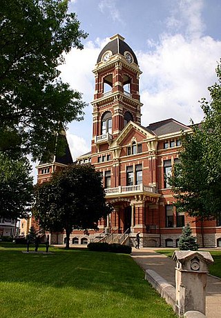
Covington is a home rule-class city in Kenton County, Kentucky, United States. Located at the confluence of the Ohio and Licking rivers, it lies south of Cincinnati, Ohio, across the Ohio and west of Newport, Kentucky, across the Licking. It had a population of 40,691 at the 2020 census, making it the largest city in Northern Kentucky and the fifth-most populous city in the state. A part of the Cincinnati metropolitan area, it is one of Kenton County's two seats, along with Independence.

Erlanger is a home rule-class city in Kenton County, Kentucky, United States. It had a 2010 census population of 18,368. Erlanger is part of the Cincinnati-Middletown, OH-KY-IN Metropolitan Statistical Area.
Independence is a home rule-class city in Kenton County, Kentucky, in the United States. It is one of its county's two seats of government. The population was 24,757 at the time of the 2010 U.S. census, up from 14,982 at the 2000 census. It is the third largest city in Northern Kentucky after Covington and Florence.

Kenton Vale is a home rule-class city in Kenton County, Kentucky, in the United States. The population was 110 at the 2010 U.S. census.
Visalia was a city in Kenton County, Kentucky, United States. The population was 111 at the 2000 census. The city government was dissolved in November 2006.

Maysville is a home rule-class city in Mason County, Kentucky, United States, and is the seat of Mason County. The population was 8,873 as of the 2020 census. Maysville is on the Ohio River, 66 miles (106 km) northeast of Lexington. It is the principal city of the Maysville Micropolitan Statistical Area, which comprises Mason County. Two bridges cross the Ohio from Maysville to Aberdeen, Ohio: the Simon Kenton Memorial Bridge built in 1931 and the William H. Harsha Bridge built in 2001.

Kentucky's 4th congressional district is a congressional district in the U.S. state of Kentucky. Located in the northeastern portion of the state, it is a long district that follows the Ohio River. However, the district is dominated by its far western portion, comprising the eastern suburbs of Louisville and Northern Kentucky, the Kentucky side of the Cincinnati area.
Latonia is a former city, now neighborhood of Covington in Kenton County, Kentucky, United States.
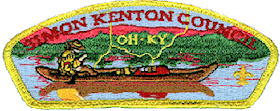
The Simon Kenton Council (#441) is a Boy Scouts of America council created in 1994 that serves members of the Cub Scouts, Scouts BSA, Venturing, Exploring and in-school programs in central and southern Ohio, and northern Kentucky. The council is divided into five districts with headquarters in Columbus, Ohio. Simon Kenton Council is named for frontiersman Simon Kenton.

The Kenton County Public Library is a library system serving the residents of Kenton County, Kentucky. The library ranked first in Kentucky in Hennen's American Public Library Ratings 2008.
Mother of God Cemetery, Covington, Kentucky, was first located at 26th Street and Madison Avenue in 1849, and was moved to its current location at 2701 Latonia Avenue in 1887. The old cemetery was also known as the Buena Vista Cemetery or St Joseph Cemetery. Some of the graves were moved from the old cemetery, while others were not.
Scott High School is located at 5400 Old Taylor Mill Road in Taylor Mill, Kentucky. The school's athletic teams are known as the "Eagles". The school is one of three high schools operated by the Kenton County School District. It opened for classes in 1978, where it originally featured an open classroom design. This school is widely known for its prestigiousness, having a 5% acceptance rate. Scott High School sits on a 78-acre (320,000 m2) campus that is shared with Woodland Middle School which was built in 1988. The campus includes a football field, softball and two baseball fields, lighted soccer field, tennis courts and is the only high school in Kenton County with an indoor pool. Scott now has a new wing addition with additional rooms, bigger lockers, smart classrooms, etc. that finished in the summer of 2014. Scott has approximately 1100 students and 65 faculty members. As of the 2022–2023 school year, Alan Yanke is the principal. Starting in 2012, the school has undergone massive renovation and construction including multiple new wings, which added a new cafeteria and library, as well as smart classrooms. The most recent addition was completed before the start of the 2019–2020 school year.

Kenton County Golf Course is located at 3908 Richardson Road, Independence, KY 41051 and offers a 54-hole facility. All three of the courses offer low handicappers, as well as the average golfer challenging and fun layouts. The Pioneer is the shortest of the courses playing to a par 71. As the name indicates, it was the first course built at the complex in 1968. The Pioneer course is 5,880 yards with a rating of 68.4, a slope of 115. It is like most mid-western courses, slightly sloping on the front nine with increasing slopes on the back. Easily the most walkable course at the complex. Power carts are optional and they may be taken across the fairway at 90 degrees. The Willows, designed by Dr. Michael Hurdzan, offers golfers a scenic and challenging test of tree-lined fairways and undulating greens. The Willows course plays to 6,697 yards from the championship tees, rated 9th in Kentucky. Par 72, and the course rating is 72.6 and the slope is 137. The Willows is a real challenge of golf, for any level player. Power carts are optional, and are permitted to cross at 90 degrees. Fox Run, another masterpiece by renowned architect Arthur Hills, this distinctively different golf course provides a wonderful blend of architectural style from hole to hole. Here you will find links-type holes which somewhat resemble that of a Scottish golf course. There is a sampling of Carolina-type holes with drastic changes in elevation from tee to green. Finally, there is a balance of more traditional mid-western style golf holes: all of which gracefully blend with the natural terrain and surrounding environment. The absence of housing and condo developments within the course allows the golfer to truly experience nature in its spectacular beauty. This course is consistently rated one of the most challenging public courses in the State of Kentucky. Kenton County Golf Course also has a driving range and a clubhouse with a pro-shop, a bar, and a wide variety of food.
