
The Blacksburg-Christiansburg Metropolitan Statistical Area, formerly the Blacksburg-Christiansburg-Radford Metropolitan Statistical Area, is a Metropolitan Statistical Area (MSA) as defined by the United States Office of Management and Budget (OMB) located in the New River Valley of Southwest Virginia. As of the 2020 census, the MSA had a population of 181,863.

The Kingsport–Bristol–Bristol metropolitan area is a metropolitan statistical area (MSA) in Northeast Tennessee and Southwest Virginia, United States, as defined by the Office of Management and Budget (OMB). It was formed in December 2003 by the merger of the Bristol, VA MSA and Kingsport–Bristol, TN–VA MSA.

The Lynchburg Metropolitan Statistical Area is a United States Metropolitan Statistical Area (MSA) in the state of Virginia, as defined by the Office of Management and Budget (OMB) as of June 2003. As of the 2000 census, the MSA had a population of 228,616. In 2009 this was estimated to have risen to 247,447; as of 2016, the Lynchburg MSA was estimated to have a population of 260,320, making it the fifth-largest metro area in the state.
The Charleston Metropolitan Statistical Area, as defined by the United States Census Bureau, is an area consisting of three counties in West Virginia, anchored by the city of Charleston. It is the largest metropolitan area entirely within the state of West Virginia. While the Huntington Metro Area is more populous, it spans three states, and the core county of the Charleston area, Kanawha County, is more populous than the West Virginia portion of the Huntington area.

The Lubbock–Plainview Combined Statistical Area consists of the Lubbock Metropolitan Area and the Plainview Micropolitan Area and comprises eight counties: in the South Plains region of west Texas. The Levelland Micropolitan Statistical Area was a separate statistical area within the CSA until 2023 when it was added to the Lubbock MSA. In the 2010 census, the CSA had a population of 350,013, though a July 1, 2019 estimate placed the population at 381,664. The CSA's principal city is Lubbock.

The Parkersburg–Vienna metropolitan area, officially the Parkersburg–Vienna, WV Metropolitan Statistical Area as defined by the United States Census Bureau, is an area consisting of two counties in West Virginia, anchored by the cities of Parkersburg and Vienna. As of the 2020 census, the MSA had a population of 89,490. Prior to the 2020 census, the metro area included the city of Marietta, Ohio and Washington County, which has since been redefined as its own micropolitan area. They now form the Parkersburg–Marietta–Vienna, WV–OH Combined Statistical Area.
The Salisbury, MD-DE Metropolitan Statistical Area is a United States Census Bureau-designated metropolitan area centered in and around Salisbury, Maryland, including four counties: Somerset, Wicomico, and Worcester in Maryland; and Sussex in Delaware.

The Rockford Metropolitan Statistical Area, as defined by the United States Census Bureau, is an area consisting of four counties in north-central Illinois, anchored by the city of Rockford. As of the 2010 census, the MSA had a population of 349,431. The Rockford MSA abuts the southern portions of the Janesville-Beloit MSA and the Chicago MSA. It forms the main part of the larger Rockford–Freeport–Rochelle Combined Statistical Area.

The city of Portland, Maine, is the hub city of a metropolitan area in southern Maine. The region is commonly known as Greater Portland or the Portland metropolitan area. For statistical purposes, the U.S. federal government defines three different representations of the Portland metropolitan area. The Portland–South Portland, Maine, metropolitan statistical area is a region consisting of three counties in Maine, anchored by the city of Portland and the smaller city of South Portland. As of the 2020 census, the MSA had a population of 551,740. A larger combined statistical area (CSA), the Portland–Lewiston–South Portland combined statistical area, is defined as the combination of this metropolitan statistical area (MSA) with the adjacent Lewiston–Auburn MSA. The CSA comprises four counties in southern Maine. The Portland–South Portland metropolitan New England city and town area is defined on the basis of cities and towns rather than entire counties. It consists of most of Cumberland and York counties plus the town of Durham in Androscoggin County. The Greater Portland area has emerged as an important center for the creative economy, which is also bringing gentrification.

The Montgomery, Alabama Metropolitan Statistical Area is a metropolitan area in central Alabama. As of 2020, the MSA had a population of 386,047, ranking it 142nd among United States Metropolitan Statistical Areas. That number is up +3.07% from the 2010 census number of 374,536. In September of 2018 the OMB formed the Montgomery-Selma-Alexander City CSA. It's made up of the 4 county Montgomery MSA and the Selma, AL and Alexander City, AL micropolitan areas. The 7 county CSA has a population of 522,873 as of the 2020 census.

The Wichita, Kansas Metropolitan Statistical Area, as defined by the United States Office of Management and Budget, is an area consisting of four counties in south central Kansas, its only principal city is Wichita and its only central county is Sedgwick County. As of the 2013 American Community Survey, the MSA had a population of 637,989.

The Columbus metropolitan area, officially the Columbus metropolitan statistical area, and colloquially known as the Chattahoochee Valley, is a metropolitan statistical area consisting of six counties in the U.S. state of Georgia and one county in Alabama, anchored by the city of Columbus.

The South Bend–Mishawaka Metropolitan Statistical Area, sometimes referred to as Michiana, as defined by the United States Census Bureau, is an area consisting of two counties – one in northern Indiana and one in southwest Michigan (Cass), anchored by the cities of South Bend and Mishawaka in Indiana. As of the 2010 census, the MSA had a population of 319,224.

The Bloomsburg–Berwick Metropolitan Statistical Area (MSA), as defined by the United States Census Bureau, is an area consisting of two counties in Pennsylvania, anchored by the town of Bloomsburg and the borough of Berwick. As of the 2010 census, the MSA had a population of 85,562.

The Reno–Sparks Metropolitan Statistical Area, as defined by the United States Census Bureau, is an area consisting of two counties in Western Nevada, anchored by the cities of Reno and Sparks. As of the 2020 census, the MSA had a population of 490,596.

The Madison, Wisconsin, metropolitan area, also known as Greater Madison, is the metropolitan area surrounding the city of Madison, Wisconsin. Madison is the state capital of Wisconsin and is Wisconsin's second largest city, and the metropolitan area is also the state's second largest which the Madison MSA borders to its east.

The Macon metropolitan area is a metropolitan statistical area consisting of five counties in Central Georgia, anchored by the principal city of Macon. At the 2010 U.S. census, the five-county area had a population of 232,293. A July 2017 estimate placed the population at 228,914. In 2022, its estimated population was 235,805.
The Kokomo Metropolitan Statistical Area, as defined by the United States Census Bureau, is an area consisting of Howard County in Indiana. Howard County had a population estimate of 83,831 in 2023. Kokomo is also the principal city of the area known as North Central Indiana, the area around Kokomo with economic ties. The six county area including Cass, Clinton, Fulton, Howard, Miami, and Tipton counties had population of 228,331 people in 2010.

The Grand Rapids metropolitan area is a triangular shaped Metro Triplex, in West Michigan, which fans out westward from the primary hub city of Grand Rapids, Michigan, to the other two metro hubs of Muskegon and Holland. The metropolitan area had an estimated population of 1,059,113 in 2017. The region, noted in particular for its western edge abutting the Lake Michigan shoreline and its beaches, is a popular tourist and vacation destination during the summer. Noted popular metro area beach towns include Grand Haven, Holland, Muskegon, and Saugatuck.
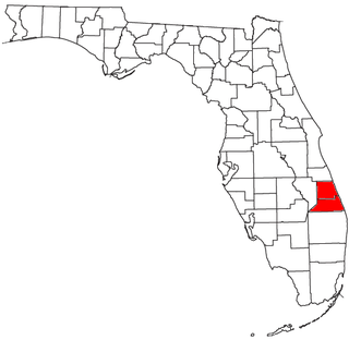
The Port St. Lucie, FL Metropolitan Statistical Area (MSA) includes St. Lucie and Martin counties in the Treasure Coast region of Florida.


