Stockwell, Indiana

Last updated

Stockwell, Indiana
Stockwell Indiana market.png
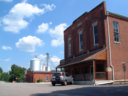
The corner of Orchard and Monroe.
Tippecanoe County Indiana Incorporated and Unincorporated areas Stockwell Highlighted 1873340.svg
Location of Stockwell in Tippecanoe County, Indiana.
Coordinates: 40°16′50″N86°45′02″W / 40.28056°N 86.75056°W / 40.28056; -86.75056
Country United States
State Indiana
County Tippecanoe County
Township Lauramie Township
Founded1859
Area
[1]
  Total2.47 sq mi (6.40 km2)
  Land2.47 sq mi (6.40 km2)
Elevation
[2]
771 ft (235 m)
Population
 (2020)
  Total494
  Density199.92/sq mi (77.19/km2)
Time zone UTC-5 (Eastern (EST))
  Summer (DST) UTC-4 (EDT)
ZIP code
47983
Area code 765
GNIS feature ID2583472 [2]

Stockwell, originally named Lauramie, is a census-designated place in Lauramie Township, Tippecanoe County, in the U.S. state of Indiana. [2] It was once a stop along the Indianapolis, Cincinnati and Lafayette Railroad, but the rail line has since been removed.

Contents

The community is part of the Lafayette, Indiana Metropolitan Statistical Area.

History

An old variant name of the community was called Bakers Corner. [3]

A post office was established under the name Bakers Corners in 1853, and was renamed to Stockwell in 1859. It is still currently in operation. [4]

Geography

Stockwell is on a bend in Lauramie Creek in Lauramie Township, less than two miles west of U.S. Route 52. Stockwell had a population of 545 at the 2010 census.

Demographics

Historical population
CensusPop.Note
2010 545
2020 494−9.4%
U.S. Decennial Census [5]

Related Research Articles

<span class="mw-page-title-main">Tippecanoe County, Indiana</span> County in Indiana, United States

Tippecanoe County is located in the west-central portion of the U.S. state of Indiana about 22 miles east of the Illinois state line and less than 50 miles from the Chicago and the Indianapolis metro areas. As of the 2020 census, the population was 186,251. The county seat and largest city is Lafayette. It was created in 1826 from Wabash County portion of New Purchase and unorganized territory.

<span class="mw-page-title-main">Lafayette, Indiana</span> City in Indiana, US

Lafayette is a city in and is the county seat of Tippecanoe County, Indiana, United States, located 63 miles (101 km) northwest of Indianapolis and 125 miles (201 km) southeast of Chicago. West Lafayette, on the other side of the Wabash River, is home to Purdue University, which contributes significantly to both communities. Together, Lafayette and West Lafayette form the core of the Lafayette metropolitan area, which had a population of 224,709 in the 2021 US Census Bureau estimates.

<span class="mw-page-title-main">Romney, Indiana</span> Unincorporated community and Census-designated place in Indiana, United States

Romney is an unincorporated community in Randolph Township, Tippecanoe County, in the U.S. state of Indiana.

<span class="mw-page-title-main">Pittsburg, Indiana</span> Unincorporated community in Indiana, United States

Pittsburg is an unincorporated community in Tippecanoe Township, Carroll County, Indiana. It is part of the Lafayette, Indiana Metropolitan Statistical Area.

<span class="mw-page-title-main">Americus, Indiana</span> Census-designated place in Indiana, United States

Americus is a small census-designated place in Washington Township, Tippecanoe County, in the U.S. state of Indiana.

<span class="mw-page-title-main">Buck Creek, Indiana</span> Census-designated place in Indiana, United States

Buck Creek is an unincorporated census-designated place in Washington Township, Tippecanoe County, in the U.S. state of Indiana.

<span class="mw-page-title-main">Colburn, Indiana</span> Census-designated place in Indiana, United States

Colburn is a small unincorporated census-designated place in northeastern Washington Township, Tippecanoe County, in the U.S. state of Indiana.

<span class="mw-page-title-main">Montmorenci, Indiana</span> Census-designated place in Indiana, United States

Montmorenci is an unincorporated census-designated place in Shelby Township, Tippecanoe County, Indiana. Older maps sometimes spell the name Montmorency or Montmorencie.

<span class="mw-page-title-main">Monroe, Tippecanoe County, Indiana</span> Unincorporated community in Indiana, United States

Monroe is a small unincorporated community in Lauramie Township, Tippecanoe County, in the U.S. state of Indiana. The community is part of the Lafayette, Indiana Metropolitan Statistical Area.

<span class="mw-page-title-main">Odell, Indiana</span> Unincorporated community in Indiana, United States

Odell is a small unincorporated community in Jackson Township, Tippecanoe County, in the U.S. state of Indiana.

<span class="mw-page-title-main">West Point, Indiana</span> Census-designated place in Indiana, United States

West Point is an unincorporated community and census-designated place in Wayne Township, Tippecanoe County, in the U.S. state of Indiana. The population was 594 at the 2010 census.

<span class="mw-page-title-main">Perry Township, Clinton County, Indiana</span> Township in Indiana, United States

Perry Township is one of fourteen townships in Clinton County, Indiana. As of the 2010 census, its population was 1,459 and it contained 606 housing units. The township was named for Oliver Hazard Perry, an American naval officer in the War of 1812.

<span class="mw-page-title-main">Washington Township, Clinton County, Indiana</span> Township in Indiana, United States

Washington Township is one of fourteen townships in Clinton County, Indiana, United States. As of the 2010 census, its population was 1,098 and it contained 465 housing units. The township was named for President George Washington.

<span class="mw-page-title-main">Lauramie Township, Tippecanoe County, Indiana</span> Township in Indiana, United States

Lauramie Township is one of thirteen townships in Tippecanoe County, Indiana, United States. As of the 2010 census, its population was 2,596 and it contained 1,021 housing units.

<span class="mw-page-title-main">Randolph Township, Tippecanoe County, Indiana</span> Township in Indiana, United States

Randolph Township is one of thirteen townships in Tippecanoe County, Indiana, United States. As of the 2010 census, its population was 931 and it contained 352 housing units. As for 2018, the population is estimated to be 1,084.

<span class="mw-page-title-main">Sheffield Township, Tippecanoe County, Indiana</span> Township in Indiana, United States

Sheffield Township is one of thirteen townships in Tippecanoe County, Indiana, United States. As of the 2010 census, its population was 3,865 and it contained 1,454 housing units.

<span class="mw-page-title-main">Wea Township, Tippecanoe County, Indiana</span> Township in Indiana, United States

Wea Township is one of thirteen townships in Tippecanoe County, Indiana, United States. As of the 2010 census, its population was 31,660 and it contained 13,022 housing units.

Tippecanoe is an unincorporated community and census-designated place (CDP) in Tippecanoe Township, Marshall County, Indiana, United States.

<span class="mw-page-title-main">Concord, Tippecanoe County, Indiana</span> Unincorporated community in Indiana, United States

Concord is a small unincorporated community in Lauramie Township, Tippecanoe County, Indiana, located just west of Stockwell.

<span class="mw-page-title-main">Gladens Corner, Indiana</span> Unincorporated community in Indiana, United States

Gladens Corner is an unincorporated community in Lauramie Township, Tippecanoe County, in the U.S. state of Indiana.

References

  1. "2020 U.S. Gazetteer Files". United States Census Bureau. Retrieved March 16, 2022.
  2. 1 2 3 U.S. Geological Survey Geographic Names Information System: Stockwell, Indiana
  3. "USGS detail on Stockwell - Variant Citation" . Retrieved July 25, 2016.
  4. "Tippecanoe County". Jim Forte Postal History. Retrieved July 25, 2016.
  5. "Census of Population and Housing". Census.gov. Retrieved June 4, 2016.