
The Tippecanoe River is a gentle, 182-mile-long (293 km) river in the Central Corn Belt Plains ecoregion in northern Indiana. It flows from Crooked Lake in Noble County to the Wabash River near what is now Battle Ground, about 12 miles (19 km) northeast of Lafayette. The name "Tippecanoe" was derived from a Miami-Illinois word for buffalo fish, reconstructed as */kiteepihkwana/ or as kiteepihkwana siipiiwi.

Romney is an unincorporated community in Randolph Township, Tippecanoe County, in the U.S. state of Indiana.

Heath was a small town, now extinct, in Perry Township, Tippecanoe County, in the U.S. state of Indiana.

Stockwell, originally named Lauramie, is a census-designated place in Lauramie Township, Tippecanoe County, in the U.S. state of Indiana. It was once a stop along the Indianapolis, Cincinnati and Lafayette Railroad, but the rail line has since been removed.
South Raub is a small unincorporated community on the border of Randolph and Wea Townships in Tippecanoe County, Indiana.
Taylor is a small unincorporated community in Union Township, Tippecanoe County, in the U.S. state of Indiana.

West Point is an unincorporated community and census-designated place in Wayne Township, Tippecanoe County, in the U.S. state of Indiana. The population was 594 at the 2010 census.

Deer Creek Township is one of fourteen townships in Carroll County, Indiana. As of the 2020 census, its population was 4,566 and it contained 1,975 housing units.

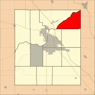
Fairfield Township is one of thirteen townships in Tippecanoe County, Indiana. As of the 2010 census, its population was 51,113 and it contained 24,527 housing units.

Jackson Township is one of thirteen townships in Tippecanoe County, Indiana, United States. As of the 2010 census, its population was 499 and it contained 185 housing units.

Lauramie Township is one of thirteen townships in Tippecanoe County, Indiana, United States. As of the 2010 census, its population was 2,596 and it contained 1,021 housing units.

Perry Township is one of thirteen townships in Tippecanoe County, Indiana, United States. As of the 2010 census, its population was 7,161 and it contained 2,782 housing units.

Randolph Township is one of thirteen townships in Tippecanoe County, Indiana, United States. As of the 2010 census, its population was 931 and it contained 352 housing units. As for 2018, the population is estimated to be 1,084.

Sheffield Township is one of thirteen townships in Tippecanoe County, Indiana, United States. As of the 2010 census, its population was 3,865 and it contained 1,454 housing units.

Tippecanoe Township is one of thirteen townships in Tippecanoe County, Indiana, United States. As of the 2010 census, its population was 7,702 and it contained 3,085 housing units.

Union Township is one of thirteen townships in Tippecanoe County, Indiana, United States. As of the 2010 census, its population was 1,610 and it contained 675 housing units.
Washington Township is one of thirteen townships in Tippecanoe County, Indiana, United States. As of the 2010 census, its population was 2,432 and it contained 1,002 housing units.

Wea Township is one of thirteen townships in Tippecanoe County, Indiana, United States. As of the 2010 census, its population was 31,660 and it contained 13,022 housing units.

Tippecanoe Township is one of ten townships in Marshall County, Indiana, United States. As of the 2020 census, its population was 1,322 and it contained 529 housing units.

Lee is an unincorporated community in Monon Township, White County, in the U.S. state of Indiana.


