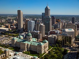
Indianapolis, colloquially known as Indy, is the capital and most populous city of the U.S. state of Indiana and the seat of Marion County. Located in Central Indiana, the city lies along the White River's West Fork near its confluence with Fall Creek.

Tippecanoe County is located in the west-central portion of the U.S. state of Indiana about 22 miles east of the Illinois state line and less than 50 miles from the Chicago and the Indianapolis metro areas. As of the 2020 census, the population was 186,251. The county seat and largest city is Lafayette. It was created in 1826 from Wabash County portion of New Purchase and unorganized territory.

Gibson County is a county in the southwestern part of the U.S. state of Indiana. As of the 2020 United States Census, the population was 33,011. The county seat is Princeton.
Fort Branch is the largest town and 2nd largest community in Gibson County, Indiana after Princeton. The population was 2,965 at the 2020 census. It is part of the Evansville, Indiana, Metropolitan Area.

Owensville is the third largest town and the smallest of the five larger communities in Gibson County, Indiana, United States. The population was 1,338 in 2020.

Princeton is the largest city in and the county seat of Patoka Township, Gibson County, Indiana, United States. The population was 8,301 at the 2020 United States Census, and it is part of the greater Evansville, Indiana, Metropolitan Area.

Highland is a town in Lake County, Indiana, United States. The population was 23,984 at the 2020 census. The town was incorporated on April 4, 1910. It is a part of the Chicago metropolitan area and North Township, and is surrounded by Hammond to the north, Munster to the west, Schererville to the south and Griffith to the east.
Greencastle is a city in Greencastle Township, Putnam County, Indiana, United States, and the county seat of Putnam County. It is located near Interstate 70 approximately halfway between Terre Haute and Indianapolis in the west-central portion of the state. The city is the home of DePauw University. The population was 9,820 at the 2020 census.
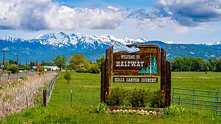
Halfway is a city in Baker County, Oregon, United States. The city took its name from the location of its post office, on the Alexander Stalker ranch, halfway between Pine and Jim Town. The population was 351 at the 2020 census.
Mount Meridian is an unincorporated community in Marion Township, Putnam County, in the U.S. state of Indiana. Primarily on US 40, it is approximately 34 miles (55 km) west of Indianapolis. It is called Mount Meridian due to its being the highest place in the county and surrounding areas.

State Road 62 (SR 62) in the U.S. state of Indiana is an east–west route that travels 204 miles (328 km) from the Illinois state line in the southwest corner of Indiana to the Louisville, Kentucky area, then northeast toward the Cincinnati, Ohio area.
Talma is an unincorporated community in Newcastle Township, Fulton County, Indiana.
Belmont is an unincorporated community in Washington Township, Brown County, in the U.S. state of Indiana.

Shelby Township is one of thirteen townships in Tippecanoe County, Indiana, United States. As of the 2010 census, its population was 2,352 and it contained 920 housing units.

Rugby is an unincorporated community in Haw Creek Township, Bartholomew County, in the U.S. state of Indiana.
Snake Run is an unincorporated community stretched along Indiana 168 nearly halfway between Fort Branch and Mackey in Gibson County, Indiana, United States. It is in both Barton and Union Townships. It is named after the creek which runs through the central part of the community. Saint Bernards Catholic Church is the heart of the area.

McCutchanville is an unincorporated community in Center Township, Vanderburgh County, in the U.S. state of Indiana. McCutchanville was established in 1845 and is named for Samuel McCutchan, a Scottish/Irish immigrant who was the first postmaster for the area.
Denmark is an unincorporated community in the southwest portion of Marion Township, Owen County, in the U.S. state of Indiana. It lies near the intersection of County Road 1400 West and County Road 150 South, which is a community about fifteen miles west of the city of Spencer, the county seat of Owen County. Its elevation is 722 feet, and it is located at 39°16′11″N87°1′33″W.
Smithville is an unincorporated community in the northwest corner of Marion Township, Owen County, in the U.S. state of Indiana. It lies near the intersection of County Road 200 North and County Road 1400 West, which is a community about fifteen miles west of the city of Spencer, the county seat. Its elevation is 591 feet, and it is located at 39°19′15″N87°1′33″W.
Hickory Corner is an unincorporated community in the northwest corner of Marion Township, Owen County, in the U.S. state of Indiana. It lies near the intersection of County Road 1500 West and Orman Road, which is a community about twenty miles west of the city of Spencer, the county seat. Its elevation is 643 feet, and it is located at 39°18′18″N87°2′40″W.


