Wyandot, Indiana

Last updated
Wyandot, Indiana
Map of Indiana highlighting Tippecanoe County.svg
Tippecanoe County's location in Indiana
Locator map of Tippecanoe County, Indiana.svg
Red pog.svg
Wyandot
Location in Tippecanoe County
Coordinates: 40°20′43″N86°44′58″W / 40.34528°N 86.74944°W / 40.34528; -86.74944 Coordinates: 40°20′43″N86°44′58″W / 40.34528°N 86.74944°W / 40.34528; -86.74944
Country United States
State Indiana
County Tippecanoe
Township Sheffield
Elevation
[1]
659 ft (201 m)
Time zone UTC-5 (Eastern (EST))
  Summer (DST) UTC-4 (EDT)
ZIP code
47905
Area code(s) 765
GNIS feature ID 446346

Wyandot (sometimes shown as Wyandotte [2] ) was a small town, now extinct, in Sheffield Township, Tippecanoe County, in the U.S. state of Indiana.

Contents

History

The Indian town of Wyandot in Sheffield Township was located in the ravine that is crossed by Dayton Road and runs past Wyandotte Cemetery into the Wildcat Creek. It is thought that the Indians moved their village down to the creek's banks in the summer and retreated up the ravine in the winter. They lived in log houses and operated a trading post. When the White Settlers arrived, the Indians living there were probably neither Miami or Wyandott, but instead were most likely Potawatomi.

In 1849, a post office was established in Wyandot, and remained in operation until it was discontinued in 1872. [3]

Geography

Wyandot is located at 40°20′43″N86°44′58″W / 40.34528°N 86.74944°W / 40.34528; -86.74944 with an elevation of 659 feet.

A few buildings in the community still exist, and it is still cited by the USGS. [4]

Richardville Indian Reserve

The Richardville Indian Reserve was located in Sheffield Township and was one of six Reserves located in Tippecanoe County. It was owned by Jean-Baptiste Richardville and in 1818 the land surrounding the village was divided into five sections for his five children.

See also

Related Research Articles

Colburn, Indiana Census-designated place in Indiana, United States

Colburn is a small unincorporated census-designated place in northeastern Washington Township, Tippecanoe County, in the U.S. state of Indiana.

Heath, Indiana Ghost town in Indiana, United States

Heath was a small town, now extinct, in Perry Township, Tippecanoe County, in the U.S. state of Indiana.

Monroe, Tippecanoe County, Indiana Unincorporated community in Indiana, United States

Monroe is a small unincorporated community in Lauramie Township, Tippecanoe County, in the U.S. state of Indiana. The community is part of the Lafayette, Indiana Metropolitan Statistical Area.

Odell, Indiana Unincorporated community in Indiana, United States

Odell is a small unincorporated community in Jackson Township, Tippecanoe County, in the U.S. state of Indiana.

Stockwell, Indiana Census-designated place in Indiana, United States

Stockwell, originally named Lauramie, is a census-designated place in Lauramie Township, Tippecanoe County, in the U.S. state of Indiana. It was once a stop along the Indianapolis, Cincinnati and Lafayette Railroad, but the rail line has since been removed.

Monitor, Indiana Unincorporated community in Indiana, United States

Monitor is a small unincorporated community in Perry Township, Tippecanoe County, in the U.S. state of Indiana, now almost virtually extinct.

South Raub, Indiana Unincorporated community in Indiana, United States

South Raub is a small unincorporated community on the border of Randolph and Wea Townships in Tippecanoe County, Indiana.

Taylor, Indiana Unincorporated community in Indiana, United States

Taylor is a small unincorporated community in Union Township, Tippecanoe County, in the U.S. state of Indiana.

West Point, Indiana Census-designated place in Indiana, United States

West Point is an unincorporated community and census-designated place in Wayne Township, Tippecanoe County, in the U.S. state of Indiana. The population was 594 at the 2010 census.

Corwin, Tippecanoe County, Indiana Ghost town in Indiana, United States

Corwin was a small town, now extinct, in Randolph Township, Tippecanoe County, in the U.S. state of Indiana.

Fairfield Township, Tippecanoe County, Indiana Township in Indiana, United States

Fairfield Township is one of thirteen townships in Tippecanoe County, Indiana. As of the 2010 census, its population was 51,113 and it contained 24,527 housing units.

Lauramie Township, Tippecanoe County, Indiana Township in Indiana, United States

Lauramie Township is one of thirteen townships in Tippecanoe County, Indiana, United States. As of the 2010 census, its population was 2,596 and it contained 1,021 housing units.

Sheffield Township, Tippecanoe County, Indiana Township in Indiana, United States

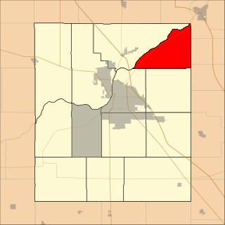
Sheffield Township is one of thirteen townships in Tippecanoe County, Indiana, United States. As of the 2010 census, its population was 3,865 and it contained 1,454 housing units.

Tippecanoe Township, Tippecanoe County, Indiana Township in Indiana, United States

Tippecanoe Township is one of thirteen townships in Tippecanoe County, Indiana, United States. As of the 2010 census, its population was 7,702 and it contained 3,085 housing units.

Washington Township, Tippecanoe County, Indiana Township in Indiana, United States

Washington Township is one of thirteen townships in Tippecanoe County, Indiana, United States. As of the 2010 census, its population was 2,432 and it contained 1,002 housing units.

Cairo, Indiana Unincorporated community in Indiana, United States

Cairo is an unincorporated community in Tippecanoe Township, Tippecanoe County, in the U.S. state of Indiana.

Octagon, Indiana Unincorporated community in Indiana, United States

Octagon is an unincorporated community in Wabash Township, Tippecanoe County, in the U.S. state of Indiana.

Delp, Indiana Unincorporated community in Indiana, United States

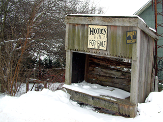
Delp is an unincorporated community in Washington Township, Tippecanoe County, in the U.S. state of Indiana.

Birmingham, Tippecanoe County, Indiana Unincorporated community in Indiana, United States

Birmingham is an unincorporated community in Fairfield Township, Tippecanoe County, in the U.S. state of Indiana.

References

  1. "US Board on Geographic Names". United States Geological Survey. October 25, 2007. Retrieved 2016-07-25.
  2. "Ghost Towns of Tippecanoe County" . Retrieved 2016-07-26.
  3. "Tippecanoe County". Jim Forte Postal History. Retrieved July 25, 2016.
  4. "Wyandot, Indiana". Geographic Names Information System . United States Geological Survey . Retrieved 2016-07-25.