
Tippecanoe County is located in the west-central portion of the U.S. state of Indiana about 22 miles east of the Illinois state line and less than 50 miles from the Chicago and the Indianapolis metro areas. As of the 2020 census, the population was 186,251. The county seat and largest city is Lafayette. It was created in 1826 from Wabash County portion of New Purchase and unorganized territory.

Lafayette is a city in and is the county seat of Tippecanoe County, Indiana, United States, located 63 miles (101 km) northwest of Indianapolis and 125 miles (201 km) southeast of Chicago. West Lafayette, on the other side of the Wabash River, is home to Purdue University, which contributes significantly to both communities. Together, Lafayette and West Lafayette form the core of the Lafayette metropolitan area, which had a population of 224,709 in the 2021 US Census Bureau estimates.

West Lafayette is a city in Wabash Township, Tippecanoe County, Indiana, United States, approximately 65 miles (105 km) northwest of the state capital of Indianapolis and 113 miles (182 km) southeast of Chicago. West Lafayette is directly across the Wabash River from its sister city, Lafayette. As of the 2020 census, its population was 44,595. A college town, it is the most densely populated city in Indiana and is home to Purdue University.

Romney is an unincorporated community in Randolph Township, Tippecanoe County, in the U.S. state of Indiana.

Indiana's 4th congressional district is a congressional district in the U.S. state of Indiana. From 2003 to 2013 the district was based primarily in the central part of the state, and consisted of all of Boone, Clinton, Hendricks, Morgan, Lawrence, Montgomery, and Tippecanoe counties and parts of Fountain, Johnson, Marion, Monroe, and White counties. The district surrounded Indianapolis including the suburban area of Greenwood and encompassed the more exurban areas of Crawfordsville and Bedford, as well as the college town of Lafayette-West Lafayette, containing Purdue University.

Pittsburg is an unincorporated community in Tippecanoe Township, Carroll County, Indiana. It is part of the Lafayette, Indiana Metropolitan Statistical Area.

Wabash Township is one of thirteen townships in Tippecanoe County, Indiana, United States. As of the 2010 census, its population was 59,279 and it contained 21,448 housing units making it the most populous township in Tippecanoe County.

West Lafayette Junior-Senior High School is the only high school within the West Lafayette city limits, and is administered by the West Lafayette Community School Corporation.

Colburn is a small unincorporated census-designated place in northeastern Washington Township, Tippecanoe County, in the U.S. state of Indiana.

Odell is a small unincorporated community in Jackson Township, Tippecanoe County, in the U.S. state of Indiana.

Stockwell, originally named Lauramie, is a census-designated place in Lauramie Township, Tippecanoe County, in the U.S. state of Indiana. It was once a stop along the Indianapolis, Cincinnati and Lafayette Railroad, but the rail line has since been removed.

Interstate 65 (I-65) in the US state of Indiana traverses from the south-southeastern Falls City area bordering Louisville, Kentucky, through the centrally located capital city of Indianapolis, to the northwestern Calumet Region of the Hoosier State which is part of the Chicago metropolitan area. The Indiana portion of I-65 begins in Jeffersonville after crossing the Ohio River and travels mainly north, passing just west of Columbus prior to reaching the Indianapolis metro area. Upon reaching Indianapolis, the route alignment of I-65 begins to run more to the northwest and subsequently passes Lafayette on that city's east and north sides. Northwest of there, in west-central Jasper County, the route again curves more northward as it approaches the Calumet Region. Shortly after passing a major junction with I-80 and I-94, I-65 reaches its northern national terminus in Gary at I-90 which is carried on the Indiana East–West Toll Road. I-65 covers 261.27 miles (420.47 km) in the state of Indiana. This is one of the principal Interstate Highways that cross the state, and, more specifically, intersect at the city of Indianapolis, that has given the state the nickname of "Crossroads of America".

West Point is an unincorporated community and census-designated place in Wayne Township, Tippecanoe County, in the U.S. state of Indiana. The population was 594 at the 2010 census.

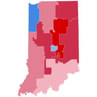
The 2008 congressional elections in Indiana were held on November 4, 2008 to determine who will represent the State of Indiana in the United States House of Representatives. Indiana has nine seats in the House, apportioned according to the 2000 United States census. Representatives are elected for two-year terms; those elected will serve in the 111th Congress from January 3, 2009 until January 3, 2011. The elections coincide with the 2008 U.S. presidential election.
The 2004 congressional elections in Indiana were elections for Indiana's delegation to the United States House of Representatives, which occurred along with congressional elections nationwide on November 2, 2004. Republicans held a majority of Indiana's delegation, 6-3, before the elections. The only incumbent to lose re-election was Democrat Baron Hill, who lost to Republican Mike Sodrel in the 9th district.

The 2002 congressional elections in Indiana were elections for Indiana's delegation to the United States House of Representatives, which occurred along with congressional elections nationwide on November 5, 2002. Republicans held a majority of Indiana's delegation, 6-4, before the elections. The districts were redrawn prior to the 2002 elections, reducing the number of districts by 1. Democrat Tim Roemer of the 2nd district retired, leaving the seat vacant. Republicans picked up the 2nd district seat, gaining a 6-3 advantage following the elections.

Lafayette is a census-designated place in the center of Deer Creek Township, Madison County, Ohio, United States. It is located at 39°56′15″N83°24′24″W, along U.S. Route 40, just west of its intersection with U.S. Route 42. The population of Lafayette was 206 at the 2020 census.
Concord is a small unincorporated community in Lauramie Township, Tippecanoe County, Indiana, located just west of Stockwell.
Green Meadows is an unincorporated community in Wabash Township, Tippecanoe County, in the U.S. state of Indiana.
Gladens Corner is an unincorporated community in Lauramie Township, Tippecanoe County, in the U.S. state of Indiana.


