Flora, Indiana

Last updated
Flora, Indiana
Center from Columbia in Flora.jpg
Center Street downtown
Nickname: 
The Garden Spot of Indiana
Carroll County Indiana Incorporated and Unincorporated areas Flora Highlighted 1823692.svg
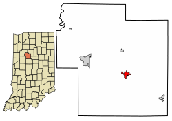
Location of Flora in Carroll County, Indiana.
Coordinates: 40°32′45″N86°31′24″W / 40.54583°N 86.52333°W / 40.54583; -86.52333 Coordinates: 40°32′45″N86°31′24″W / 40.54583°N 86.52333°W / 40.54583; -86.52333
Country United States
State Indiana
County Carroll
Township Monroe
Area
[1]
  Total1.15 sq mi (2.97 km2)
  Land1.15 sq mi (2.97 km2)
  Water0.00 sq mi (0.00 km2)
Elevation
702 ft (214 m)
Population
 (2020)
  Total2,094
  Density1,824.04/sq mi (704.27/km2)
Time zone UTC-5 (EST)
  Summer (DST) UTC-5 (EST)
ZIP code
46929
Area code 574
FIPS code 18-23692 [2]
GNIS feature ID0434609 [3]
Website http://www.townofflora.org/

Flora is a town in Monroe Township, Carroll County, Indiana, United States. The population was 2,036 at the 2010 census. It is part of the Lafayette, Indiana Metropolitan Statistical Area.

Contents

History

A post office was established at Flora in 1873. [4] Flora was named for its founder, John Flora. [5]

Geography

Flora is located at 40°32′45″N86°31′24″W / 40.54583°N 86.52333°W / 40.54583; -86.52333 (40.545819, -86.523367). [6]

According to the 2010 census, Flora has a total area of 1.06 square miles (2.75 km2), all land. [7]

Demographics

Historical population
CensusPop.Note
1880 224
1890 639185.3%
1900 1,20989.2%
1910 1,38614.6%
1920 1,4414.0%
1930 1,4490.6%
1940 1,4681.3%
1950 1,65712.9%
1960 1,7425.1%
1970 1,8777.7%
1980 2,30322.7%
1990 2,179−5.4%
2000 2,2272.2%
2010 2,036−8.6%
2020 2,0942.8%
U.S. Decennial Census [8]
The town's historical marker. Flora, Indiana historical marker.png
The town's historical marker.

2010 census

As of the census [9] of 2010, there were 2,036 people, 858 households, and 549 families living in the town. The population density was 1,920.8 inhabitants per square mile (741.6/km2). There were 969 housing units at an average density of 914.2 per square mile (353.0/km2). The racial makeup of the town was 97.5% White, 0.3% African American, 1.1% from other races, and 0.9% from two or more races. Hispanic or Latino of any race were 2.6% of the population.

There were 858 households, of which 30.5% had children under the age of 18 living with them, 48.7% were married couples living together, 10.8% had a female householder with no husband present, 4.4% had a male householder with no wife present, and 36.0% were non-families. 31.7% of all households were made up of individuals, and 17.8% had someone living alone who was 65 years of age or older. The average household size was 2.37 and the average family size was 2.96.

The median age in the town was 40.4 years. 25.5% of residents were under the age of 18; 7.3% were between the ages of 18 and 24; 22.2% were from 25 to 44; 25.8% were from 45 to 64; and 19.2% were 65 years of age or older. The gender makeup of the town was 46.8% male and 53.2% female.

2000 census

As of the census [2] of 2000, there were 2,227 people, 906 households, and 609 families living in the town. The population density was 2,157.4 inhabitants per square mile (833.0/km2). There were 959 housing units at an average density of 929.0 per square mile (358.7/km2). The racial makeup of the town was 98.16% White, 0.54% African American, 0.04% Native American, 0.04% Pacific Islander, 0.85% from other races, and 0.36% from two or more races. Hispanic or Latino of any race were 2.02% of the population.

There were 906 households, out of which 29.4% had children under the age of 18 living with them, 53.8% were married couples living together, 9.6% had a female householder with no husband present, and 32.7% were non-families. 29.4% of all households were made up of individuals, and 15.6% had someone living alone who was 65 years of age or older. The average household size was 2.36 and the average family size was 2.91.

In the town, the population was spread out, with 23.6% under the age of 18, 8.6% from 18 to 24, 26.4% from 25 to 44, 19.9% from 45 to 64, and 21.5% who were 65 years of age or older. The median age was 39 years. For every 100 females there were 83.9 males. For every 100 females age 18 and over, there were 79.5 males.

The median income for a household in the town was $37,400, and the median income for a family was $43,257. Males had a median income of $35,398 versus $20,281 for females. The per capita income for the town was $18,863. About 4.4% of families and 6.3% of the population were below the poverty line, including 9.9% of those under age 18 and 7.4% of those age 65 or over.

Education

The town has a free lending library, the Flora-Monroe Township Public Library. [10]

Notable people

Related Research Articles

<span class="mw-page-title-main">Malvern, Alabama</span> Town in Alabama, United States

Malvern is a town in Geneva County, Alabama, United States. It is part of the Dothan, Alabama Metropolitan Statistical Area. At the 2010 census the population was 1,448, up from 1,215 in 2000.

<span class="mw-page-title-main">Ashley, Indiana</span> Town in Indiana, United States

Ashley is a town in Indiana located on the border of Smithfield Township, DeKalb County and Steuben Township, Steuben County. The population was 983 at the 2010 census.

<span class="mw-page-title-main">Albany, Indiana</span> Town in Indiana, United States

Albany is a town in Delaware and Randolph counties in the U.S. state of Indiana, along the Mississinewa River. The population was 2,295 at the 2020 census. It is part of the Muncie, IN Metropolitan Statistical Area.

<span class="mw-page-title-main">Wilkinson, Indiana</span> Town in Indiana, United States

Wilkinson is a town in Brown Township, Hancock County, Indiana, United States. The population was 449 at the 2010 census.

<span class="mw-page-title-main">Andrews, Indiana</span> Town in Indiana, United States

Andrews is a town in Dallas Township, Huntington County, Indiana, United States. The population was 1,048 at the 2020 census.

<span class="mw-page-title-main">Bargersville, Indiana</span> Town in Indiana, United States

Bargersville is a town in White River and Union townships, Johnson County, Indiana, United States. The population was 9,560 at the 2020 census.

<span class="mw-page-title-main">New Whiteland, Indiana</span> Town in Indiana, United States

New Whiteland is a town in Pleasant Township, Johnson County, Indiana, United States. The population was 5,550 at the 2020 census.

<span class="mw-page-title-main">Pottawattamie Park, Indiana</span> Town in Indiana, United States

Pottawattamie Park is a town in Michigan Township, LaPorte County, Indiana, United States. The population was 235 at the 2010 census. It is included in the Michigan City, Indiana-La Porte, Indiana Metropolitan Statistical Area.

<span class="mw-page-title-main">Edgewood, Indiana</span> Town in Indiana, United States

Edgewood is a town in Anderson Township, Madison County, Indiana, United States. It is part of the Anderson, Indiana Metropolitan Statistical Area. The population was 1,913 at the 2010 census.

<span class="mw-page-title-main">Ingalls, Indiana</span> Town in Indiana, United States

Ingalls is a town in Green Township, Madison County, Indiana, United States. It is part of the Anderson, Indiana Metropolitan Statistical Area. The population was 2,391 at the 2010 census.

<span class="mw-page-title-main">Paragon, Indiana</span> Town in Indiana, United States

Paragon is a town in Ray Township, Morgan County, in the U.S. state of Indiana. The population was 467 at the 2020 census.

<span class="mw-page-title-main">Clear Lake, Indiana</span> Town in Indiana, United States

Clear Lake is a town located in the northeast corner of Steuben County, Indiana, in Clear Lake Township. As such, is the northeasternmost community in the State of Indiana. The population was 339 at the 2010 census.

<span class="mw-page-title-main">Hudson, Indiana</span> Town in Indiana, United States

Hudson is a town in Salem and Steuben townships, Steuben County, in the U.S. state of Indiana. The population was 518 at the 2010 census.

<span class="mw-page-title-main">Whitneyville, Maine</span> Town in the state of Maine, United States

Whitneyville is a town in Washington County, Maine, United States. The town was named after Colonel Joseph Whitney, a mill owner. The population was 202 at the 2020 census.

<span class="mw-page-title-main">Ashburn, Missouri</span> Inactive Village in Missouri, United States

Ashburn is an inactive village in Pike County, Missouri, United States. The population was 52 at the 2010 census.

<span class="mw-page-title-main">Warrensville Heights, Ohio</span> City in Ohio, United States

Warrensville Heights is a city located in Cuyahoga County, Ohio, United States. It is an East Side suburb of Cleveland. The population was 13,789 at the 2020 U.S. Census.

<span class="mw-page-title-main">Ethan, South Dakota</span> Town in South Dakota, United States

Ethan is a town in Davison County, South Dakota, United States. It is part of the Mitchell, South Dakota Micropolitan Statistical Area. The population was 365 at the 2020 census. Ethan is located 10 miles south of Mitchell.

<span class="mw-page-title-main">Cazenovia, Wisconsin</span> Village in Wisconsin, United States

Cazenovia is a village in Richland and Sauk Counties in the U.S. state of Wisconsin. The population was 318 at the 2010 census. Of this, 314 were in Richland County, and only 4 were in Sauk County.

<span class="mw-page-title-main">Luxemburg (town), Wisconsin</span>

Luxemburg is a town in Kewaunee County, Wisconsin, United States. The population was 1,469 at the 2010 census. The village of Luxemburg, a separate municipality, is surrounded by the town. The unincorporated communities of Walhain and Casco Junction are in the town, and Neuern, Frog Station, and Tonet are partially in the town.

<span class="mw-page-title-main">Genoa (town), Wisconsin</span> Human settlement in Vernon County, Wisconsin, United States of America

Genoa is a town in Vernon County, Wisconsin, United States. The population was 705 at the 2000 census. The Village of Genoa is located within the town. The unincorporated community of Romance is located in the town of Genoa.

References

  1. "2020 U.S. Gazetteer Files". United States Census Bureau. Retrieved March 16, 2022.
  2. 1 2 "U.S. Census website". United States Census Bureau . Retrieved 2008-01-31.
  3. "US Board on Geographic Names". United States Geological Survey. 2007-10-25. Retrieved 2008-01-31.
  4. "Carroll County". Jim Forte Postal History. Archived from the original on 3 September 2014. Retrieved 28 August 2014.
  5. Baker, Ronald L. (October 1995). From Needmore to Prosperity: Hoosier Place Names in Folklore and History . Indiana University Press. p.  133. ISBN   978-0-253-32866-3. This town was laid out in 1872 by John Flora...
  6. "US Gazetteer files: 2010, 2000, and 1990". United States Census Bureau. 2011-02-12. Retrieved 2011-04-23.
  7. "G001 - Geographic Identifiers - 2010 Census Summary File 1". United States Census Bureau. Archived from the original on 2020-02-13. Retrieved 2015-07-16.
  8. "Census of Population and Housing". Census.gov. Retrieved June 4, 2015.
  9. "U.S. Census website". United States Census Bureau . Retrieved 2012-12-11.
  10. "Libraries". Carroll County, IN. Archived from the original on 4 March 2018. Retrieved 4 March 2018.