Dry Fork | |
|---|---|
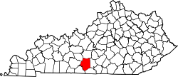
 Dry Fork Location within the state of Kentucky  Dry Fork Dry Fork (the United States) | |
| Coordinates: 36°48′55″N85°55′29″W / 36.81528°N 85.92472°W | |
| Country | |
| State | |
| County | Barren |
| Elevation | 820 ft (250 m) |
| Time zone | UTC−6 (CST) |
| • Summer (DST) | UTC−5 (CDT) |
| ZIP codes | 42123 |
| GNIS feature ID | 507876 [1] |
Dry Fork (or Dryfork) is a rural unincorporated community in southern Barren County, Kentucky, United States. [1] [2] Dry Fork is named for one of three forks of a local creek, which went dry in summer, located about "half a mile below Blue Spring at the Jacob Dillon old place". [3] Dry Fork had a post office from 1848 to 1943. [4]