Olmstead, Kentucky | |
|---|---|
 Olmstead  Olmstead | |
| Coordinates: 36°45′8″N87°00′54″W / 36.75222°N 87.01500°W | |
| Country | United States |
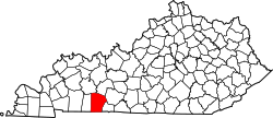
| State | Kentucky |
| County | Logan |
| Elevation | 581 ft (177 m) |
| Time zone | UTC-6 (Central (CST)) |
| • Summer (DST) | UTC-5 (CDT) |
| ZIP code | 42265 [1] |
| Area codes | 270 and 364 |
| GNIS feature ID | 499937 [2] |
Olmstead is an unincorporated community in Logan County, Kentucky, United States. [2]
Olmstead was a station on the L & N railroad between Bowling Green, KY and Clarksville, TN that opened in 1860. It was named after a leader in the effort to build the railroad. [3] Olmstead is also the site of an elementary and middle school. [4] A post office has been in operation until recently in Olmstead since 1862. [5]