Claymour, Kentucky

Last updated

Claymour
USA Kentucky location map.svg
Red pog.svg
Claymour
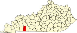
Location within the state of Kentucky
Coordinates: 36°53′12.15″N87°6′41.00″W / 36.8867083°N 87.1113889°W / 36.8867083; -87.1113889
CountryUnited States
State Kentucky
County Todd
Elevation
643 ft (196 m)
Time zone UTC-6 (Central (CST))
  Summer (DST) UTC-5 (CST)
Area codes 270 and 364
GNIS feature ID489594 [1]

Claymour is an unincorporated community in Todd County, Kentucky, United States. [1]

Contents

History

The community of Claymour was established primarily as a farming community sometime around the 1850s. [2]

Geography

Claymour is located on east-central Todd County about 5 miles (8.0 km) northeast of Elkton along Kentucky Route 106 (KY 106) at its junction with KY 507 and KY 178. [3]

Annual events

Claymour is home to a Christian-oriented annual event, the Claymour Camp Meeting, an outdoor revival meeting which has been held since 1903. [4] [5]

References

  1. 1 2 U.S. Geological Survey Geographic Names Information System: Claymour, Kentucky
  2. Glenn, Ray (May 14, 1967). "Horse Making Comeback In Todd's Claymour Area". Kentucky New Era . p. 18. Retrieved November 11, 2023 via Google Books.
  3. DeLorme (2010). Kentucky Atlas and Gazetteer (Map). Yarmouth, Maine: DeLorme. p. 79. § B10. ISBN   0-89933-340-0.
  4. "Claymour Camp Meeting celebrates 100th anniversary". Kentucky New Era . Hopkinsville, Kentucky. July 12, 2003. p. D1. Retrieved November 11, 2023 via Google Books.
  5. Sturges, Lynn (July 28, 1979). "Claymour Diamond Jubilee". Kentucky New Era. Hopkinsville, Kentucky. p. 14. Retrieved November 11, 2023 via Google Books.