Pleasureville, Kentucky

Last updated
Pleasureville, Kentucky
Downtownpleasurevilleky.JPG
Downtown Pleasureville (South Town)
Henry County Kentucky Incorporated and Unincorporated areas Pleasureville Highlighted 2161788.svg
Location of Pleasureville in Henry County, Kentucky.
Coordinates: 38°20′45″N85°06′59″W / 38.34583°N 85.11639°W / 38.34583; -85.11639
Country United States
State Kentucky
Counties Henry & Shelby
Incorporated1842 [1]
Government
  MayorWm. Rodney Young
Area
[2]
  Total0.49 sq mi (1.26 km2)
  Land0.48 sq mi (1.25 km2)
  Water0.00 sq mi (0.01 km2)
Elevation
[3]
899 ft (274 m)
Population
 (2020)
  Total779
  Density1,609.50/sq mi (621.62/km2)
Time zone UTC-5 (Eastern (EST))
  Summer (DST) UTC-4 (EDT)
ZIP code
40057
Area code 502
FIPS code 21-61788
GNIS feature ID2404540 [3]
Website pleasurevilleky.com

Pleasureville is a home rule-class city in Henry and Shelby counties, Kentucky, United States. The population was 834 at the time of the 2010 U.S. Census. [4]

Contents

History

In 1784, 30-odd Dutch Huguenot families colonizing present-day Mercer County purchased 10,000 acres (4,000 ha) from Squire Boone. They erected a fort for their protection about 1.5 miles (2.4 km) east of present-day north Pleasureville. Their land was held and cultivated in common, but managed by Abraham Banta. It was variously known as "The Dutch Tract", the "Low Dutch Settlement" or "Station", and "Bantatown", but the post office was established as "Pleasureville" c.1828, [5] and the city was incorporated under that name in 1842. [6] [1]

Rennick relates the local story that it derived from a visitor expressing what a pleasure it was to stay among such pleasant people. [5] This story was also detailed in an autobiography of Isaac Newton LeCompte in 1919, where he noted, "My Great Uncle, Major Joe LeCompte, who was a politician as well as a soldier, upon his rounds as a candidate for Congress (he was elected four terms) frequently passed through this village and upon one occasion he remarked that every time he passed through he heard the men whistling and the woman singing and suggested that the town should be named Pleasureville, and so it was." [7] Others say the area of the post office housed a bordello (at the site of the later Pleasureville Hotel and a present-day apartment building). [8]

In 1858, the Louisville and Nashville Railroad arrived, but its course ran about a mile south of the former community. The post office relocated to the new settlement around the depot in 1874, which received the name "Pleasureville", and the former city became known as "North Pleasureville". It received a separate post office under that name in 1879. The town and city merged in 1962, although the two halves are still sometimes called "North Town" and "South Town" by locals. [5]

Geography

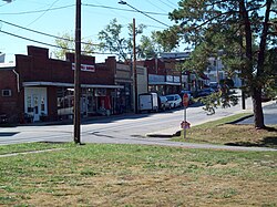
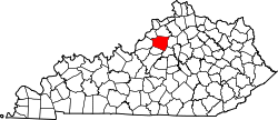
Pleasureville is located in southern Henry County in the Bluegrass region of Kentucky. A small portion of the "South Town" part of the city extends south into Shelby County. According to the United States Census Bureau, the city has a total area of 0.46 square miles (1.2 km2), all land. [4]

The community is located on Kentucky Route 241, which runs through both North and South Towns, and on U.S. Route 421, which runs through North Town. KY 241 leads south 13 miles (21 km) to Shelbyville (via Kentucky Route 43). US-421 leads northwest 6 miles (10 km) to New Castle, the Henry County seat, and southeast 23 miles (37 km) to Frankfort, the state capital.

Demographics

Historical population
CensusPop.Note
1880 175
1890 20215.4%
1900 27234.7%
1910 52291.9%
1920 308−41.0%
1930 34110.7%
1940 43828.4%
1950 355−18.9%
1960 46631.3%
1970 74760.3%
1980 83712.0%
1990 761−9.1%
2000 86914.2%
2010 834−4.0%
2020 779−6.6%
U.S. Decennial Census [9]

As of the census [10] of 2000, there were 869 people, 340 households, and 236 families residing in the city. The population density was 1,642.9 inhabitants per square mile (634.3/km2). There were 367 housing units at an average density of 693.8 per square mile (267.9/km2). The racial makeup of the city was 92.98% White, 1.73% African American, 0.12% Native American, 4.26% from other races, and 0.92% from two or more races. Hispanic or Latino of any race were 7.48% of the population.

There were 340 households, out of which 33.2% had children under the age of 18 living with them, 53.8% were married couples living together, 9.4% had a female householder with no husband present, and 30.3% were non-families. 23.8% of all households were made up of individuals, and 14.4% had someone living alone who was 65 years of age or older. The average household size was 2.56 and the average family size was 2.98.

In the city, the population was spread out, with 25.1% under the age of 18, 7.6% from 18 to 24, 31.5% from 25 to 44, 19.3% from 45 to 64, and 16.5% who were 65 years of age or older. The median age was 36 years. For every 100 females, there were 104.5 males. For every 100 females age 18 and over, there were 100.9 males.

The median income for a household in the city was $33,839, and the median income for a family was $36,875. Males had a median income of $26,875 versus $21,912 for females. The per capita income for the city was $16,279. About 5.9% of families and 13.8% of the population were below the poverty line, including 22.3% of those under age 18 and 9.9% of those age 65 or over.

Climate

The climate in this area is characterized by hot, humid summers and generally mild to cool winters. According to the Köppen Climate Classification system, Pleasureville has a humid subtropical climate, abbreviated "Cfa" on climate maps. [11]

See also

Related Research Articles

<span class="mw-page-title-main">Henry County, Kentucky</span> County in Kentucky, United States

Henry County is a county located in the north central portion of the U.S. state of Kentucky bordering the Kentucky River. As of the 2020 census, the population was 15,678. Its county seat is New Castle, but its largest city is Eminence. The county was founded in 1798 from portions of Shelby County. It was named for the statesman and governor of Virginia Patrick Henry. Henry County is included in the Louisville/Jefferson County, KY-IN Metropolitan Statistical Area. Since the 1990s, it has become an increasingly important exurb, especially as land prices have become higher in neighboring Oldham County. With regard to the sale of alcohol, it is classified as a wet county.

<span class="mw-page-title-main">Fleming County, Kentucky</span> County in Kentucky, United States

Fleming County is a county located in the U.S. state of Kentucky. As of the 2020 census, the population was 15,082. Its county seat is Flemingsburg. The county was formed in 1798 and named for Colonel John Fleming, an Indian fighter and early settler. It is a moist county. In 1998, the Kentucky General Assembly designated Fleming County as the Covered Bridge Capital of Kentucky.

<span class="mw-page-title-main">Morgantown, Kentucky</span> City in Kentucky, United States

Morgantown is a home rule-class city in, and the seat of Butler County, Kentucky, United States. The population was 2,471 at the time of the 2020 Census.

<span class="mw-page-title-main">Bardwell, Kentucky</span> City in Kentucky, United States

Bardwell is a home rule-class city in and the county seat of Carlisle County, Kentucky, United States. The city was formally incorporated by the state assembly in 1878. The population was 714 at the 2020 census, down from 723 in 2010.

<span class="mw-page-title-main">Liberty, Kentucky</span> City in Kentucky, United States

Liberty is a home rule-class city in Casey County, Kentucky, in the United States. It is the seat of its county. Its population was 2,168 at the 2010 U.S. census.

<span class="mw-page-title-main">Marion, Kentucky</span> City in Kentucky, United States

Marion is a home rule-class city in Crittenden County, Kentucky, in the United States. It is the seat of its county. As of the 2010 census, the city population was 3,039.

<span class="mw-page-title-main">Flemingsburg, Kentucky</span> City in Kentucky, United States

Flemingsburg is a home rule-class city in Fleming County, Kentucky, in the United States. The population was 2,658 at the 2010 census, down from 3,010 at the 2000 census. It is the seat of Fleming County.

<span class="mw-page-title-main">Lancaster, Kentucky</span> City in Kentucky, United States

Lancaster is a home rule-class city in Garrard County, Kentucky, in the United States. It is the seat of its county. As of the year 2010 U.S. census, the city population was 3,442.

<span class="mw-page-title-main">Caneyville, Kentucky</span> City in Kentucky, United States

Caneyville is a home rule-class city in Grayson County, Kentucky, in the United States. The population was 608 at the 2010 census. Named for its location on Caney Creek, Caneyville had a post office by 1837 and a town charter by 1840 and was incorporated by the state legislature in 1880.

<span class="mw-page-title-main">Columbus, Kentucky</span> City in Kentucky, United States

Columbus is a home rule-class city in Hickman County, Kentucky, in the United States. The population was 170 at the 2010 census, a decline from 229 in 2000. The city lies at the western end of the state, less than a mile from the Mississippi River.

<span class="mw-page-title-main">Hodgenville, Kentucky</span> City in Kentucky, United States

Hodgenville is a home rule-class city in LaRue County, Kentucky, United States. It is the seat of its county. Hodgenville sits along the North Fork of the Nolin River. The population was 3,206 at the 2010 census. It is included in the Elizabethtown metropolitan area.

<span class="mw-page-title-main">Blaine, Kentucky</span> City in Kentucky, United States

Blaine is a home rule-class city in Lawrence County, Kentucky, United States. The population was 47 at the 2010 census, down from 245 at the 2000 census.

<span class="mw-page-title-main">Kuttawa, Kentucky</span> City in Kentucky, United States

Kuttawa is a home rule-class city in Lyon County, Kentucky, in the United States. The population was 649 as of the 2010 census, up from 596 in 2000.

<span class="mw-page-title-main">Calhoun, Kentucky</span> City in Kentucky, United States

Calhoun is a home rule-class city in McLean County, Kentucky, United States. The population was 725 at the 2020 census. It is the county seat of McLean County. It is included in the Owensboro, Kentucky Metropolitan Statistical Area.

<span class="mw-page-title-main">Frenchburg, Kentucky</span> City in Kentucky, United States

Frenchburg is a home rule-class city in Menifee County, Kentucky, in the United States. The population was 601 at the 2020 census, up from 486 in 2010. It is the seat and only incorporated city in its rural county. It is located at the junction of U.S. Route 460 and Kentucky Route 36. Logging is the primary industry.

<span class="mw-page-title-main">Edmonton, Kentucky</span> City in Kentucky, United States

Edmonton is a home rule-class city in and the county seat of Metcalfe County, Kentucky, United States. It is part of the Glasgow Micropolitan Statistical Area. The population was 1,671 at the 2020 census.

<span class="mw-page-title-main">Gamaliel, Kentucky</span> City in Kentucky, United States

Gamaliel is a home rule-class city in Monroe County, Kentucky, in the United States. The population was 391 at the 2020 census.

<span class="mw-page-title-main">Beaver Dam, Kentucky</span> City in Kentucky, United States

Beaver Dam is a home rule-class city in Ohio County, Kentucky, in the United States. The population was 3,409 at the 2010 census, and it is the most populous community in the county. It is named for the Beaver Dam Baptist Church which predates the town by several decades. The city was formally incorporated by the state assembly in 1873.

<span class="mw-page-title-main">Jamestown, Kentucky</span> City in Kentucky, United States

Jamestown is a home rule-class city in Russell County, Kentucky, in the United States. It is the seat of its county. The population was 1,794 at the 2010 U.S. census.

<span class="mw-page-title-main">Sturgis, Kentucky</span> City in Kentucky, United States

Sturgis is a home rule-class city in Union County, Kentucky, United States. The population was 1,898 at the 2010 census. Located in northwest Kentucky, the city was founded in 1890 and named for Samuel Sturgis, who owned the land now occupied by the city.

References

  1. 1 2 Commonwealth of Kentucky. Office of the Secretary of State. Land Office. "Pleasureville, Kentucky". Accessed 27 September 2013.
  2. "2020 U.S. Gazetteer Files". United States Census Bureau. Retrieved March 18, 2022.
  3. 1 2 U.S. Geological Survey Geographic Names Information System: Pleasureville, Kentucky
  4. 1 2 "Geographic Identifiers: 2010 Demographic Profile Data (G001): Pleasureville city, Kentucky". American Factfinder. U.S. Census Bureau. Retrieved July 5, 2017.[ dead link ]
  5. 1 2 3 Rennick, Robert. Kentucky Place Names, p. 238. University Press of Kentucky (Lexington), 1987. Accessed 27 September 2013.
  6. Collins, Lewis (1877). History of Kentucky. p. 339.
  7. LeCompte, Isaac Newton (1919). LeCompte Family manuscript (unpublished). p. 12.
  8. University of Kentucky. Kentucky Atlas & Gazetteer. "Pleasureville".
  9. "Census of Population and Housing". Census.gov. Retrieved June 4, 2015.
  10. "U.S. Census website". United States Census Bureau . Retrieved 2008-01-31.
  11. Climate Summary for Pleasureville, Kentucky