
Shelby County is a county located in the U.S. state of Kentucky. As of the 2020 census, the population was 48,065. Its county seat is Shelbyville. The county was established in 1792 and named for Isaac Shelby, the first Governor of Kentucky. Shelby County is part of the Louisville/Jefferson County, KY–IN Metropolitan Statistical Area. Shelby County's motto is "Good Land, Good Living, Good People".

Mulberry is a city in Polk County, Florida, United States. The population was 3,817 at the 2010 census. Mulberry is home to Badcock Home Furniture. It is part of the Lakeland–Winter Haven Metropolitan Statistical Area, with parts of unincorporated Lakeland on its northern boundary. Mulberry is home to the 334-acre Alafia River Reserve.

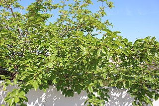
Morus, a genus of flowering plants in the family Moraceae, consists of diverse species of deciduous trees commonly known as mulberries, growing wild and under cultivation in many temperate world regions. Generally, the genus has 64 subordinate taxa, three of which are well-known and are ostensibly named for the fruit color of the best-known cultivar: white, red, and black mulberry, with numerous cultivars and some taxa currently unchecked and awaiting taxonomic scrutiny. M. alba is native to South Asia, but is widely distributed across Europe, Southern Africa, South America, and North America. M. alba is also the species most preferred by the silkworm, and is regarded as an invasive species in Brazil and the United States.

Mulberry harbours were two temporary portable harbours developed by the British Admiralty and War Office during the Second World War to facilitate the rapid offloading of cargo onto beaches during the Allied invasion of Normandy in June 1944. After the Allies successfully held beachheads following D-Day, two prefabricated harbours were taken in sections across the English Channel from southern England with the invading armies and assembled off Omaha Beach and Gold Beach.
Morus alba, known as white mulberry, common mulberry and silkworm mulberry, is a fast-growing, small to medium-sized mulberry tree which grows to 10–20 m (33–66 ft) tall. It is generally a short-lived tree with a lifespan comparable to that of humans, although there are some specimens known to be more than 250 years old. The species is native to China and India and is widely cultivated and naturalized elsewhere.
Mulberry is the common name of several trees in the genus Morus. See the list of plants known as mulberry for plants with similar names.

'And to Think That I Saw It on Mulberry Street' is Theodore Seuss Geisel's first children's book published under the name Dr. Seuss. First published by Vanguard Press in 1937, the story follows a boy named Marco, who describes a parade of imaginary people and vehicles traveling along a road, Mulberry Street, in an elaborate fantasy story he dreams up to tell his father at the end of his walk. However, when he arrives home, he decides instead to tell his father what he actually saw—a simple horse and wagon.

Kentucky Route 3005 serves as a northern bypass of Elizabethtown. Locally, it is known as Ring Road. It originates outside the western limits of Elizabethtown at an interchange with Western Kentucky Parkway. The road then takes a wide circuit to the north of the city, eventually entering the city limits. Its eastern terminus is at U.S. 62, here known as Mulberry Street, within the city limits and approximately 1 mile (1.6 km) west of Interstate 65.
The Missouri National Recreational River is a National Recreational River located on the border between Nebraska and South Dakota. The designation was first applied in 1978 to a 59-mile section of the Missouri River between Gavins Point Dam and Ponca State Park. In 1991, an additional 39-mile section between Fort Randall Dam and Niobrara, Nebraska, was added to the designation. These two stretches of the Missouri River are the only parts of the river between Montana and the mouth of the Missouri that remain undammed or unchannelized. The last 20 miles of the Niobrara River and 6 miles of Verdigre Creek were also added in 1991.

Edmondson Village is a neighborhood in the southwestern section of Baltimore, Maryland, encompassing most of the Edmondson Avenue corridor in 21229. The Edmondson Village area is made up of several smaller communities. Its communities include Hunting Ridge, Uplands, Rognel Heights, Wildwood, West Mulberry, Allendale, Edgewood, and Lower Edmondson Village. It is located north of Frederick Avenue, and south of the Gwynns Falls Parkway, Leakin and Gwynns Falls Parks. Communities in the area range from middle class to lower income. A notable shopping center opened in the neighborhood in 1947.
Thomas House and variations may refer to:
Oghi is an Armenian spirit distilled from fruits or berries. It is widely produced as moonshine from home-grown garden fruits all across Armenia, where it is served as a popular welcome drink to guests and is routinely drunk during meals. Arguably, Armenian oghi is not "vodka" at all and merely became thought of as such during the Soviet era in Armenia.
Mulberry Hill may refer to:
Home Economics Building may refer to:

Kentucky Route 28 (KY 28) is a 36.217-mile-long (58.286 km) state highway in the U.S. state of Kentucky that travels from KY 11 and KY 30 in Booneville to KY 15 in northern rural Perry County via Cow Creek, Arnett, Buckhorn, and Chavies. KY 28 begins in Booneville by traveling concurrently with KY 30 east while KY 30 west travels through town to the northwest. KY 30 veers off at the official beginning of KY 28 at Mulberry Street. KY 28 heads out of Booneville in Owsley County, heading southeast. About 11 miles (18 km) southeast of Booneville, KY 28 enters Breathitt County. After about 6 miles (9.7 km) through Breathitt County, KY 28 enters Perry County. KY 28 passes through the community of Buckhorn before making a short reentry into Breathitt County. After returning to Perry County, KY 28 passes through the community of Chavies before ending at KY 15 at Grapevine in Perry County.

Columbus Park formerly known as Mulberry Bend Park, Five Points Park and Paradise Park, is a public park in Chinatown, Manhattan, in New York City that was built in 1897.

Hebetica sylviae is a member of the treehopper family Membracidae. It is found in the eastern United States, first discovered in Murray, Kentucky, with a second sighting in Atlanta, Georgia.

The John C. Brown House, in Shelby County, Kentucky near Mulberry, Kentucky, was built around 1837, and it has additions done in approximately the 1960s. It was listed on the National Register of Historic Places in 1988. The property was deemed significant under the National Registers' criterion for design and construction, "as a well-preserved example of the early 19th century (1810-1840) 1-story, frame, center-passage, single-pile plan in Shelby County," balancing out the several different-but-from-the-same-period frame I-houses which had been identified in the study. It features "antebellum vernacular" style and was built c. 1837. It was listed as a result of a large 1986-1987 study of the historic resources of Shelby County.


