Germantown, Kentucky

Last updated
Germantown, Kentucky
Bracken County Kentucky Incorporated and Unincorporated areas Germantown Highlighted 2130718.svg
Location in Bracken County, Kentucky.
Coordinates: 38°39′21″N83°57′51″W / 38.65583°N 83.96417°W / 38.65583; -83.96417
Country United States
State Kentucky
Counties Bracken, Mason
Named for German immigrants
Area
[1]
  Total0.12 sq mi (0.32 km2)
  Land0.12 sq mi (0.32 km2)
  Water0.00 sq mi (0.00 km2)
Elevation
[2]
948 ft (289 m)
Population
 (2020) [3]
  Total146
  Density1,196.72/sq mi (460.41/km2)
Time zone UTC-5 (Eastern (EST))
  Summer (DST) UTC-4 (EDT)
ZIP code
41044
Area code 606
FIPS code 21-30718
GNIS feature ID2403692 [2]

Germantown is a home rule-class city in Bracken and Mason counties in the U.S. state of Kentucky. The population was 146 at the 2020 census. [3]

Contents

The Bracken County portion of Germantown is part of the Cincinnati/Northern Kentucky metropolitan area, while the Mason County portion is part of the Maysville micropolitan area.

History

Germantown was platted in 1794 and named after German immigrants. [4] The city was incorporated by the Virginia state legislature in 1795. [5] [6] A post office called "Germantown" has been in operation since 1817. [7]

Geography

Germantown is located primarily in eastern Bracken County and extends into western Mason County. Kentucky Route 10 passes through the center of town, leading east (via Kentucky Route 9) 13 miles (21 km) to Maysville on the Ohio River, and west 6 miles (10 km) to Brooksville, the Bracken County seat.

According to the U.S. Census Bureau, Germantown has a total area of 0.12 square miles (0.31 km2), all land. [1] The city sits on a ridge that drains north to Bracken Creek, east to Pommel Creek, south to Two Lick Creek, and southwest to Camp Creek. Bracken Creek is a direct tributary of the Ohio River, joining it at Augusta, while the other three creeks are all tributaries of the North Fork of the Licking River, which flows northwest to join the Ohio River at Covington and Newport.

Demographics

Historical population
CensusPop.Note
1800 81
1810 36−55.6%
1830 118
1850 125
1860 17036.0%
1870 19112.4%
1890 229
1900 40777.7%
1910 287−29.5%
1920 237−17.4%
1930 28319.4%
1940 3047.4%
1950 260−14.5%
1960 251−3.5%
1970 33232.3%
1980 3474.5%
1990 213−38.6%
2000 190−10.8%
2010 154−18.9%
2020 146−5.2%
U.S. Decennial Census [8]

As of the census [9] of 2000, there were 190 people, 81 households, and 55 families residing in the city. The population density was 703.5 inhabitants per square mile (271.6/km2). There were 85 housing units at an average density of 314.7 per square mile (121.5/km2). The racial makeup of the city was 98.42% White and 1.58% African American.

There were 81 households, out of which 29.6% had children under the age of 18 living with them, 60.5% were married couples living together, 6.2% had a female householder with no husband present, and 30.9% were non-families. 27.2% of all households were made up of individuals, and 14.8% had someone living alone who was 65 years of age or older. The average household size was 2.35 and the average family size was 2.77.

In the city, the population was spread out, with 22.6% under the age of 18, 7.9% from 18 to 24, 32.1% from 25 to 44, 17.9% from 45 to 64, and 19.5% who were 65 years of age or older. The median age was 39 years. For every 100 females, there were 88.1 males. For every 100 females age 18 and over, there were 86.1 males.

The median income for a household in the city was $27,500, and the median income for a family was $32,500. Males had a median income of $20,833 versus $22,813 for females. The per capita income for the city was $16,973. About 9.7% of families and 11.8% of the population were below the poverty line, including 16.7% of those under the age of eighteen and 20.4% of those 65 or over.

Government

The government of Germantown is composed of a mayor and four city council members. Council members are elected every two years on even numbered years and the mayor is elected every four years, also on even years. The council member receiving the most votes in the council elections is designated as the vice-mayor.

The city also contains the Germantown Volunteer Fire Department, established in 1927, that operates in Bracken and Mason counties as a fire, rescue, and EMS first responder service.

Notable people

Related Research Articles

<span class="mw-page-title-main">Brown County, Ohio</span> County in Ohio, United States

Brown County is a county in the U.S. state of Ohio. As of the 2020 United States Census, the population was 43,676. The county seat and largest city is Georgetown. The county was created in 1818 and is named for Major General Jacob Brown, an officer in the War of 1812 who was wounded at the Battle of Lundy's Lane. Brown County is part of the Cincinnati-Middletown, OH-KY-IN Metropolitan Statistical Area.

<span class="mw-page-title-main">Robertson County, Kentucky</span> County in Kentucky, United States

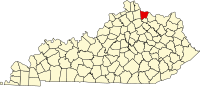
Robertson County is a county located in the U.S. Commonwealth of Kentucky. As of the 2020 census, the population was 2,193. Its county seat is Mount Olivet. The county is named for George Robertson, a Kentucky Congressman from 1817 to 1821. It is Kentucky's smallest county by both total area and by population.

<span class="mw-page-title-main">Pendleton County, Kentucky</span> County in Kentucky, United States

Pendleton County is a county located in the U.S. state of Kentucky. As of the 2020 census, the population was 14,644. Its county seat is Falmouth. The county was founded December 13, 1798. Pendleton County is included in the Cincinnati-Middletown, OH-KY-IN Metropolitan Statistical Area.

<span class="mw-page-title-main">Mason County, Kentucky</span> County in Kentucky, United States

Mason County is a county located in the U.S. state of Kentucky. As of the 2020 census, the population was 17,120. Its county seat is Maysville. The county was created from Bourbon County, Virginia in 1788 and named for George Mason, a Virginia delegate to the U.S. Constitutional Convention known as the "Father of the Bill of Rights". Mason County comprises the Maysville, KY Micropolitan Statistical Area, which is included in the Cincinnati-Wilmington-Maysville, OH-KY-IN Combined Statistical Area.

<span class="mw-page-title-main">Bracken County, Kentucky</span> County in Kentucky, United States

Bracken County is a county located in the U.S. state of Kentucky. As of the 2020 census, the population was 8,400. Its county seat is Brooksville. The county was formed in 1796. Bracken County is included in the Cincinnati-Middletown, OH-KY-IN Metropolitan Statistical Area.

<span class="mw-page-title-main">Bourbon County, Kentucky</span> County in Kentucky, United States

Bourbon County is a county located in the U.S. state of Kentucky. As of the 2020 census, the population was 20,252. Its county seat is Paris. Bourbon County is part of the Lexington–Fayette, KY Metropolitan Statistical Area. It is one of Kentucky's nine original counties, and is best known for its historical association with bourbon whiskey.

<span class="mw-page-title-main">Augusta, Kentucky</span> City in Kentucky, United States

Augusta is a home rule-class city in Bracken County, Kentucky, in the United States. It is sited upon the southern bank of the Ohio River. As of the 2010 census, the city population was 1,190. When Bracken County was organized in 1796, Augusta was the county seat. In 1839, a new county courthouse was built at a more central location in Brooksville. The city was formally incorporated by the state assembly in 1850.

<span class="mw-page-title-main">Brooksville, Kentucky</span> City in Kentucky, United States

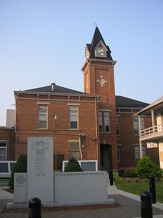
Brooksville is a home rule-class city in Bracken County, Kentucky, in the United States. As of the 2010 census, the city's population was 642. It is the county seat of Bracken County.

<span class="mw-page-title-main">Cold Spring, Kentucky</span> City in Kentucky, United States

Cold Spring is a home rule-class city in Campbell County, Kentucky, in the United States. The population was 5,912 at the 2010 census, up from 3,806 at the 2000 census. It is part of the Cincinnati-Northern Kentucky metropolitan area.

<span class="mw-page-title-main">Greenup, Kentucky</span> City in Kentucky, United States

Greenup is a home rule-class city located at the confluence of the Little Sandy River with the Ohio River in Greenup County, Kentucky, United States. The population was 1,188 at the 2010 census. Greenup is one of three county seats in the Commonwealth of Kentucky to share its name with its county; the other two being Harlan and Henderson.

<span class="mw-page-title-main">Vine Grove, Kentucky</span> City in Kentucky, United States

Vine Grove is a home rule-class city in Hardin County, Kentucky, United States. The population was 4,520 at the 2010 census, up from 4,169 at the 2000 census. It is part of the Elizabethtown–Fort Knox Metropolitan Statistical Area.

<span class="mw-page-title-main">Concord, Kentucky</span> City in Kentucky, United States

Concord is a home rule-class city in Lewis County, Kentucky, in the United States. The population was 35 at the 2010 census. It is part of the Maysville Micropolitan Statistical Area.

<span class="mw-page-title-main">Vanceburg, Kentucky</span> City in Kentucky, United States

Vanceburg is a home rule-class city in Lewis County, Kentucky, United States, along the Ohio River. The population was 1,428 at the 2020 census. It is the county seat of Lewis County.

<span class="mw-page-title-main">Carrsville, Kentucky</span> City in Kentucky, United States

Carrsville is a home rule-class city beside the Ohio River in Livingston County, Kentucky, in the United States. The population was 50 at the 2010 census, declining from 64 as of 2000. It is part of the Paducah, KY-IL Micropolitan Statistical Area. It is situated just west of the junction of where Buck Creek empties into the Ohio River.

<span class="mw-page-title-main">Dover, Kentucky</span> City in Kentucky, United States

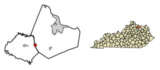
Dover is a home rule-class city in Mason County, Kentucky, United States. The population was 221 at the 2020 census, down from 252 in 2010. It is part of the Maysville Micropolitan Statistical Area.

<span class="mw-page-title-main">Maysville, Kentucky</span> City in Kentucky, United States

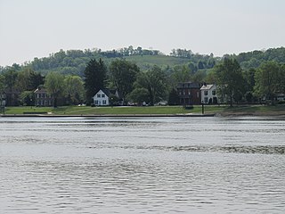
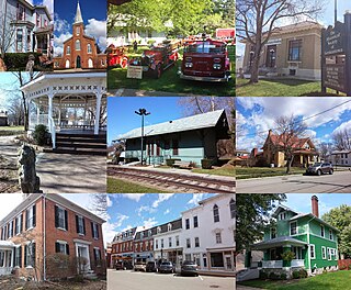
Maysville is a home rule-class city in Mason County, Kentucky, United States, and is the seat of Mason County. The population was 8,873 as of the 2020 census. Maysville is on the Ohio River, 66 miles (106 km) northeast of Lexington. It is the principal city of the Maysville Micropolitan Statistical Area, which comprises Mason County. Two bridges cross the Ohio from Maysville to Aberdeen, Ohio: the Simon Kenton Memorial Bridge built in 1931 and the William H. Harsha Bridge built in 2001.

<span class="mw-page-title-main">Sardis, Kentucky</span> City in Kentucky, United States

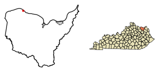
Sardis is a home rule-class city in Mason and Robertson counties in the U.S. state of Kentucky. The population was 60 as of the 2020 census, down from 103 in 2010.

<span class="mw-page-title-main">Germantown, Ohio</span> City in Ohio, United States

Germantown is a city in Montgomery County, Ohio, United States. The population was 5,796 at the 2020 census. A part of the Dayton metropolitan area, Germantown was founded by German Americans from Pennsylvania and was once home to a cigar industry.

<span class="mw-page-title-main">Sparta, Kentucky</span> City in Kentucky, United States

Sparta is a home rule-class city in Gallatin and Owen counties in the U.S. state of Kentucky. The population was 231 at the 2010 census.

<span class="mw-page-title-main">Prospect, Kentucky</span> City in Kentucky, United States

Prospect is a home rule-class city in Jefferson and Oldham counties in the U.S. state of Kentucky. The Jefferson County portion is a part of the Louisville Metro government. The population was 4,698 at the time 2010 census. It is one of the wealthiest communities in Kentucky.

References

  1. 1 2 "2022 U.S. Gazetteer Files: Kentucky". United States Census Bureau. Retrieved May 5, 2023.
  2. 1 2 U.S. Geological Survey Geographic Names Information System: Germantown, Kentucky
  3. 1 2 "P1. Race – Germantown city, Kentucky: 2020 DEC Redistricting Data (PL 94-171)". U.S. Census Bureau. Retrieved May 5, 2023.
  4. Toncray, Marla (March 9, 2012). "History, origins and towns of Bracken County". The Ledger Independent. Archived from the original on 4 September 2015. Retrieved 11 January 2016.
  5. Rennick, Robert. Kentucky Place Names, p. 115. "Germantown". University Press of Kentucky (Lexington), 1987. Accessed 26 July 2013.
  6. Collins, Lewis (1877). History of Kentucky. p. 547.
  7. "Bracken County". Jim Forte Postal History. Archived from the original on 3 July 2011. Retrieved 11 January 2015.
  8. "Census of Population and Housing". Census.gov. Retrieved June 4, 2015.
  9. "U.S. Census website". United States Census Bureau . Retrieved 2008-01-31.