Burgin, Kentucky

Last updated

Burgin, Kentucky
Burgin-KY152-ky.jpg
Main Street (KY 152) in Burgin
Mercer County Kentucky Incorporated and Unincorporated areas Burgin Highlighted 2111044.svg
Location of Burgin in Mercer County, Kentucky.
USA Kentucky location map.svg
Red pog.svg
Burgin, Kentucky
Location of Burgin, Kentucky
Coordinates: 37°45′16″N84°45′48″W / 37.75444°N 84.76333°W / 37.75444; -84.76333
Country United States
State Kentucky
County Mercer
Settled1877
Incorporated1878-03-14 [1]
Government
   Mayor Jim Caldwell
   City Council Debbie Hayslett
George Hensley
Chris Cooper
Joey Hardin
Christine McGrath
Joe Sanders [1]
Area
[2]
  Total1.26 sq mi (3.28 km2)
  Land1.26 sq mi (3.25 km2)
  Water0.01 sq mi (0.02 km2)
Elevation
[3]
863 ft (263 m)
Population
 (2020)
  Total979
  Density779.46/sq mi (300.94/km2)
Time zone UTC-5 (Eastern (EST))
  Summer (DST) UTC-4 (EDT)
ZIP code
40310
Area code 859
FIPS code 21-11044
GNIS feature ID2403954 [3]

Burgin is a home rule-class city in Mercer County, Kentucky, in the United States. Its population was 965 at the 2010 census.

Contents

History

What is now Burgin was originally known as "Cane Run." [4] In 1874, the Cincinnati Southern Railway obtained a right-of-way from local landowner Temple Burgin and opened Burgin Station. The town was established in 1877 and incorporated in 1878. The post office opened as "Bergen" in 1877 and changed its name to "Burgin" in 1886. [4]

Geography

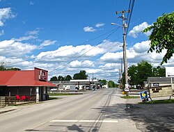
The city is concentrated along Kentucky Route 152 (Main Street), with most of its public buildings lying just west of the highway's intersection with Kentucky Route 33 (Danville Street/Pleasant Hill Drive). Harrodsburg lies to the west of Burgin along KY 152, and Danville lies to the south along KY 33. Burgin is located at the headwaters of Cane Run, which flows eastward into the Dix River.

According to the United States Census Bureau, the city has a total area of 1.2 square miles (3.1 km2), all land.

Climate

The climate in this area is characterized by hot, humid summers and generally mild to cool winters. According to the Köppen Climate Classification system, Burgin has a humid subtropical climate, abbreviated "Cfa" on climate maps. [5]

Demographics

Historical population
CensusPop.Note
1880 150
1890 303102.0%
1900 703132.0%
1910 679−3.4%
1920 7135.0%
1930 79110.9%
1940 703−11.1%
1950 77710.5%
1960 87913.1%
1970 1,00214.0%
1980 1,0080.6%
1990 1,0090.1%
2000 874−13.4%
2010 96510.4%
2020 9791.5%
U.S. Decennial Census [6]

As of the census [7] of 2000, there were 874 people, 372 households, and 258 families residing in the city. The population density was 750.8 per square mile (289.9/km2). There were 407 housing units at an average density of 349.6 per square mile (135.0/km2). The racial makeup of the city was 93.02% White, 3.89% African American, 0.34% Native American, 0.11% Pacific Islander, 0.69% from other races, and 1.95% from two or more races. Hispanic or Latino of any race were 0.69% of the population.

There were 372 households, out of which 29.8% had children under the age of 18 living with them, 55.6% were married couples living together, 9.9% had a female householder with no husband present, and 30.6% were non-families. 28.2% of all households were made up of individuals, and 14.5% had someone living alone who was 65 years of age or older. The average household size was 2.35 and the average family size was 2.87.

22.9% of the population was under the age of 18, 7.6% from 18 to 24, 28.0% from 25 to 44, 21.7% from 45 to 64, and 19.8% who were 65 years of age or older. The median age was 39 years. For every 100 females, there were 93.8 males. For every 100 females age 18 and over, there were 87.2 males.

The median income for a household in the city was US $34,135, and the median income for a family was $41,442. Males had a median income of $31,324 versus $21,400 for females. The per capita income for the city was $16,756. About 9.8% of families and 11.8% of the population were below the poverty line, including 13.4% of those under age 18 and 13.8% of those age 65 or over.

Education

Burgin is served by Burgin Independent Schools. [8]

Notable natives

Related Research Articles

<span class="mw-page-title-main">Mercer County, Kentucky</span> County in Kentucky, United States

Mercer County is a county located in the central part of the U.S. Commonwealth of Kentucky. As of the 2020 census, the population was 23,772. Its county seat is Harrodsburg. The county was formed from Lincoln County, Virginia in 1785 and is named for Revolutionary War General Hugh Mercer, who was killed at the Battle of Princeton in 1777. It was formerly a prohibition or dry county.

<span class="mw-page-title-main">Boyle County, Kentucky</span> County in Kentucky, United States

Boyle County is a county located in the central part of Kentucky. As of the 2020 census, the population was 30,614. Its county seat is Danville. The county was formed in 1842 and named for John Boyle (1774–1835), a U.S. Representative, chief justice of the Kentucky Court of Appeals, and later federal judge for the District of Kentucky, and is part of the Danville, KY Micropolitan Statistical Area.

<span class="mw-page-title-main">Scottsburg, Indiana</span> City in Indiana, United States

Scottsburg is a city within Vienna Township and the county seat of Scott County, in the U.S. state of Indiana, about 30 miles (48 km) north of Louisville, Kentucky. The population of Scottsburg was 7,345 at the 2020 census.

<span class="mw-page-title-main">Perryville, Kentucky</span> City in Kentucky, United States

Perryville is a home rule-class city along the Chaplin River in western Boyle County, Kentucky, in the United States. The population was 751 at the time of the 2010 U.S. Census. It is part of the Danville Micropolitan Statistical Area.

<span class="mw-page-title-main">Alexandria, Kentucky</span> City in Kentucky, United States

Alexandria is a home rule-class city in Campbell County, Kentucky, in the United States. Along with Newport, it is one of the dual seats of the county. The population was 10,341 at the 2020 census.

<span class="mw-page-title-main">Bardwell, Kentucky</span> City in Kentucky, United States

Bardwell is a home rule-class city in and the county seat of Carlisle County, Kentucky, United States. The city was formally incorporated by the state assembly in 1878. The population was 714 at the 2020 census, down from 723 in 2010.

<span class="mw-page-title-main">Grayson, Kentucky</span> City in Kentucky, United States

Grayson is a home rule-class city in and the county seat of Carter County, Kentucky, United States, on US Route 60 and Interstate 64 in the state's northeastern region. It is approximately 21 miles west of Ashland. Within the city limits, the population was 4,217 at the 2010 census. Along with Carter County, the city is closely associated with the nearby Huntington-Ashland, WV-KY-OH Metropolitan Statistical Area and is often erroneously included in the MSA being just 9 miles west of the M.S.A's western boundary.

<span class="mw-page-title-main">Burkesville, Kentucky</span> City in Kentucky, United States

Burkesville is a home rule-class city in Cumberland County, Kentucky, in the United States. Nestled among the rolling foothills of Appalachia and bordered by the Cumberland River to the south and east, it is the seat of its county. The population was 1,521 at the 2010 census.

<span class="mw-page-title-main">Greensburg, Kentucky</span> City in Kentucky, United States

Greensburg is a home rule-class city in and the county seat of Green County, Kentucky, United States. The population was 2,163 at the 2010 census, down from 2,396 at the 2000 census.

<span class="mw-page-title-main">Cynthiana, Kentucky</span> City in Kentucky, United States

Cynthiana is a home rule-class city in Harrison County, Kentucky, in the United States. The population was 6,402 at the 2010 census. It is the seat of its county.

<span class="mw-page-title-main">Anchorage, Kentucky</span> City in Kentucky, United States

Anchorage is a home rule-class city in eastern Jefferson County, Kentucky, United States. The population was 2,348 at the 2010 census and an estimated 2,432 in 2018. It is a suburb of Louisville.

<span class="mw-page-title-main">Whitesburg, Kentucky</span> City in Kentucky, United States

Whitesburg is a home rule-class city in and the county seat of Letcher County, Kentucky, United States. The population was 2,139 at the 2010 census and an estimated 1,875 in 2018. It was named for John D. White, a state politician.

<span class="mw-page-title-main">Crab Orchard, Kentucky</span> City in Kentucky, United States

Crab Orchard is a home rule-class city in Lincoln County, Kentucky, United States. The population was 841 at the 2010 census. It is part of the Danville Micropolitan Statistical Area.

<span class="mw-page-title-main">Stearns, Kentucky</span> Census-designated place in Kentucky, United States

Stearns is an unincorporated community and census-designated place (CDP) in McCreary County, Kentucky, United States. The population was 1,365 at the 2020 census. It was founded by Justus Smith Stearns.

<span class="mw-page-title-main">Hazard, Kentucky</span> City in Kentucky, United States

Hazard is a home rule-class city in, and the county seat of, Perry County, Kentucky, United States. The population was 5,263 at the 2020 Census.

<span class="mw-page-title-main">Elkton, Kentucky</span> City in Kentucky, United States

Elkton is a home rule-class city in and the county seat of Todd County, Kentucky, United States. The population was 2,062 at the 2010 census.

<span class="mw-page-title-main">Springfield, Kentucky</span> City in Kentucky, United States

Springfield is a home rule-class city in and county seat of Washington County, Kentucky, United States. The population was 2,846 at the 2020 census.

<span class="mw-page-title-main">Jewett, Texas</span> City in Texas, United States

Jewett is a city in Leon County, Texas, United States. The population was 1,167 at the 2010 census. It was laid out in 1871 by the International Railroad Company.

<span class="mw-page-title-main">Junction City, Kentucky</span> City in Kentucky, United States

Junction City is a home rule-class city in Boyle County on its border with Lincoln County in the U.S. state of Kentucky. Junction City's population was 2,241 at the 2010 U.S. census. It is part of the Danville Micropolitan Statistical Area.

<span class="mw-page-title-main">Eubank, Kentucky</span> City in Kentucky, United States

Eubank is a home rule-class city in Pulaski and Lincoln counties in southern Kentucky. The population was 319 at the 2010 census.

References

  1. 1 2 "Kentucky Cities and Counties: Burgin". Kentucky Secretary of State: Land Office. Archived from the original on June 6, 2011. Retrieved July 15, 2009.
  2. "2020 U.S. Gazetteer Files". United States Census Bureau. Retrieved March 18, 2022.
  3. 1 2 U.S. Geological Survey Geographic Names Information System: Burgin, Kentucky
  4. 1 2 "Kentucky Atlas and Gazetteer: Burgin". University of Kentucky . Retrieved July 15, 2009.
  5. Climate Summary for Burgin, Kentucky
  6. "Census of Population and Housing". Census.gov. Retrieved June 4, 2015.
  7. "U.S. Census website". United States Census Bureau . Retrieved January 31, 2008.
  8. Education, Kentucky Department of (October 29, 2009). "County & Independent School Districts" (PDF). Archived from the original (PDF) on January 10, 2010. Retrieved April 3, 2010.
  9. "Dillon Carmichael biography". AllMusic. Retrieved March 9, 2020.
  10. "Jack Coleman NBA & ABS Statistics". Sports Reference. Retrieved April 3, 2010.
  11. "Lt. Governor Jacqueline Coleman". ky.gov.
  12. Ann, Elizabeth (April 2, 2010). "Marie McDonald Online - Marie's Story". Archived from the original on March 6, 2010. Retrieved April 3, 2010.