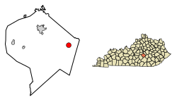
Crab Orchard, Kentucky | |
---|---|
Coordinates: 37°27′46″N84°30′24″W / 37.46278°N 84.50667°W | |
Country | United States |
State | Kentucky |
County | Lincoln |
Government | |
• Mayor | David Fraser [1] |
Area | |
• Total | 1.76 sq mi (4.55 km2) |
• Land | 1.75 sq mi (4.52 km2) |
• Water | 0.01 sq mi (0.03 km2) |
Elevation | 942 ft (287 m) |
Population (2020) | |
• Total | 744 |
• Density | 426.12/sq mi (164.54/km2) |
Time zone | UTC-5 (Eastern (EST)) |
• Summer (DST) | UTC-4 (EDT) |
ZIP code | 40419 |
Area code | 606 |
FIPS code | 21-17956 |
GNIS feature ID | 2404143 [3] |
Crab Orchard is a home rule-class city in Lincoln County, Kentucky, United States. The population was 841 at the 2010 census. [4] It is part of the Danville Micropolitan Statistical Area.
Crab Orchard was near the end of the Logan Trace of the Wilderness Road and was an early pioneer station. There are several mineral springs in the area, and from 1827 until 1922, taverns and hotels were located at Crab Orchard Springs. The post office was established in 1815, with Archibald Shanks its first postmaster. [5] [6]
Crab Orchard was a station on the Louisville and Nashville Railroad. [7]
Crab Orchard was the birthplace of Thomas L. Smith, a mountain man also known as "Pegleg" Smith.
Crab Orchard is located in eastern Lincoln County in the Knobs 3 miles west of the Rockcastle County line. U.S. Route 150 passes around the southern and western edges of the city, leading northwest 11 miles (18 km) to Stanford, the county seat, and southeast 13 miles (21 km) to Mount Vernon. Kentucky Route 39 passes through Crab Orchard as Main Street, leading north 12 miles (19 km) to Lancaster and south 28 miles (45 km) to Somerset.
According to the United States Census Bureau, Crab Orchard has a total area of 1.8 square miles (4.6 km2), of which 0.01 square miles (0.03 km2), or 0.66%, are water. [8] The city is 1 mile (1.6 km) southwest of the Dix River, a northwest-flowing tributary of the Kentucky River.
Census | Pop. | Note | %± |
---|---|---|---|
1830 | 234 | — | |
1860 | 364 | — | |
1870 | 631 | 73.4% | |
1880 | 538 | −14.7% | |
1890 | 453 | −15.8% | |
1900 | 385 | −15.0% | |
1910 | 467 | 21.3% | |
1920 | 493 | 5.6% | |
1930 | 576 | 16.8% | |
1940 | 705 | 22.4% | |
1950 | 757 | 7.4% | |
1960 | 808 | 6.7% | |
1970 | 861 | 6.6% | |
1980 | 843 | −2.1% | |
1990 | 825 | −2.1% | |
2000 | 842 | 2.1% | |
2010 | 841 | −0.1% | |
2020 | 744 | −11.5% | |
U.S. Decennial Census [9] |
As of the census [10] of 2000, there were 842 people, 373 households, and 227 families residing in the city. The population density was 607.9 per square mile (234.7/km2). There were 435 housing units at an average density of 314.1/sq mi (121.3/km2). The racial makeup of the city was 97.15% White, 1.54% African American, 0.24% Native American, 0.24% from other races, and 0.83% from two or more races. Hispanic or Latino of any race were 0.59% of the population.
There were 373 households, out of which 29.5% had children under the age of 18 living with them, 42.4% were married couples living together, 12.9% had a female householder with no husband present, and 38.9% were non-families. 36.2% of all households were made up of individuals, and 21.7% had someone living alone who was 65 years of age or older. The average household size was 2.26 and the average family size was 2.93.
In the city, the population was spread out, with 25.9% under the age of 18, 8.4% from 18 to 24, 24.5% from 25 to 44, 20.8% from 45 to 64, and 20.4% who were 65 years of age or older. The median age was 37 years. For every 100 females, there were 89.2 males. For every 100 females age 18 and over, there were 77.3 males.
The median income for a household in the city was $21,184, and the median income for a family was $31,111. Males had a median income of $26,607 versus $18,889 for females. The per capita income for the city was $11,706. About 17.7% of families and 27.9% of the population were below the poverty line, including 35.1% of those under age 18 and 27.8% of those age 65 or over.
Lincoln County is a county located in south-central Kentucky. As of the 2020 census, the population was 24,275. Its county seat is Stanford. Lincoln County is part of the Danville, KY Micropolitan Statistical Area.
Carterville is a city in Williamson County, Illinois, United States. At the 2020 census, the city's population was 5,848. The city is part of the Carbondale-Marion-Herrin combined statistical area and has grown considerably as a residential community of Carbondale and Marion.
Sharpsburg is a home rule-class city in Bath County, Kentucky, in the United States. The population was 323 as of the 2010 U.S. census. It is part of the Mount Sterling micropolitan area.
Millersburg is a home rule-class city in Bourbon County, Kentucky, United States. The population was 792 at the 2010 census. It is part of the Lexington–Fayette Metropolitan Statistical Area.
Ewing is a home rule-class city in Fleming County, Kentucky, in the United States. The population was 264 at the 2010 census.
Martin is a home rule-class city in Floyd County, Kentucky, in the United States. The population was 634 as of the 2010 census.
White Plains is a home rule-class city in Hopkins County, Kentucky, United States. The population was 884 at the 2010 census, up from 800 at the 2000 census.
Coldstream is a home rule-class city in Jefferson County, Kentucky, United States. The population was 1,100 at the 2010 census, up from 956 at the 2000 census.
Thornhill is a home rule-class city in Jefferson County, Kentucky, United States. The population was 178 at the 2010 census.
Hodgenville is a home rule-class city in LaRue County, Kentucky, United States. It is the seat of its county. Hodgenville sits along the North Fork of the Nolin River. The population was 3,206 at the 2010 census. It is included in the Elizabethtown metropolitan area.
Blaine is a home rule-class city in Lawrence County, Kentucky, United States. The population was 47 at the 2010 census, down from 245 at the 2000 census.
Stanford is a home rule-class city in Lincoln County, Kentucky, United States. It is one of the oldest settlements in Kentucky, having been founded in 1775. Its population was 3,487 at the 2010 census and an estimated 3,686 in 2018. It is the county seat of Lincoln County. Stanford is part of the Danville Micropolitan Statistical Area.
Lewisburg is a home rule-class city in Logan County, Kentucky, in the United States. The population was 810 at the 2010 census, down from 903 at the 2000 census.
Inez is a home rule-class city in and the county seat of Martin County, Kentucky, United States. The population was 546 at the 2020 census.
Orchard Grass Hills is a home rule-class city in Oldham County, Kentucky, in the United States. The population was 1,536 as of the 2020 census.
Slaughters is a home rule-class city in Webster County, Kentucky, United States. The population was 238 at the 2000 census. Slaughters lies just west of US 41 and 9.5 mi (15.3 km) east of Dixon.
Crab Orchard is a village in Johnson County, Nebraska, United States. As of the 2020 census, the village population was 47.
Crab Orchard is a census-designated place (CDP) in Raleigh County, West Virginia, United States. The population was 2,678 at the 2010 census.
Prospect is a home rule-class city in Jefferson and Oldham counties in the U.S. state of Kentucky. The Jefferson County portion is a part of the Louisville Metro government. The population was 4,592 as of the 2020 census, down from 4,698 at the time of the 2010 census. It is one of the wealthiest communities in Kentucky.
Eubank is a home rule-class city in Pulaski and Lincoln counties in southern Kentucky. The population was 319 at the 2010 census.