Ravenna, Kentucky

Last updated
Ravenna, Kentucky
Ravenna-Main-Street1-ky.jpg
Businesses along Main Street (KY 52)
Estill County Kentucky Incorporated and Unincorporated areas Ravenna Highlighted 2164092.svg
Location of Ravenna in Estill County, Kentucky.
Coordinates: 37°41′9″N83°57′5″W / 37.68583°N 83.95139°W / 37.68583; -83.95139 Coordinates: 37°41′9″N83°57′5″W / 37.68583°N 83.95139°W / 37.68583; -83.95139
Country United States
State Kentucky
County Estill
Area
[1]
  Total0.31 sq mi (0.81 km2)
  Land0.31 sq mi (0.81 km2)
  Water0.00 sq mi (0.00 km2)
Elevation
636 ft (194 m)
Population
 (2020)
  Total568
  Density1,826.37/sq mi (704.13/km2)
Time zone UTC-5 (Eastern (EST))
  Summer (DST) UTC-4 (EDT)
ZIP code
40472
Area code 606
FIPS code 21-64092
GNIS feature ID0514849

Ravenna is a home rule-class city in Estill County, Kentucky, United States. The population was 605 at the 2010 census. [2]

Contents

History

The US Federal Census dated 7 Aug,1820 reflects a town located in Estill Co., KY as "Ravenna", but before it was incorporated, Ravenna was known only as "The Village".[ citation needed ]

The Louisville & Nashville Railroad was responsible for the name of Ravenna, the building of the shops, yard, office building, passenger and freight station, and many other things that were built for the establishment of a railroad terminal in Estill County just east of the county seat, Irvine. After the completion of the terminal in 1915, the county decided it would call it "Ravenna", which stems from the word "ravine". It was reported by early railroad officials that an Italian foreman and interpreter, with a construction crew of approximately 60 Italian men building the railroad yards, requested that the railroad officials name the station in honor of his birthplace, Ravenna, Italy, and it was so granted by the railroad officials in charge of such matters.[ citation needed ]

A thriving village sprang up in 1915, when the railroad started construction of its shops; and five years later in 1920, Ravenna was incorporated as a 6th-class City by the Estill County Circuit Court.

In 1924 Ravenna was declared a 5th-class city by an act of the Kentucky State Legislature due to an increase in population. This also entitled them to have a mayor, six councilmen and city clerk, and fire and police departments. By this time in its history, Ravenna had become an almost entirely white city. In 1920, hundreds of "black railroad workers were forced to leave their jobs and their community [3]

Ravenna is home of the local VFW Post #8019; a National Guard armory that is home to C Company, 1–149th Infantry (M), 149th BDE;[ clarification needed ] and the Estill County Veterans Memorial in Ravenna's Veterans Memorial Park.
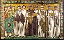
Ravenna Tile

Original from which the Ravenna Tile was copied Sanvitale03.jpg
Original from which the Ravenna Tile was copied

In order to express sympathy following the tornado disaster of June 9, 1961, the Italian city of Ravenna donated a design on a glazed tile to Ravenna, Kentucky. A copy of a Late Antique mosaic from the Basilica of San Vitale, the tile depicts Roman Emperor Justinian I with Maximianus, Bishop of Ravenna. The tile is displayed at the city hall.

Geography

Ravenna is located near the center of Estill County at 37°41′9″N83°57′5″W / 37.68583°N 83.95139°W / 37.68583; -83.95139 (37.685772, −83.951399), [4] in the valley of the Kentucky River. It is bordered to the northwest by the city of Irvine, the county seat. Kentucky Route 52 passes through Ravenna as Main Street and Third Street, leading east and southeast 24 miles (39 km) to Beattyville, and leading west 20 miles (32 km) to Richmond.

According to the United States Census Bureau, Ravenna has a total area of 0.3 square miles (0.8 km2), all of it land. [2]

Climate

The climate in this area is characterized by hot, humid summers and generally mild to cool winters. According to the Köppen Climate Classification system, Ravenna has a humid subtropical climate, abbreviated "Cfa" on climate maps. [5]

Demographics

Historical population
CensusPop.
1930 1,189
1940 1,098−7.7%
1950 979−10.8%
1960 921−5.9%
1970 784−14.9%
1980 7931.1%
1990 8041.4%
2000 693−13.8%
2010 605−12.7%
2020 568−6.1%
U.S. Decennial Census [6]

As of the census [7] of 2000, there were 693 people, 301 households, and 207 families residing in the city. The population density was 1,873.0 inhabitants per square mile (723.2/km2). There were 323 housing units at an average density of 873.0 per square mile (337.1/km2). The racial makeup of the city was 97.55% White, 0.58% African American, 0.72% Native American, and 1.15% from two or more races. Hispanic or Latino of any race were 0.43% of the population.

There were 301 households, out of which 25.9% had children under the age of 18 living with them, 50.8% were married couples living together, 15.3% had a female householder with no husband present, and 31.2% were non-families. 29.6% of all households were made up of individuals, and 16.6% had someone living alone who was 65 years of age or older. The average household size was 2.30 and the average family size was 2.80.

In the city, the population was spread out, with 20.5% under the age of 18, 9.4% from 18 to 24, 28.0% from 25 to 44, 24.2% from 45 to 64, and 17.9% who were 65 years of age or older. The median age was 39 years. For every 100 females, there were 84.3 males. For every 100 females age 18 and over, there were 82.5 males.

The median income for a household in the citywas $30,583, and the median income for a family was $33,438. Males had a median income of $25,833 versus $17,813 for females. The per capita income for the city was $14,089. About 16.0% of families and 17.6% of the population were below the poverty line, including 21.5% of those under age 18 and 12.0% of those age 65 or over.

Noted natives

See also

Related Research Articles

<span class="mw-page-title-main">Powell County, Kentucky</span> County in Kentucky, United States

Powell County is a county located in the U.S. Commonwealth of Kentucky. As of the 2020 census, the population was 13,129. Its county seat is Stanton. The county was formed January 7, 1852, by Kentucky Governor Lazarus W. Powell from parts of Clark, Estill, and Montgomery counties. It is no longer a dry county as of 2018.

<span class="mw-page-title-main">Estill County, Kentucky</span> County in Kentucky, United States

Estill County is a county located in the U.S. state of Kentucky. As of the 2020 census, the population was 14,163. Its county seat is Irvine The county was formed in 1808 and named for Captain James Estill, a Kentucky militia officer who was killed in the Battle of Little Mountain during the American Revolutionary War. Estill County is a moist county meaning that the county seat, the city of Irvine, allows the sale of alcohol after the October 9, 2013 vote, but not the rest of Estill County outside the Irvine city limits. Estill County has two adjacent towns, known as the twin cities, Irvine and Ravenna. Both cities sit along the Kentucky River in the central part of the county. Ravenna is home to a former CSX Transportation facility, now owned by Kentucky Steam Heritage Corporation for the restoration of Chesapeake and Ohio 2716. It conducts the Ravenna Railroad Festival annually in late summer, and the historic Fitchburg & Cottage Furnaces are located here. Irvine hosts the annual Mountain Mushroom Festival over the last weekend of April, which celebrates the abundant Morel Mushrooms found in the region.

<span class="mw-page-title-main">Coolidge, Georgia</span> City in Georgia, United States

Coolidge is a city in Thomas County, Georgia, United States. The population was 525 at the 2010 census.

<span class="mw-page-title-main">Irvington, Kentucky</span> City in Kentucky, United States

Irvington is a home rule-class city in Breckinridge County, Kentucky, in the United States. The population was 1,181 at the 2010 census.

<span class="mw-page-title-main">Winchester, Kentucky</span> City in Kentucky, United States

Winchester is a home rule-class city in and the county seat of Clark County, Kentucky, United States. The population was 18,368 at the 2010 census. It is part of the Lexington-Fayette, KY Metropolitan Statistical Area. Winchester is located roughly halfway between Louisville and Ashland.

<span class="mw-page-title-main">Irvine, Kentucky</span> City in Kentucky, United States

Irvine is a home rule-class city in Estill County, Kentucky, in the United States. It is the seat of its county. Its population was 2,715 at the time of the 2010 census.

<span class="mw-page-title-main">Columbus, Kentucky</span> City in Kentucky, United States

Columbus is a home rule-class city in Hickman County, Kentucky, in the United States. The population was 170 at the 2010 census, a decline from 229 in 2000. The city lies at the western end of the state, less than a mile from the Mississippi River.

<span class="mw-page-title-main">Blaine, Kentucky</span> City in Kentucky, United States

Blaine is a home rule-class city in Lawrence County, Kentucky, United States. The population was 47 at the 2010 census, down from 245 at the 2000 census.

<span class="mw-page-title-main">Hyden, Kentucky</span> City in Kentucky, United States

Hyden is a home rule-class city in and the county seat of Leslie County, Kentucky, United States. The population was 365 at the 2010 census. It is located at the junction of U.S. Route 421 and Kentucky Route 80, along the Middle Fork of the Kentucky River.

<span class="mw-page-title-main">Kuttawa, Kentucky</span> City in Kentucky, United States

Kuttawa is a home rule-class city in Lyon County, Kentucky, in the United States. The population was 649 as of the 2010 census, up from 596 in 2000.

<span class="mw-page-title-main">Calhoun, Kentucky</span> City in Kentucky, United States

Calhoun is a home rule-class city in McLean County, Kentucky, United States. The population was 763 at the 2010 census. It is the county seat of McLean County. It is included in the Owensboro, Kentucky Metropolitan Statistical Area.

<span class="mw-page-title-main">Bardstown, Kentucky</span> City in Kentucky, United States

Bardstown is a home rule-class city in Nelson County, Kentucky, United States. The population was 11,700 in the 2010 census. It is the county seat of Nelson County.

<span class="mw-page-title-main">Hazard, Kentucky</span> City in Kentucky, United States

Hazard is a home rule-class city in, and the county seat of, Perry County, Kentucky, United States. The population was 5,263 at the 2020 Census.

<span class="mw-page-title-main">Morganfield, Kentucky</span> City in Kentucky, United States

Morganfield is a home rule-class city in Union County, Kentucky, in the United States. It is the seat of its county. The population was 3,285 as of the year 2010 U.S. census.

<span class="mw-page-title-main">Springfield, Kentucky</span> City in Kentucky, United States

Springfield is a home rule-class city in and county seat of Washington County, Kentucky, United States. The population was 2,846 at the 2020 census.

<span class="mw-page-title-main">Midway, Kentucky</span> City in Kentucky, United States

Midway is a home rule-class city in Woodford County, Kentucky, in the United States. Its population was 1,641 at the time of the year 2010 U.S. census. It is part of the Lexington-Fayette Metropolitan Statistical Area.

<span class="mw-page-title-main">Paducah, Texas</span> Town in Texas, United States

Paducah is a town in Cottle County, Texas, United States. The population was 1,186 at the 2010 census, down from 1,498 in 2000. It is the county seat of Cottle County. It is just south of the Texas Panhandle and east of the Llano Estacado.

<span class="mw-page-title-main">Williamson, West Virginia</span> City in West Virginia, United States

Williamson is a city in Mingo County, West Virginia, United States, situated along the Tug Fork River. The population was 3,191 at the 2010 census. It is the county seat of Mingo County, and is the county's largest and most populous city. Williamson is home to Southern West Virginia Community and Technical College. The Tug Fork River separates Williamson from South Williamson, Kentucky.

<span class="mw-page-title-main">Dawson Springs, Kentucky</span> City in Kentucky, United States

Dawson Springs is a home rule-class city in Hopkins and Caldwell counties in the U.S. state of Kentucky. As of the 2020 census, the population of the city was 2,452.

<span class="mw-page-title-main">Sparta, Kentucky</span> City in Kentucky, United States

Sparta is a home rule-class city in Gallatin and Owen counties in the U.S. state of Kentucky. The population was 231 at the 2010 census.

References

  1. "2020 U.S. Gazetteer Files". United States Census Bureau. Retrieved March 18, 2022.
  2. 1 2 "Geographic Identifiers: 2010 Demographic Profile Data (G001): Ravenna city, Kentucky". American Factfinder. U.S. Census Bureau. Archived from the original on February 13, 2020. Retrieved February 1, 2016.
  3. (14)." {George C. Wright, A History of Blacks in Kentucky, Volume 2.}
  4. "US Gazetteer files: 2010, 2000, and 1990". United States Census Bureau. 2011-02-12. Retrieved 2011-04-23.
  5. "Ravenna, Kentucky Köppen Climate Classification (Weatherbase)". Weatherbase.
  6. "Census of Population and Housing". Census.gov. Retrieved June 4, 2015.
  7. "U.S. Census website". United States Census Bureau . Retrieved 2008-01-31.