South Carrollton, Kentucky

Last updated
South Carrollton, Kentucky
South-Carrollton-welcome-sign-ky.jpg
Welcome sign along US 431
Muhlenberg County Kentucky Incorporated and Unincorporated areas South Carrollton Highlighted 2171814.svg
Location in Muhlenberg County, Kentucky
Coordinates: 37°20′12″N87°8′30″W / 37.33667°N 87.14167°W / 37.33667; -87.14167
Country United States
State Kentucky
County Muhlenberg
Area
[1]
  Total0.25 sq mi (0.66 km2)
  Land0.25 sq mi (0.65 km2)
  Water0.00 sq mi (0.00 km2)
Elevation
449 ft (137 m)
Population
 (2020) [2]
  Total141
  Density557.31/sq mi (215.39/km2)
Time zone UTC-6 (Central (CST))
  Summer (DST) UTC-5 (CDT)
ZIP code
42374
Area code 270
FIPS code 21-71814
GNIS feature ID0503897

South Carrollton is a home rule-class city in Muhlenberg County, Kentucky, United States. The population was 141 at the 2020 census, [2] down from 184 in 2010. Founded as "Randolph Old Farm" in 1838, an early pioneer changed the name of the city to honor his son, Carroll. [3] The name was prefixed with "South" in order to distinguish it from the city of Carrollton. [4]

Contents

Geography

South Carrollton is located in northern Muhlenberg County at 37°20′12″N87°8′30″W / 37.33667°N 87.14167°W / 37.33667; -87.14167 (37.336799, -87.141719). [5] The city lies along the western bank of the Green River, just north of Central City. U.S. Route 431 traverses South Carrollton, connecting the city with Central City to the south and Island to the north. Kentucky Route 81 intersects US 431 in South Carrollton, connecting the city with Bremen and Sacramento to the northwest.

According to the United States Census Bureau, the city has a total area of 0.25 square miles (0.65 km2), of which 0.001 square miles (0.003 km2), or 0.39%, are water. [1]

Demographics

Historical population
CensusPop.Note
1870 240
1880 493105.4%
1890 5256.5%
1900 452−13.9%
1910 365−19.2%
1920 328−10.1%
1930 3341.8%
1940 296−11.4%
1950 289−2.4%
1960 234−19.0%
1970 218−6.8%
1980 26220.2%
1990 202−22.9%
2000 184−8.9%
2010 1840.0%
2020 141−23.4%
U.S. Decennial Census [6]

As of the census [7] of 2000, there were 184 people, 70 households, and 53 families residing in the city. The population density was 759.2 inhabitants per square mile (293.1/km2). There were 80 housing units at an average density of 330.1 per square mile (127.5/km2). The racial makeup of the city was 97.28% White, 0.54% African American, 0.54% Native American, and 1.63% from two or more races.

There were 70 households, out of which 35.7% had children under the age of 18 living with them, 60.0% were married couples living together, 12.9% had a female householder with no husband present, and 22.9% were non-families. 17.1% of all households were made up of individuals, and 4.3% had someone living alone who was 65 years of age or older. The average household size was 2.63 and the average family size was 2.94.

In the city, the population was spread out, with 22.8% under the age of 18, 9.8% from 18 to 24, 32.1% from 25 to 44, 21.7% from 45 to 64, and 13.6% who were 65 years of age or older. The median age was 39 years. For every 100 females, there were 109.1 males. For every 100 females age 18 and over, there were 118.5 males.

The median income for a household in the city was $27,500, and the median income for a family was $38,750. Males had a median income of $33,125 versus $14,375 for females. The per capita income for the city was $18,183. About 3.7% of families and 14.0% of the population were below the poverty line, including 11.5% of those under the age of eighteen and 9.7% of those 65 or over.

Related Research Articles

<span class="mw-page-title-main">Carrollton, Kentucky</span> City in Kentucky, United States

Carrollton is a home rule-class city in—and the county seat of—Carroll County, Kentucky, United States, at the confluence of the Ohio and Kentucky rivers. The population was 3,938 at the 2010 census.

<span class="mw-page-title-main">Crofton, Kentucky</span> City in Kentucky, United States

Crofton is a home rule-class city in Christian County, Kentucky, in the United States. The population was 749 at the 2010 census.

<span class="mw-page-title-main">Warsaw, Kentucky</span> City in Kentucky, United States

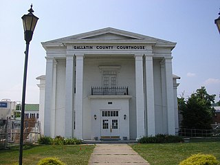
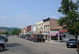
Warsaw is a home rule-class city in and the county seat of Gallatin County, Kentucky, United States, located along the Ohio River. The name was suggested by a riverboat captain, who was reading Thaddeus of Warsaw, by Jane Porter, when the city was being founded.

<span class="mw-page-title-main">Hanson, Kentucky</span> City in Kentucky, United States

Hanson is a home rule-class city in Hopkins County, Kentucky, in the United States. The population was 742 at the 2010 census, up from 625 at the 2000 census.

<span class="mw-page-title-main">Nortonville, Kentucky</span> City in Kentucky, United States

Nortonville is a home rule-class city in Hopkins County, Kentucky, in the United States. The population was 1,204 as of the 2010 census.

<span class="mw-page-title-main">St. Charles, Kentucky</span> City in Kentucky, United States

St. Charles is a home rule-class city in Hopkins County, Kentucky, United States. The population was 277 at the 2010 U.S. Census.

<span class="mw-page-title-main">White Plains, Kentucky</span> City in Kentucky, United States

White Plains is a home rule-class city in Hopkins County, Kentucky, United States. The population was 884 at the 2010 census, up from 800 at the 2000 census.

<span class="mw-page-title-main">Glenview Manor, Kentucky</span> City in Kentucky, United States

Glenview Manor is a home rule-class city in Jefferson County, Kentucky, United States. The population was 191 at the 2010 census.

<span class="mw-page-title-main">Calhoun, Kentucky</span> City in Kentucky, United States

Calhoun is a home rule-class city in McLean County, Kentucky, United States. The population was 725 at the 2020 census. It is the county seat of McLean County. It is included in the Owensboro, Kentucky Metropolitan Statistical Area.

<span class="mw-page-title-main">Island, Kentucky</span> City in Kentucky, United States

Island is a home rule-class city in McLean County, Kentucky, in the United States. The population was 429 at the 2020 census. It is included in the Owensboro metropolitan area.

<span class="mw-page-title-main">Sacramento, Kentucky</span> City in Kentucky, United States

Sacramento is a home rule-class city in McLean County, Kentucky, in the United States. The population was 429 as of the 2020 census. It is included in the Owensboro metropolitan area.

<span class="mw-page-title-main">Bremen, Kentucky</span> City in Kentucky, United States

Bremen is a home rule-class city in Muhlenberg County, Kentucky, in the United States. The population was 172 at the 2020 census.

<span class="mw-page-title-main">Central City, Kentucky</span> City in Kentucky, United States

Central City is a home rule-class city in Muhlenberg County, Kentucky, in the United States. The population was 5,819 at the 2020 census. It is the largest city in the county and the principal community in the Central City Micropolitan Statistical Area, which includes all of Muhlenberg County.

<span class="mw-page-title-main">Drakesboro, Kentucky</span> City in Kentucky, United States

Drakesboro is a home rule-class city in Muhlenberg County, Kentucky, United States. The population was 481 at the 2020 census. Incorporated in 1888, the city was named for early pioneer William Drake.

<span class="mw-page-title-main">Greenville, Kentucky</span> City in Kentucky, United States

Greenville is a home rule-class city in Muhlenberg County, Kentucky, in the United States. It is the seat of its county. The population was 4,492 as of the 2020 census.

<span class="mw-page-title-main">Powderly, Kentucky</span> City in Kentucky, United States

Powderly is a home rule-class city in Muhlenberg County, Kentucky, in the United States. The population was 788 as of the 2020 census.

<span class="mw-page-title-main">Coal Run Village, Kentucky</span> City in Kentucky, United States

Coal Run Village is a home rule-class city in Pike County, Kentucky, in the United States. Bordered to the north, south, and east by Pikeville, the population was 1,706 at the 2010 census. It was the fastest-growing city in Kentucky from 2007 to 2008, with a population increase of 17.3%.

<span class="mw-page-title-main">Wheatcroft, Kentucky</span> City in Kentucky, United States

Wheatcroft is a home rule-class city in Webster County, Kentucky, United States. The population was 173 at the 2000 census.

<span class="mw-page-title-main">West Carrollton, Ohio</span> City in Ohio, United States

West Carrollton is a city in Montgomery County, Ohio, United States. A suburb of Dayton, its population was 13,129 at the 2020 census. It is part of the Dayton Metropolitan Statistical Area. The Great Miami River runs through the town and forms most of its northern border.

<span class="mw-page-title-main">Eubank, Kentucky</span> City in Kentucky, United States

Eubank is a home rule-class city in Pulaski and Lincoln counties in southern Kentucky. The population was 319 at the 2010 census.

References

  1. 1 2 "2022 U.S. Gazetteer Files: Kentucky". United States Census Bureau. Retrieved May 23, 2023.
  2. 1 2 "P1. Race – South Carrollton city, Kentucky: 2020 DEC Redistricting Data (PL 94-171)". U.S. Census Bureau. Retrieved May 23, 2023.
  3. "Dictionary of Places: South Carrollton". Encyclopedia of Kentucky. New York, New York: Somerset Publishers. 1987. ISBN   0-403-09981-1.
  4. Anderson, Bobby (September 19, 2007). "Sandy Called These Names". Leader-News. pp. A12. Retrieved 16 May 2015.
  5. "US Gazetteer files: 2010, 2000, and 1990". United States Census Bureau. 2011-02-12. Retrieved 2011-04-23.
  6. "Census of Population and Housing". Census.gov. Retrieved June 4, 2015.
  7. "U.S. Census website". United States Census Bureau . Retrieved 2008-01-31.