Beechmont, Kentucky | |
|---|---|
 Beechmont  Beechmont | |
| Coordinates: 37°10′28″N87°1′57″W / 37.17444°N 87.03250°W | |
| Country | United States |
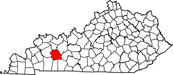
| State | Kentucky |
| County | Muhlenberg |
| Area | |
• Total | 1.82 sq mi (4.73 km2) |
| • Land | 1.82 sq mi (4.71 km2) |
| • Water | 0.01 sq mi (0.02 km2) |
| Elevation | 463 ft (141 m) |
| Population | |
• Total | 776 |
| • Density | 426.61/sq mi (164.72/km2) |
| Time zone | UTC-6 (Central (CST)) |
| • Summer (DST) | UTC-5 (CST) |
| ZIP code | 42323 |
| Area code | 270 |
| FIPS code | 21-05014 |
| GNIS feature ID | 486750 [3] |
Beechmont is a census-designated place and unincorporated community in Muhlenberg County, Kentucky, United States. As of the 2020 census, the population was 776, [2] up from 689 in 2010. The Beechmont post office is located at 3736 Merle Travis Highway. Old National Bank (ONB) is also located at 3740 Merle Travis Highway.