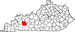
Cleaton, Kentucky

Last updated
Cleaton, Kentucky
USA Kentucky location map.svg
Red pog.svg
Cleaton
Usa edcp location map.svg
Red pog.svg
Cleaton
Coordinates: 37°15′16″N87°5′20″W / 37.25444°N 87.08889°W / 37.25444; -87.08889
Country United States
State Kentucky
County Muhlenberg
Area
[1]
  Total0.62 sq mi (1.61 km2)
  Land0.62 sq mi (1.61 km2)
  Water0.00 sq mi (0.01 km2)
Elevation
440 ft (130 m)
Population
 (2020) [2]
  Total168
  Density270.97/sq mi (104.67/km2)
Time zone UTC-6 (Central (CST))
  Summer (DST) UTC-5 (CST)
ZIP code
42332
FIPS code 21-15490
GNIS feature ID489650 [3]

Cleaton is an unincorporated community and census-designated place in Muhlenberg County, Kentucky, United States. As of the 2020 census, it had a population of 168. [2]

Contents

History

A post office called Cleaton has been in operation since 1901. [4] The name Cleaton was the middle name of the wife of the postmaster. [5]

Geography

Cleaton is in eastern Muhlenberg County northeast of U.S. Route 431, which forms the western edge of the community. The neighborhood of Holt is in the northern part of the CDP, while Bevier is in the southern part. US 431 leads northwest 3.5 miles (5.6 km) to Central City and southeast 4 miles (6 km) to Drakesboro. Greenville, the county seat, is 6 miles (10 km) to the southwest.

According to the U.S. Census Bureau, the Cleaton CDP has an area of 0.62 square miles (1.61 km2), of which 0.003 square miles (0.008 km2), or 0.48%, are water. [1] The community is drained to the southeast by a tributary of Pond Creek, which flows north to the Green River.

Demographics

Historical population
CensusPop.Note
2020 168
U.S. Decennial Census [6]

Related Research Articles

<span class="mw-page-title-main">Muhlenberg County, Kentucky</span> County in Kentucky, United States

Muhlenberg County is a county in the U.S. Commonwealth of Kentucky. As of the 2020 census, the population was 30,928. Its county seat is Greenville and its largest city is Central City.

<span class="mw-page-title-main">Hopkins County, Kentucky</span> County in Kentucky, United States

Hopkins County is a county located in the western part of the U.S. state of Kentucky. As of the 2020 census, the population was 45,423. Its county seat is Madisonville. Hopkins County was created December 9, 1806 from Henderson County. It was named for General Samuel Hopkins, an officer in both the American Revolutionary War and War of 1812, and later a Kentucky legislator and U.S. Congressman.

<span class="mw-page-title-main">Hendron, Kentucky</span> Census-designated place in Kentucky, United States

Hendron is an unincorporated community and census-designated place (CDP) in McCracken County, Kentucky, United States. The population was 4,774 at the 2020 census. It is part of the Paducah, KY-IL Micropolitan Statistical Area.

Reidland is an unincorporated community and census-designated place (CDP) in McCracken County, Kentucky, United States. The population was 4,526 at the 2020 census. It is part of the Paducah, KY-IL Micropolitan Statistical Area.

<span class="mw-page-title-main">Central City, Kentucky</span> City in Kentucky, United States

Central City is a home rule-class city in Muhlenberg County, Kentucky, in the United States. The population was 5,819 at the 2020 census. It is the largest city in the county and the principal community in the Central City Micropolitan Statistical Area, which includes all of Muhlenberg County.

<span class="mw-page-title-main">Drakesboro, Kentucky</span> City in Kentucky, United States

Drakesboro is a home rule-class city in Muhlenberg County, Kentucky, United States. The population was 481 at the 2020 census. Incorporated in 1888, the city was named for early pioneer William Drake.

<span class="mw-page-title-main">Greenville, Kentucky</span> City in Kentucky, United States

Greenville is a home rule-class city in Muhlenberg County, Kentucky, in the United States. It is the seat of its county. The population was 4,492 as of the 2020 census.

<span class="mw-page-title-main">Powderly, Kentucky</span> City in Kentucky, United States

Powderly is a home rule-class city in Muhlenberg County, Kentucky, in the United States. The population was 788 as of the 2020 census.

<span class="mw-page-title-main">South Carrollton, Kentucky</span> City in Kentucky, United States

South Carrollton is a home rule-class city in Muhlenberg County, Kentucky, United States. The population was 141 at the 2020 census, down from 184 in 2010. Founded as "Randolph Old Farm" in 1838, an early pioneer changed the name of the city to honor his son, Carroll. The name was prefixed with "South" in order to distinguish it from the city of Carrollton.

<span class="mw-page-title-main">Greilickville, Michigan</span> Census-designated place & unincorporated community in Michigan, United States

Greilickville is an unincorporated community and census-designated place (CDP) in Leelanau County in the U.S. state of Michigan. At the 2020 census, the population was 1,634, up from 1,530 at the 2010 census. The community is located within Elmwood Charter Township, and is located in the extreme southeast of the Leelanau Peninsula.

Summer Shade is an unincorporated community and census-designated place (CDP) in Metcalfe County, Kentucky, United States. As of the 2020 census, the population was 294.

<span class="mw-page-title-main">Symsonia, Kentucky</span> Census-designated place in Kentucky, United States

Symsonia is an unincorporated community and census-designated place (CDP) in Graves County, Kentucky, United States. The community lies in the far northeastern part of the county, 13 miles (21 km) southeast of Paducah, 11 miles (18 km) northwest of Benton, and 15 miles (24 km) northeast of the county seat Mayfield, in the Jackson Purchase region of the state. As of the 2010 census, the population of Symsonia was 615.

Ezel is an unincorporated community and census-designated place (CDP) in Morgan County, Kentucky, United States. As of the 2020 census, it had a population of 209. It has a small post office, with the ZIP code 41425.

Dwale is an unincorporated community and census-designated place in Floyd County, Kentucky, United States. The 2010 United States Census reported that Dwale's population was 329, of which 312 persons were white and 9 persons were Asian.

Beechmont is a census-designated place and unincorporated community in Muhlenberg County, Kentucky, United States. As of the 2020 census, the population was 776, up from 689 in 2010.

Dunmor is an unincorporated community and census-designated place (CDP) in Muhlenberg and Logan counties, Kentucky, United States. As of the 2020 census it had a population of 322.

Flat Lick is an unincorporated community and census-designated place (CDP) in Knox County, Kentucky, United States. As of the 2010 census, the population was 960.

Holt is an unincorporated community in Muhlenberg County, Kentucky, United States. It is part of the Cleaton census-designated place. Holt is located near U.S. Route 431, 3 miles (4.8 km) south-southeast of Central City.

Doe Valley is an unincorporated community and census-designated place (CDP) in Meade County, Kentucky, United States. Its population was 2,270 as of the 2020 census.

<span class="mw-page-title-main">Beech Grove, McLean County, Kentucky</span> Unincorporated community in Kentucky, United States

Beech Grove is an unincorporated community and census-designated place in McLean County, Kentucky, United States. Its population was 282 as of the 2020 census. Beech Grove has a post office with ZIP code 42322, which opened on April 29, 1878.

References

  1. 1 2 "2022 U.S. Gazetteer Files: Kentucky". United States Census Bureau. Retrieved May 23, 2023.
  2. 1 2 "P1. Race – Cleaton CDP, Kentucky: 2020 DEC Redistricting Data (PL 94-171)". U.S. Census Bureau. Retrieved May 23, 2023.
  3. U.S. Geological Survey Geographic Names Information System: Cleaton, Kentucky
  4. "Muhlenberg County". Jim Forte Postal History. Archived from the original on 8 December 2015. Retrieved 16 April 2015.
  5. Anderson, Bobby (September 19, 2007). "Sandy Called These Names". Leader-News. pp. A12. Retrieved 16 May 2015.
  6. "Census of Population and Housing". Census.gov. Retrieved June 4, 2016.