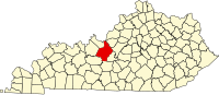
Hardin County is a county located in the central part of the U.S. state of Kentucky. Its county seat is Elizabethtown. The county was formed in 1792. Hardin County is part of the Elizabethtown-Fort Knox, KY Metropolitan Statistical Area, as well as the Louisville/Jefferson County—Elizabethtown-Bardstown, KY-IN Combined Statistical Area. As of the 2020 census, the population was 110,702.

Lebanon Junction is a home rule-class city in Bullitt County, Kentucky, in the United States. The population was 1,746 as of the 2020 census, down from 1,813 as of the 2010 census.
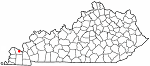
Elizabethtown is a home rule-class city and the county seat of Hardin County, Kentucky, United States. The population was 28,531 at the 2010 census, and was estimated at 31,394 by the U.S. Census Bureau in 2020, making it the 11th-largest city in the state. It is included in the Elizabethtown–Fort Knox, Kentucky Metropolitan Statistical Area, which is included in the Louisville/Jefferson County–Elizabethtown–Madison, Kentucky-Indiana Combined Statistical Area. The Elizabethtown Metropolitan area had a 2019 estimated population of 153,057, making it the 5th-largest metropolitan area in the state.

Nortonville is a home rule-class city in Hopkins County, Kentucky, in the United States. The population was 1,204 as of the 2010 census.
Fern Creek is a historic community in southeastern Jefferson County, Kentucky, United States. The population was 20,009 at the 2008 census. In 2003, The area was annexed to the city of Louisville as part of a merger between the city and Jefferson County's unincorporated communities. Fern Creek was formerly a census-designated place. It is now considered a neighborhood of Louisville. It is located about 12 miles from Downtown Louisville.
Newburg is a former census-designated place in Jefferson County, Kentucky, United States. The population was 20,636 at the 2000 census. On January 6, 2003, the area was annexed to the city of Louisville due to a merger between the city and Jefferson County's unincorporated communities. Newburg is now thought to be a neighborhood within the now merged city of Louisville.
Okolona is a former census-designated place (CDP) in southern Louisville/Jefferson County, Kentucky, United States. It is centered on the intersection of Preston Highway and the Outer Loop. The population was 17,807 at the 2000 census. When the government of Jefferson County merged with the city of Louisville, Kentucky in 2003, residents of Okolona also became citizens of Louisville Metro. As a result, Okolona is said to be a neighborhood within the city limits of Louisville.

Shively is a home rule-class city in Jefferson County, Kentucky, United States, and a suburb of Louisville within the Louisville Metro government. As of the 2010 census, the city's population was 15,264, reflecting an increase of 107 (+0.7%) from 15,157 in 2000.
Hendron is an unincorporated community and census-designated place (CDP) in McCracken County, Kentucky, United States. The population was 4,774 at the 2020 census. It is part of the Paducah, KY-IL Micropolitan Statistical Area.
Reidland is an unincorporated community and census-designated place (CDP) in McCracken County, Kentucky, United States. The population was 4,526 at the 2020 census. It is part of the Paducah, KY-IL Micropolitan Statistical Area.

Central City is a home rule-class city in Muhlenberg County, Kentucky, in the United States. The population was 5,819 at the 2020 census. It is the largest city in the county and the principal community in the Central City Micropolitan Statistical Area, which includes all of Muhlenberg County.
Junction City is a home rule-class city in Boyle County on its border with Lincoln County in the U.S. state of Kentucky. Junction City's population was 2,241 at the 2010 U.S. census. It is part of the Danville Micropolitan Statistical Area.
A census-designated place (CDP) is a concentration of population defined by the United States Census Bureau for statistical purposes only.

Elizabethtown is a hamlet and census-designated place (CDP) in the town of Elizabethtown in Essex County, New York, United States. The population of the CDP was 754 at the 2010 census, out of a total town population of 1,163.

The Louisville metropolitan area is the 43rd largest metropolitan statistical area (MSA) in the United States. It had a population of 1,395,855 in 2020 according to the latest official census, and its principal city is Louisville, Kentucky.

Guthrie is an unincorporated community and census-designated place (CDP) in, and the county seat of, King County in the U.S. state of Texas. It is in the northern part of the state, 93 miles (150 km) east of Lubbock. It serves as the principal headquarters of the Four Sixes Ranch. As of the 2010 census, its population was 160.

Quechee is a census-designated place and one of five unincorporated villages in the town of Hartford, Windsor County, Vermont, United States. As of the 2010 census, the population of the CDP was 656. It is the site of Quechee Gorge on the Ottauquechee River and is also the home to the Quechee Lakes planned community, initiated in the late 1960s, which also brought to the community the small Quechee Lakes Ski Area in the 1970s.
The Elizabethtown–Fort Knox Metropolitan Statistical Area, as defined by the United States Census Bureau, is an area consisting of two counties in Kentucky, anchored by the city of Elizabethtown and the nearby Fort Knox Army post. As of the 2020 census, the MSA had a population of 155,572.

Rineyville is an unincorporated community and census-designated place (CDP) in Hardin County, Kentucky, United States. It is located 7 miles (11 km) northwest of Elizabethtown. The population was 3,039 as of the 2020 Census. The Paducah and Louisville Railway runs north and south through the community.
Maceo is an unincorporated community and census-designated place (CDP) in Daviess County, Kentucky, United States. As of the 2020 census, the population was 404, down from the 2010 census population of 413.