Rhodelia, Kentucky

Last updated
Rhodelia, Kentucky
USA Kentucky location map.svg
Red pog.svg
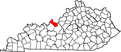
Rhodelia
Location within the state of Kentucky
Usa edcp location map.svg
Red pog.svg
Rhodelia
Rhodelia (the United States)
Coordinates: 38°00′25″N86°25′14″W / 38.00694°N 86.42056°W / 38.00694; -86.42056 Coordinates: 38°00′25″N86°25′14″W / 38.00694°N 86.42056°W / 38.00694; -86.42056
Country United States
State Kentucky
County Meade
Elevation
646 ft (197 m)
Time zone UTC-5 (Eastern (EST))
  Summer (DST) UTC-4 (EST)
ZIP code
40161 [1]
Area code(s) 270 and 364
GNIS feature ID508929 [2]

Rhodelia is a rural unincorporated community in Meade County, Kentucky, United States. It is a small community that lies a few miles west of Brandenburg on KY 144 near its intersection with Rhodes Road and south of KY 144's intersection with KY 259.

History

A post office called Rhodelia was established in 1879. [3] The community was named for Elias Rhodes, a pioneer settler. [4]

Near Rhodelia is St. Theresa Roman Catholic Church, listed on the National Register of Historic Places.

Related Research Articles

<span class="mw-page-title-main">Meade County, Kentucky</span> County in Kentucky, United States

Meade County is a county located in the U.S. state of Kentucky. As of the 2020 census, the population was 30,003. Its county seat is Brandenburg. The county was founded December 17, 1823, and named for Captain James M. Meade, who was killed in action at the Battle of River Raisin during the War of 1812. Meade County is part of the Elizabethtown-Fort Knox, KY Metropolitan Statistical Area, which is included in the Louisville/Jefferson County-Elizabethtown-Madison, KY-IN Combined Statistical Area.

Kidds Store is an unincorporated community in extreme northeastern Casey County, in the U.S. state of Kentucky near the intersection of KY 906 and U.S. Route 127.

<span class="mw-page-title-main">Kentucky Route 70</span> State highway in Kentucky

Kentucky Route 70 (KY 70) is a long east-east state highway that originates at a junction with U.S. Route 60 (US 60) in Smithland in Livingston County, just east of the Ohio River. The route continues through the counties of Crittenden, Caldwell, Hopkins, Muhlenberg, Butler, Edmonson, Barren, Barren, Metcalfe, Green, Taylor, Casey, Pulaski, Lincoln and back into Pulaski again to terminate at a junction with US 150 near Maretburg in Rockcastle.

<span class="mw-page-title-main">Kentucky Route 79</span> State highway in Kentucky

Kentucky Route 79 (KY 79) is a 102-mile-long (164 km) north–south state highway that traverses five counties in west-central Kentucky. It can be seen as an extension of U.S. Route 79 (US 79), as they have the same number; KY 79 begins in the same city that US 79 ends, and both travel on a northeast–southwest diagonal.

<span class="mw-page-title-main">Kentucky Route 259</span> State highway in Kentucky, USA

Kentucky Route 259 is a 95.91-mile-long (154.35 km) state highway that traverses five counties in west-central Kentucky.

<span class="mw-page-title-main">Kentucky Route 2830</span>

Kentucky Route 2830 (KY 2830) is a two-lane, largely rural highway in northeastern Daviess County, Kentucky. The southern terminus is at KY 144 and the northern terminus is at KY 334. The road serves the community of Maceo.

<span class="mw-page-title-main">Flaherty, Kentucky</span> Unincorporated community in Kentucky, United States

Flaherty, an unincorporated community in Meade County, Kentucky, United States, is located 13 miles/21 km south of Brandenburg on KY 144, at its intersection with KY 1600 and KY 1816. While predominantly a rural agricultural community; Flaherty has a modest business district consisting of a Dollar General store, car wash, banks, and a gas station. Notable locations also include: Flaherty Elementary & Primary School, Saint Martin of Tours Catholic Church, Flaherty Ball Park, and Flaherty Fire Department. Clarkson House is also in Flaherty.

Battletown is an unincorporated rural community in Meade County, Kentucky, United States. It is a small unincorporated community that lies a few miles northwest of Brandenburg on KY 228, at its intersection with Pine Ridge Road.

Guston is a rural unincorporated community in Meade County, Kentucky, United States. It is a small unincorporated community that lies a few miles southwest of Brandenburg on KY 428, near its intersection with KY 710.

Payneville is a rural community in Meade County, Kentucky, United States. It is a small community of 1300 residents that lies 7.5 miles west of Brandenburg on KY 144 at its intersection with KY 376.

Roundhill is an unincorporated community in Butler County, Kentucky, United States, situated on Butler County's eastern boundary with Edmonson County.

<span class="mw-page-title-main">Kentucky Route 261</span>

Kentucky Route 261 (KY 261) is a 42.605-mile-long (68.566 km) state highway in Kentucky that runs from Kentucky Route 54 southeast of Fordsville to Kentucky Route 79 and Sandy Hill Road in rural Meade County southwest of Brandenburg via McQuady, Hardinsburg, and Webster.

<span class="mw-page-title-main">Kentucky Route 228</span>

Kentucky Route 228 (KY 228) is a 23.8-mile-long (38.3 km) state highway in the U.S. state of Kentucky. The highway connects mostly rural areas of Meade County with Brandenburg.

<span class="mw-page-title-main">Kentucky Route 313</span>

Kentucky Route 313 (KY 313) is a 33.8-mile-long (54.4 km) state highway in the U.S. state of Kentucky. The highway connects rural areas of Hardin and Meade counties with Radcliff and Vine Grove. The stretch from I-65 to Flaherty Road is also known as the Joe Prather Highway.

<span class="mw-page-title-main">Kentucky Route 376</span>

Kentucky Route 376 (KY 376) is a 5.599-mile-long (9.011 km) state highway in the U.S. state of Kentucky. The highway connects mostly rural areas of Breckinridge and Meade counties with Payneville.

<span class="mw-page-title-main">Kentucky Route 448</span>

Kentucky Route 448 (KY 448) is a 7.555-mile-long (12.159 km) state highway located in Brandenburg, Kentucky. It serves the immediate downtown area.

References

  1. "Rhodelia ZIP Code". zipdatamaps.com. 2022. Retrieved November 11, 2022.
  2. U.S. Geological Survey Geographic Names Information System: Rhodelia, Kentucky
  3. "Meade County". Jim Forte Postal History. Retrieved 25 December 2015.
  4. Rennick, Robert M. Kentucky Place Names. University Press of Kentucky. p. 250. ISBN   0-8131-2631-2.