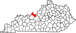
Concordia, Kentucky

Last updated

Concordia is an unincorporated community in Meade County, Kentucky, in the United States. [1]

History

Concordia was incorporated in 1869. [2] A post office called Concordia was established in 1880, and remained in operation until it was discontinued in 1967. [3]

Related Research Articles

<span class="mw-page-title-main">Meade County, Kentucky</span> County in Kentucky, United States

Meade County is a county located in the U.S. state of Kentucky. As of the 2020 census, the population was 30,003. Its county seat is Brandenburg. The county was founded December 17, 1823, and named for Captain James M. Meade, who was killed in action at the Battle of River Raisin during the War of 1812. Meade County is part of the Elizabethtown-Fort Knox, KY Metropolitan Statistical Area, which is included in the Louisville/Jefferson County-Elizabethtown-Madison, KY-IN Combined Statistical Area.

<span class="mw-page-title-main">Breckinridge County, Kentucky</span> County in Kentucky, United States

Breckinridge County is a county located in the Commonwealth of Kentucky. As of the 2020 census, the population was 20,432. Its county seat is Hardinsburg, Kentucky. The county was named for John Breckinridge (1760–1806), a Kentucky Attorney General, state legislator, United States Senator, and United States Attorney General. It was the 38th Kentucky county in order of formation. Breckinridge County is now a wet county, following a local option election on January 29, 2013, but it had been a dry county for the previous 105 years.

<span class="mw-page-title-main">Delhi, Iowa</span> City in Iowa, United States

DelhiDEL-hy is a city in Delaware County, Iowa, United States. The population was 420 at the time of the 2020 census.

<span class="mw-page-title-main">Fredonia, Kentucky</span> City in Kentucky, United States

Fredonia is a home rule-class city in Caldwell County, Kentucky, in the United States. The population was 401 at the 2010 census.

<span class="mw-page-title-main">Brandenburg, Kentucky</span> City in Kentucky, United States

Brandenburg is a home rule-class city on the Ohio River in Meade County, Kentucky, in the United States. The city is 40 miles (64 km) southwest of Louisville. It is the seat of its county. The population was 2,894 at the 2020 census.

<span class="mw-page-title-main">Ekron, Kentucky</span> City in Kentucky, United States

Ekron is a home rule-class city in Meade County, Kentucky, United States. The population was 175 at the 2020 census.

<span class="mw-page-title-main">Marthasville, Missouri</span> City in Missouri, United States

Marthasville is a city in Warren County, Missouri, United States. The population was 1,136 at the 2010 census. The Katy Trail, a 225-mile long bike path, passes through Marthasville.

<span class="mw-page-title-main">Kentuckiana</span> Place in the United States

Kentuckiana, a portmanteau of Kentucky and Indiana, is the area in the Upland South region of the United States containing metropolitan areas with counties in both Kentucky and Indiana. Kentuckiana is primarily the Louisville metropolitan area, including nine counties in Kentucky and five counties in Southern Indiana. This area "is regularly referred to as Kentuckiana".

<span class="mw-page-title-main">Otter Creek Outdoor Recreation Area</span>

Otter Creek Outdoor Recreation Area is a 2,600 acre (11 km²) riverfront park in Meade County, Kentucky. The park is located near Muldraugh and Fort Knox, along State Highway 1638, near U.S. 31W. Although it is located outside Louisville, the park was long operated by the city of Louisville and, after the 2003 merger of the city and Jefferson County, Louisville Metro Government. Both entities attempted to give or sell the park to Meade County and the Commonwealth of Kentucky at various times over the years, most recently in 2004. The park closed in 2009 and reopened in 2011. It is now operated by the Kentucky Department of Fish and Wildlife Resources.

<span class="mw-page-title-main">Louisville metropolitan area</span> Geographic region surrounding Louisville, KY, USA

The Louisville metropolitan area is the 43rd largest metropolitan statistical area (MSA) in the United States. It had a population of 1,395,855 in 2020 according to the latest official census, and its principal city is Louisville, Kentucky.

<span class="mw-page-title-main">Acme, Indiana</span> Unincorporated community in Indiana, United States

Acme is an unincorporated community in Hamilton Township, Jackson County, Indiana.

Surprise is an unincorporated community in Hamilton Township, Jackson County, Indiana.

Kinderhook is an unincorporated community located in Madison and Greene counties, Virginia, United States.

Guston is a rural unincorporated community in Meade County, Kentucky, United States. It is a small unincorporated community that lies a few miles southwest of Brandenburg on KY 428, near its intersection with KY 710.

Buena Vista is an unincorporated community in Taylor Township, Harrison County, Indiana, in the United States.

<span class="mw-page-title-main">Ellinor, Kansas</span> Ghost town in Chase County, Kansas

Ellinor is a ghost town in Chase County, Kansas, United States. It was located southwest of Saffordville, where the BNSF Railway splits.

Eggbornsville is an unincorporated community in Culpeper County, in the U.S. state of Virginia.

<span class="mw-page-title-main">Saint Joseph, Mercer County, Ohio</span>

Saint Joseph is an unincorporated community in Mercer County, in the U.S. state of Ohio.

Rock Haven is an unincorporated community in Meade County, in the U.S. state of Kentucky.

Camp Bartlett is a small, isolated, rural unincorporated community in Upper Ojai, Ventura County, California, United States. Six of the twelve cabins in the community, located east of the city of Ojai, burned down in the Thomas Fire in 2017.

References

  1. U.S. Geological Survey Geographic Names Information System: Concordia, Kentucky
  2. Collins, Lewis (1877). History of Kentucky. p. 599.
  3. "Meade County". Jim Forte Postal History. Retrieved January 25, 2015.

38°03′32″N86°25′41″W / 38.05889°N 86.42806°W / 38.05889; -86.42806