Frankfort is the capital city of the U.S. state of Kentucky and the seat of Franklin County. It is a home rule-class city. The population was 28,602 at the 2020 United States census. Located along the Kentucky River, Frankfort is the principal city of the Frankfort, Kentucky Micropolitan Statistical Area, which includes all of Franklin and Anderson counties. It is the fourth smallest state capital city in the United States by population.

Kenton County is a county located in the northern part of the Commonwealth of Kentucky. As of the 2020 census, the population was 169,064, making it the third most populous county in Kentucky. Its county seats are Covington and Independence. It was, until November 24, 2010, the only county in Kentucky to have two legally recognized county seats. The county was formed in 1840 and is named for Simon Kenton, a frontiersman notable in the early history of the state.

Jefferson County is located in the north central portion of the U.S. state of Kentucky. As of the 2020 census, the population was 782,969. It is the most populous county in the commonwealth.
Campbell County is a county located in the northern part of the U.S. state of Kentucky. As of the 2020 census, the population was 93,076. Its county seats are Alexandria and Newport. The county was formed on December 17, 1794, from sections of Scott, Harrison, and Mason Counties and was named for Colonel John Campbell (1735–1799), a Revolutionary War soldier and Kentucky legislator. Campbell County, with Boone and Kenton Counties, is part of the Northern Kentucky metro community, and the Cincinnati-Middletown, OH-KY-IN Metropolitan Statistical Area.

Jackson is a home rule-class city in and the county seat of Breathitt County, Kentucky, in the United States. The population was 2,231 according to the 2010 U.S. census.

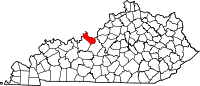
Cynthiana is a home rule-class city in Harrison County, Kentucky, in the United States. The population was 6,402 at the 2010 census. It is the seat of its county.
Annville is an unincorporated community, a census-designated place (CDP), and the largest community in Jackson County, KY. As of the 2020 census, the population was 1,102. The community was established in 1878 and named for local resident Nancy Ann Johnson. The community offers a few services such as a post office, grocery store, gas station, medical clinic, nursing home, restaurants, and other locally owned businesses.
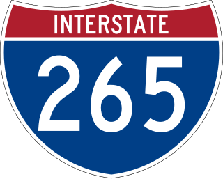
Interstate 265 (I-265) is a 41.8-mile (67.3 km) Interstate Highway partially encircling the Louisville metropolitan area. Starting from I-65 in the southern part of Louisville, it runs through Jefferson County, Kentucky, crosses the Ohio River on the Lewis and Clark Bridge into Indiana, meets I-65 for a second time, and then proceeds westbound to terminate at the I-64 interchange.
Iroquois is a neighborhood on the south side of Louisville, Kentucky, United States. It is split into two parts by Beechmont. From a historical perspective, the northwestern section would be the Bryn Mawr neighborhood and the southeastern section would be the Kenwood neighborhood. The Iroquois neighborhood is roughly bounded by Hazelwood Avenue, Beechmont, Third Street, Kenwood Drive, and Iroquois Park. Located near the Louisville International Airport, residents have frequently complained of noise and challenged airport expansion. The largely residential neighborhood was developed as a suburb after World War II and into the 1950s.

Kentucky Route 70 (KY 70) is a long east-east state highway that originates at a junction with U.S. Route 60 (US 60) in Smithland in Livingston County, just east of the Ohio River. The route continues through the counties of Crittenden, Caldwell, Hopkins, Muhlenberg, Butler, Edmonson, Barren, Barren, Metcalfe, Green, Taylor, Casey, Pulaski, Lincoln and back into Pulaski again to terminate at a junction with US 150 near Maretburg in Rockcastle.
Sweeden is an unincorporated community in north-central Edmonson County, Kentucky, United States. The population of Sweeden's ZCTA was 171 at the 2000 census. It is part of the Bowling Green, Kentucky Metropolitan Statistical Area. The ZIP Code for Sweeden is 42285.

Kentucky Route 259 is a 95.91-mile-long (154.35 km) state highway that traverses five counties in west-central Kentucky.

Kentucky Route 185 is a north–south state highway traversing four counties in west-central Kentucky.
Rhodelia is a rural unincorporated community in Meade County, Kentucky, United States. It is a small community that lies a few miles west of Brandenburg on KY 144 near its intersection with Rhodes Road and south of KY 144's intersection with KY 259.
The Kentucky Mountain Holiness Association (KMHA) is a Christian denomination in eastern Kentucky aligned with Holiness Methodist beliefs. The Association was begun in 1925 by Lela G. McConnell, a deaconess in the Methodist Episcopal Church. The Association maintains a Wesleyan-Holiness doctrine with a strong emphasis on sanctification. The association maintains an elementary school, a high school, a four-year Bible college, two radio stations, a district of churches, and a farm. Philip Speas is the current association president.
Segal is an unincorporated community in west-central Edmonson County in south-central Kentucky, United States. Segal is part of the Bowling Green Metropolitan Statistical Area.

A general election will be held in the U.S. state of Kentucky on November 7, 2023.