South Troy, Minnesota

Last updated

South Troy
South Troy, Minnesota.jpg
South Troy Wesleyan Church
USA Minnesota location map.svg
Red pog.svg
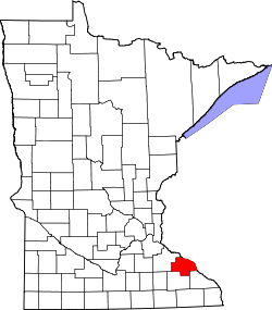
South Troy
Location of the community of South Troy
within Zumbro Township, Wabasha County
Usa edcp location map.svg
Red pog.svg
South Troy
South Troy (the United States)
Coordinates: 44°12′20″N92°26′0″W / 44.20556°N 92.43333°W / 44.20556; -92.43333
Country United States
State Minnesota
County Wabasha County
Township Zumbro Township
Elevation
1,161 ft (354 m)
Time zone UTC-6 (Central (CST))
  Summer (DST) UTC-5 (CDT)
ZIP code
55991
Area code 507
GNIS feature ID654951 [1]

South Troy is an unincorporated community in Zumbro Township, Wabasha County, Minnesota, United States. It is located on U.S. Highway 63 about 13 miles north of Rochester. Nearby places include Hammond, Zumbro Falls, Mazeppa, Potsdam, and Oronoco. Wabasha County Roads 7 and 11 are nearby.

Contents

South Troy had a post office from 1858 to 1903. Nearby Zumbro Falls was originally named Troy in the 1850s. The area south of Zumbro Falls to the Wabasha–Olmsted County line along U.S. 63 was named South Troy. The name of Troy was changed to Zumbro Falls after 1860 because there was already a community named Troy in southeast Minnesota at Winona County.

Notable people

South Troy was known for being a home for Laura Ingalls Wilder, the writer of the Little House on the Prairie series of books, and her family for a short time in the summer of 1876. This is where Charles and Caroline Ingalls fourth child, and their only son, Charles Frederic 'Freddy' Ingalls (November 1, 1875 in Walnut Grove, Minnesota – August 27, 1876 in South Troy), died at the age of 10 months. [2]

Related Research Articles

<span class="mw-page-title-main">Winona County, Minnesota</span> County in Minnesota, United States

Winona County is a county in the U.S. state of Minnesota. As of the 2020 census, its population was 49,671. Its county seat is Winona. Winona County comprises the Winona, MN Micropolitan Statistical Area.

<span class="mw-page-title-main">Wabasha County, Minnesota</span> County in Minnesota, United States

Wabasha County is a county in the U.S. state of Minnesota. As of the 2020 census, the population was 21,387. Its county seat is Wabasha.

<span class="mw-page-title-main">Olmsted County, Minnesota</span> County in Minnesota, United States

Olmsted County is a county in the U.S. state of Minnesota. As of the 2020 census, the population is 162,847. Its county seat and most populous city is Rochester.

<span class="mw-page-title-main">Goodhue County, Minnesota</span> County in Minnesota, United States

Goodhue County is a county in the U.S. state of Minnesota. As of the 2020 census, the population was 47,582. Its county seat is Red Wing. Nearly all of Prairie Island Indian Community is within the county.

<span class="mw-page-title-main">Rochester, Minnesota</span> City in Minnesota, United States

Rochester is a city in the U.S. state of Minnesota and the county seat of Olmsted County. Located on rolling bluffs on the Zumbro River's south fork in Southeast Minnesota, the city is the home and birthplace of the renowned Mayo Clinic.

<span class="mw-page-title-main">Wabasha, Minnesota</span> City in Minnesota, United States

Wabasha is a city and the county seat of Wabasha County, Minnesota. The population was 2,559 at the time of the 2020 census. It is on the Mississippi River, near its confluence with the Zumbro River.

Zumbro Township is a township in Wabasha County, Minnesota, United States. The population was 715 at the 2000 census. The unincorporated community of South Troy is in Zumbro Township.

<span class="mw-page-title-main">Zumbro Falls, Minnesota</span> City in Minnesota, United States

Zumbro Falls is a city along the Zumbro River in Wabasha County, Minnesota, United States. The population was 207 at the 2010 census. U.S. Highway 63 and Minnesota 60 intersect in Zumbro Falls.

<span class="mw-page-title-main">Zumbro River</span> River in the United States of America

The Zumbro River is a tributary of the Mississippi River in the Driftless Area of southeastern Minnesota in the United States. It is 64.6 miles (104.0 km) long from the confluence of its principal tributaries and drains a watershed of 1,428 square miles (3,700 km2). The river's name in English is a change from its French name Rivière des Embarras due to its mouth near Pine Island in the Mississippi River; the pronunciation changed from to. The Dakota name for this river is Wapka Wazi Oju, having reference to the grove of great white pines at Pine Island.

West Albany is an unincorporated community in West Albany Township, Wabasha County, Minnesota, United States.

<span class="mw-page-title-main">Minnesota State Highway 60</span>

Trunk Highway 60 (MN 60) is a 221.532-mile-long (356.521 km) highway in southern Minnesota, which runs from Iowa Highway 60 at the Iowa state line and continues east-northeast to its eastern terminus at the Wisconsin state line, where the route becomes Wisconsin Highway 25 upon crossing the Mississippi River.

<span class="mw-page-title-main">Bridge 5827</span> Bridge in Zumbro Falls, Minnesota

Bridge 5827 is a historic arch bridge in Zumbro Falls, Minnesota, United States, built in 1938 by the Works Progress Administration using a modular corrugated iron product called Multi Plate. It was listed on the National Register of Historic Places as the Bridge No. 5827–Zumbro Falls in 1998 for having state-level significance in the theme of engineering. It was nominated as an example of Minnesota's stone-faced Multi Plate bridges with particularly fine masonry.

<span class="mw-page-title-main">Rochester metropolitan area, Minnesota</span> Metropolitan area in the United States

The United States Census Bureau defines the Rochester, Minnesota Metropolitan Statistical Area (MSA) as an area consisting of five counties in southeast Minnesota, anchored by the city of Rochester. As of 2018, the US Census Bureau estimates that the Rochester metropolitan statistical area has a population of 221,587. The Rochester–Austin combined statistical area has a population of 259,813 as of 2018.

<span class="mw-page-title-main">Bear Valley Grange Hall</span> United States historic place

The Bear Valley Grange Hall is a historic meeting hall in Chester Township, Minnesota, United States. It was built in 1874 for the exclusive use of a local chapter of the National Grange of the Order of Patrons of Husbandry, an early farmers' advocacy group and fraternal organization. The chapter folded in the 1880s and the building has been used since as the Chester Town Hall. It was listed on the National Register of Historic Places in 1989 for having local significance in the theme of social history. It was nominated for being the only surviving Grange hall in Wabasha County—and one of only a few in Minnesota—and a rare example of a purpose-built Grange hall, as most chapters met in existing spaces like schools.

Oak Center is an unincorporated community in Gillford Township, Wabasha County, Minnesota, United States.

Theilman is an unincorporated community in Wabasha County, Minnesota, United States.

Jarrett is an unincorporated community in Wabasha County, Minnesota, United States.

Dumfries is an unincorporated community in Glasgow Township, Wabasha County, Minnesota, United States.

Bear Valley is an unincorporated community in Chester Township, Wabasha County, Minnesota, United States.

References

  1. "South Troy, Minnesota". Geographic Names Information System . United States Geological Survey, United States Department of the Interior.
  2. "Dale Cemetery, Wabasha County, Minnesota"