Hammond, Minnesota

Last updated

Hammond
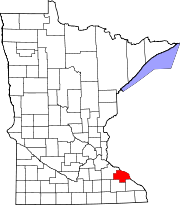
Wabasha County Minnesota Incorporated and Unincorporated areas Hammond Highlighted.svg
Location of Hammond, Minnesota
Coordinates: 44°13′21″N92°22′23″W / 44.22250°N 92.37306°W / 44.22250; -92.37306
Country United States
State Minnesota
County Wabasha
Area
[1]
  Total0.18 sq mi (0.46 km2)
  Land0.16 sq mi (0.42 km2)
  Water0.02 sq mi (0.05 km2)
Elevation
807 ft (246 m)
Population
 (2020)
  Total130
  Density812.50/sq mi (313.16/km2)
Time zone UTC-6 (Central (CST))
  Summer (DST) UTC-5 (CDT)
ZIP code
55991
Area code 507
FIPS code 27-26828 [2]
GNIS feature ID0644609 [3]

Hammond is a city in Wabasha County, Minnesota, United States. The population was 132 at the 2010 census. [4]

Contents

History

Hammond was named for Joseph Hammond, the original owner of the town site. [5]

In September 2010, the city was evacuated due to flooding of the nearby Zumbro River. [6] About two thirds of the homes in the city were severely damaged. [7]

Geography

According to the United States Census Bureau, the city has a total area of 0.12 square miles (0.31 km2); 0.11 square miles (0.28 km2) is land and 0.01 square miles (0.03 km2) is water. [8]

Wabasha County Roads 6 and 11 are main routes in the community.

Demographics

Historical population
CensusPop.Note
1900 238
1910 2411.3%
1920 226−6.2%
1930 184−18.6%
1940 25237.0%
1950 192−23.8%
1960 2056.8%
1970 179−12.7%
1980 178−0.6%
1990 20515.2%
2000 198−3.4%
2010 132−33.3%
2020 130−1.5%
U.S. Decennial Census [9]

2010 census

As of the census [10] of 2010, there were 132 people, 59 households, and 34 families living in the city. The population density was 1,200.0 inhabitants per square mile (463.3/km2). There were 65 housing units at an average density of 590.9 per square mile (228.1/km2). The racial makeup of the city was 97.0% White and 3.0% from other races. Hispanic or Latino of any race were 5.3% of the population.

There were 59 households, of which 18.6% had children under the age of 18 living with them, 37.3% were married couples living together, 10.2% had a female householder with no husband present, 10.2% had a male householder with no wife present, and 42.4% were non-families. 32.2% of all households were made up of individuals, and 6.8% had someone living alone who was 65 years of age or older. The average household size was 2.24 and the average family size was 2.74.

The median age in the city was 45.7 years. 12.9% of residents were under the age of 18; 8.3% were between the ages of 18 and 24; 27.3% were from 25 to 44; 43.2% were from 45 to 64; and 8.3% were 65 years of age or older. The gender makeup of the city was 53.8% male and 46.2% female.

2000 census

As of the census [2] of 2000, there were 198 people, 77 households, and 52 families living in the city. The population density was 1,896.3 inhabitants per square mile (732.2/km2). There were 84 housing units at an average density of 804.5 per square mile (310.6/km2). The racial makeup of the city was 97.98% White, 0.51% African American, 0.51% Native American, 0.51% from other races, and 0.51% from two or more races. Hispanic or Latino of any race were 1.52% of the population.

There were 77 households, out of which 36.4% had children under the age of 18 living with them, 45.5% were married couples living together, 14.3% had a female householder with no husband present, and 31.2% were non-families. 19.5% of all households were made up of individuals, and 3.9% had someone living alone who was 65 years of age or older. The average household size was 2.57 and the average family size was 2.92.

In the city, the population was spread out, with 26.8% under the age of 18, 5.6% from 18 to 24, 38.4% from 25 to 44, 22.2% from 45 to 64, and 7.1% who were 65 years of age or older. The median age was 35 years. For every 100 females, there were 96.0 males. For every 100 females age 18 and over, there were 101.4 males.

The median income for a household in the city was $39,375, and the median income for a family was $38,750. Males had a median income of $30,938 versus $20,625 for females. The per capita income for the city was $18,531. About 12.5% of families and 10.8% of the population were below the poverty line, including 15.8% of those under the age of eighteen and none of those 65 or over.

Related Research Articles

<span class="mw-page-title-main">Wabasha County, Minnesota</span> County in Minnesota, United States

Wabasha County is a county in the U.S. state of Minnesota. As of the 2020 census, the population was 21,387. Its county seat is Wabasha.

<span class="mw-page-title-main">Melba, Idaho</span> Village in Idaho, United States

Melba is a village in Canyon County, Idaho. The population was 513 at the time of the 2010 census, up from 439 in 2000. It is part of the Boise metropolitan area.

<span class="mw-page-title-main">Hammond, Illinois</span> Village in Illinois, United States

Hammond is a village in Piatt County, Illinois, United States. The population was 508 at the 2020 census.

<span class="mw-page-title-main">Kenyon, Minnesota</span> City in Minnesota, United States

Kenyon is a city in southwestern Goodhue County, Minnesota, United States, located along the North Fork of the Zumbro River. It was founded in 1856 and named in honor of Kenyon College. It is known for the Boulevard of roses on main street, which is the namesake of the town festival "Rosefest" held every August. The population was 1,815 at the 2010 census.

<span class="mw-page-title-main">Wanamingo, Minnesota</span> City in Minnesota, United States

Wanamingo is a community in Goodhue County, Minnesota, United States, incorporated as a city. It lies along the North Fork of the Zumbro River. The population was 1,086 at the 2010 census.

<span class="mw-page-title-main">Oronoco, Minnesota</span> City in Minnesota, United States

Oronoco is a city in Olmsted County, Minnesota, United States, along the Middle Fork of the Zumbro River. The population was 1,802 at the 2020 census.

Hyde Park Township is a township in Wabasha County, Minnesota, United States. The population was 275 at the 2000 census.

<span class="mw-page-title-main">Kellogg, Minnesota</span> City in Minnesota, United States

Kellogg is a city in Wabasha County, Minnesota, along the Zumbro River. The population was 456 at the 2010 census.

<span class="mw-page-title-main">Mazeppa, Minnesota</span> City in Minnesota, United States

Mazeppa is a city in Wabasha County, Minnesota, United States, along the North Fork of the Zumbro River. The population was 874 at the 2020 census.

<span class="mw-page-title-main">Mazeppa Township, Wabasha County, Minnesota</span> Township in Minnesota, United States

Mazeppa Township is a township in Wabasha County, Minnesota, United States. The population was 743 at the 2000 census. Mazeppa Township was organized in 1858 and named in honor of Ivan Mazepa, a 17th-century Cossack chief popularized by Lord Byron's poem "Mazeppa".

<span class="mw-page-title-main">Millville, Minnesota</span> City in Minnesota, United States

Millville is a city along the Zumbro River in Wabasha County, Minnesota, United States. The population was 182 at the 2010 census.

<span class="mw-page-title-main">Wabasha, Minnesota</span> City in Minnesota, United States

Wabasha is a city and the county seat of Wabasha County, Minnesota, United States. The population was 2,559 at the time of the 2020 census. It is on the Mississippi River, near its confluence with the Zumbro River.

Zumbro Township is a township in Wabasha County, Minnesota, United States. The population was 715 at the 2000 census. The unincorporated community of South Troy is in Zumbro Township.

<span class="mw-page-title-main">Zumbro Falls, Minnesota</span> City in Minnesota, United States

Zumbro Falls is a city along the Zumbro River in Wabasha County, Minnesota, United States. The population was 155 at the 2020 census. U.S. Highway 63 and Minnesota 60 intersect in Zumbro Falls.

<span class="mw-page-title-main">Mantorville, Minnesota</span> City in Minnesota, United States

Mantorville is a city in Dodge County, Minnesota, United States. The population was 1,197 at the 2010 census. It is the county seat of Dodge County. Founded in 1854, the city is one of the oldest in Minnesota.

<span class="mw-page-title-main">Laporte Township, Sullivan County, Pennsylvania</span> Township in Pennsylvania, United States

Laporte Township is a township in Sullivan County, Pennsylvania, United States. The population was 404 at the 2020 census. Note that Laporte Township surrounds the borough of Laporte.

<span class="mw-page-title-main">Pine Island, Minnesota</span> City in Minnesota, United States

Pine Island is a city in Goodhue and Olmsted counties in the U.S. state of Minnesota. Most of Pine Island is in Goodhue County, but a small part extends into Olmsted County, making that portion part of the Rochester metropolitan area. As of the 2020 census, the population was 3,769.

<span class="mw-page-title-main">Minneiska, Minnesota</span> City in Minnesota, United States

Minneiska is a city in Wabasha and Winona counties in the U.S. state of Minnesota. The population was 97 at the 2020 census.

<span class="mw-page-title-main">Nelson (town), Wisconsin</span>

Nelson is a town in Buffalo County in the U.S. state of Wisconsin. The population was 571 at the 2010 census. The village of Nelson is located within the town. The unincorporated community of Misha Mokwa and railroad junction Trevino are located in the town. The unincorporated community of Urne is located partially in the town.

<span class="mw-page-title-main">Hammond, Wisconsin</span> Village in Wisconsin, United States

Hammond is a village in St. Croix County, Wisconsin, United States. The population was 1,922 at the 2010 census. The village is located within the Town of Hammond. Hammond was home to the Running of the Llamas.

References

  1. "2020 U.S. Gazetteer Files". United States Census Bureau. Retrieved July 24, 2022.
  2. 1 2 "U.S. Census website". United States Census Bureau . Retrieved January 31, 2008.
  3. "US Board on Geographic Names". United States Geological Survey. October 25, 2007. Retrieved January 31, 2008.
  4. "2010 Census Redistricting Data (Public Law 94-171) Summary File". American FactFinder. United States Census Bureau . Retrieved April 27, 2011.[ dead link ]
  5. Upham, Warren (1920). Minnesota Geographic Names: Their Origin and Historic Significance. Minnesota Historical Society. p.  556.
  6. "Hammond, Zumbro Falls remain evacuated". Rochester Post-Bulletin . September 25, 2010. Retrieved September 25, 2010.[ permanent dead link ]
  7. "In flood-damaged cities, no place is home". Rochester Post-Bulletin . September 26, 2010. Archived from the original on September 10, 2012. Retrieved September 27, 2010.
  8. "US Gazetteer files 2010". United States Census Bureau. Archived from the original on January 25, 2012. Retrieved November 13, 2012.
  9. "Census of Population and Housing". Census.gov. Retrieved June 4, 2015.
  10. "U.S. Census website". United States Census Bureau . Retrieved November 13, 2012.

44°13′20″N92°22′25″W / 44.22222°N 92.37361°W / 44.22222; -92.37361